
Apache Trail
Cacti, Roosevelt Dam, and the Tonto National Monument
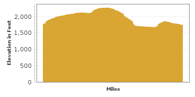
| Mileage | 16 miles (26 km) |
|---|---|
| DurationThe duration is an estimate of a one-way drive and does not include any stops or side-trips. | 22 minutes |
| SeasonsThe seasons listed are the best seasons for this scenic drive. If Winter is not mentioned, the road may be closed during the winter. | Spring, Summer, and Fall |
| Roadways | Arizona Highway 88 |
| Gravel Roads | Yes |
| PassesSome of the adventures on this scenic drive require an admission fee that these passes cover. Please read the drive description for more information. | Tonto National Forest Passes (Arizona) |
| ServicesThe cities or towns listed have either Food or Services such as gas, pharmacies, etc. | Apache Junction, AZ▼, Gold Canyon, AZ▼, San Carlos, AZ▼, Fountain of the Sun, AZ▼, and Sunset Trail Ranch, AZ▼ |
| Rating | 3.9 average from 118 votes |
| My DrivesTrack your favorite scenic drives by selecting those which you want to take and those that you have taken. Using your free account, simply sign in and select My Drives. | |
| Share |

Our free Road Trip Planner will reverse the route and include the places of interests. Click the “Add to Road Trip” above to start planning your next road trip.
Send this link to your phone. Standard text messaging rates apply.
() -Get directions from your start address to the beginning of and including this scenic drive. Choose either an alternate ending or same as start.
Have more destinations? Use our free Road Trip Planner to completely plan your adventure. Click the “Add to Road Trip” above to start planning your next road trip.
Get a Park Pass
Natural areas along this route require an entrance fee used to protect and maintain our most scenic treasures. Save time by purchasing your forest passes before you go.
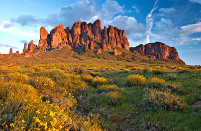
Theodore Roosevelt stated that this was “one of the most spectacular, best-worth-seeing sights in the world.” From stately saguaro cactus forests, the cooler Superstition Mountains, Theodore Roosevelt Dam and two cliff dwellings, this drive explores the diverse treasures of the Tonto National Forest.
The scenic drive starts in the town of Apache Junction. To reach it from Phoenix, head west on Main Street. After the AZ-202 entrance, it will become the Apache Trail until you turn left onto AZ-88. Narrow, windy roads with sharp curves make this an exciting adventure. Drive carefully and park at the many overlooks to take in the incredible views. This road is not recommended if you’re pulling a trailer.
Heading northeast on AZ-88, you leave all traces of the city behind. On the way, consider stopping at the Goldfield Ghost Town (M1). Tour the historic Gold Mine, witness an old west gun fight or take a ride on a narrow gauge railroad. Shortly after, you arrive at Lost Dutchman State Park (H1) which offers many hikes of varying length and difficulty into the Superstition Wilderness and Tonto National Forest. Vast expanses of outstanding beauty, cactus, rocky outcrops, and the chance of sighting a coyote, javelina, jackrabbit, or mule deer await. The park features camping and picnic shelters, as well as guided hikes and programs.
Lost Dutchman State Park is named for Jacob Waltz who is said to have found a gold mine in the 1800s. Legend tells that he hid caches of gold in the Superstition Mountains which so far, has never been found.
Weavers Needle Vista (V1) is a few miles up the road and offers an exceptional view for prospectors trying to find Jacob Waltz’s legendary mine. The striking, 4553 foot Weavers Needle itself is a lava plug that jets up into the sky and is popular for rock climbers.
Entering the Tonto National Forest, the road twists through a forest of saguaro cacti. Seven miles into the drive, you arrive at Canyon Lake. The magnificent beautiful blue hue is a striking contrast to the desert landscape and red rock cliffs. Picture perfect views can be can be seen from Canyon Lake Vista (V2). Canyon Lake (as well as Bartlett and Saguaro Lakes) are very popular with boaters and in peak season can reach maximum boating capacity — we recommend getting there early. The lakes in this region were created when the Salt River was dammed in 1911, and today, offer a variety of recreational opportunities, including swimming, fishing, boating, water-skiing and tubing as well as romantic cruises and tours.
The road twists along Canyon Lake before arriving in the town of Tortilla Flat, a Hollywood set in its past. Remnants of the set remain and there is a Restaurant/Saloon and General Store in one of the original buildings from the 1940s.
Just after Tortilla Flat, the road is unpaved and the continuation of this drive is not depicted on our map above.
If you don’t mind graded dirt roads (and aren’t in an RV), the road continues to Fish Creek Canyon. A one-lane, cliff-hanging road descends more than 1,000 feet — the most scenic and adventurous portion of this drive. Don’t miss the short hike to Fish Creek Vista where you can enjoy the serenity of the rugged canyon. Hikes both up and downstream Fish Creek offer an opportunity to wade, scramble over rocks, taking in the splendor of sheer cliffs and interesting plants.
The road follows many creeks and streams until Apache Lake. Stop at Apache Lake Vista (V3), or enjoy fishing, water skiing or boating on Apache Lake surrounded by Goat Mountain and the Painted Cliffs of the Mazatzal Mountains. Eagles, ospreys, and red-tailed hawks can be seen soaring above. From here, the road quickly descends down to the marina where you will find services such as gas, lodging and food.
As you continue on AZ-88, the paved road resumes as you arrive at the Theodore Roosevelt Dam. Built between 1903 and 1911, at 300 feet tall it is still the largest masonry dam in the world. You can learn more about the dam and how it revolutionized Arizona at the Roosevelt Lake Visitor Center (I2).
Beyond the dam, Theodore Roosevelt Lake is impressive in this desert landscape. Enjoy tranquil beaches, camping and water-based recreation in an area a little less crowded than other lakes.
Head five miles east on AZ-188 and you arrive at the Tonto National Monument (A1) which protects the ruins of two cliff dwellings established by the Salado Indians in the 1300’s. The 20-room Lower Cliff Dwelling is well-preserved and open to visitors. It can be accessed by the half mile Lower Cliff Dwelling Trail. The 40-room Upper Cliff Dwelling can only be visited by a 3-mile round trip ranger-guided tour reserved in advance. Three or four tours are given weekly. Tours are limited to 15 people and often fill quickly; call (928) 467-2241 for reservations. The Visitor Center features a small museum, video presentation and picnic area.
Completing the entire drive brings you to the town of Globe, where you can continue onto Show Low, or to return back to Phoenix, head west on US-60, where you will want to take the Queen Creek Old Tunnel (T1) and stop at the Boyce Thompson Arboretum on the way home.

Share
 | ||||||
| Sun | Mon | Tue | Wed | Thu | Fri | Sat |
|---|---|---|---|---|---|---|
