
White Mountains Scenic Drive
Arizona’s Largest Mountain Range
| Mileage | 55 miles (89 km) |
|---|---|
| DurationThe duration is an estimate of a one-way drive and does not include any stops or side-trips. | 2 hours, 7 minutes |
| SeasonsThe seasons listed are the best seasons for this scenic drive. If Winter is not mentioned, the road may be closed during the winter. | Spring, Summer, and Fall |
| Roadways | Arizona Highways 260 and 273, and Forest Road 249 |
| Gravel Roads | Yes |
| ServicesThe cities or towns listed have either Food or Services such as gas, pharmacies, etc. | Alpine, AZ▼, Greer, AZ▼, McNary, AZ▼, Pinetop-Lakeside, AZ▼, Lakeside, AZ▼, and Pinetop, AZ▼ |
| Rating | 3.4 average from 70 votes |
| My DrivesTrack your favorite scenic drives by selecting those which you want to take and those that you have taken. Using your free account, simply sign in and select My Drives. | |
| Share |

Our free Road Trip Planner will reverse the route and include the places of interests. Click the “Add to Road Trip” above to start planning your next road trip.
Send this link to your phone. Standard text messaging rates apply.
() -Get directions from your start address to the beginning of and including this scenic drive. Choose either an alternate ending or same as start.
Have more destinations? Use our free Road Trip Planner to completely plan your adventure. Click the “Add to Road Trip” above to start planning your next road trip.
Just moments from New Mexico and Show Low, the White Mountain Scenic Drive traverses the forests surrounding Arizona’s largest mountain range, the White Mountains and past Arizona’s second highest peak, Mount Baldy. The tallest peak is the San Francisco Peaks near Flagstaff Passing these gentle giants today become witness hints of its volcanic past.
Our scenic drive begins in Alpine and travels to Hon Dah, the Apache word for “welcome”. Like many of our scenic drives, this one can be done in either direction. You can reach Alpine from US-191 via the Coronado Trail Scenic Byway.
Those wanting to avoid the gravel roads on this scenic drive, you can follow AZ-260 from Springerville to Hon Dah for the entire trip. Though be fore-warned — you will miss a few adventures!
Heading west on the gravel Forest Road 249 (some maps show it as Forest Road 276), you arrive at Williams Valley. Consisting of both open wildflower meadows and lush forest, it is an ideal spot for picnics, easy hikes and mountain biking. Winter creates an ideal playground for cross-country skiing and tobogganing.
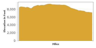
In 5-miles from Three Forks, the road changes to Route 24 and quickly changes again to AZ-273. Keep an eye out for the road to Big Lake (W1). Big Lake is a trout fishing paradise, featuring Rainbow, Brook Cutthroat, Apache and Browns. Boat rentals are available and there is nearby camping. At 9,000 feet of elevation the air is cool and refreshing here, perfect for hiking. The popular half mile Big Lake Nature Trail is a self-guided trail with expansive views that begins near the Visitor Center. The center is only open in spring and summer.
Back on AZ-273 for 2 more miles, the road passes Crescent Lake. Surrounded by forest and rolling meadows, this is an excellent location for fishing or a picnic. Nearby, consider a side-trip when you see AZ-261. On this road, grasslands seem endless and boulders tell of the area’s volcanic past. Ten miles from Crescent Lake lies Mexican Hay Lake (W3), which no birding enthusiast should miss in spring or fall when the bufflehead, mallard, teal, and other ducks visit. Should you continue, you northward, you will pass volcanic cones and the Little Colorado River before arriving at AZ-260.
Back on AZ-273, Mount Baldy, at 11,590 feet of elevation it is the highest point in the White Mountains and the second highest peak in Arizona, the first being the San Francisco Peaks near Flagstaff. Enjoy the pristine beauty of the pine, conifer and spruce forests and lush valleys below. Some hikes will bring you near the summit, however the summit itself is sacred to the Apache of Arizona and is off-limits to hikers.
Note: Many recreation opportunities will be on reservation land. If you plan to do any hiking, fishing or boating, you will need to pick up a permit from the Fort Apache tribe. These can be purchase from sporting goods stores throughout the White Mountains.
Sunrise Park (H3) is home to Sunrise Lake, another perfect fishing or picnic spot or just relax and take in the view. In winter, the area is a skiers and snowboarders wonderland. At the end of AZ-273, the road joins AZ-260, where heading east will bring you to Springerville or heading west will bring you to Hon Dah. This scenic drive continues to Hon Dah.
After entering the White Mountain Apache Indian Reservation, you will pass the Mogollon Rim, an escarpment that defines the southwestern edge of the Colorado Plateau. Formed by erosion and faults, the limestone and sandstone cliffs create impressive canyons below and dramatic views all around. The road then descends into an aspen and pine forest as you reach the picturesque A-1 Lake.
From Hon Dah, you can continue on AZ-73 and join onto I-40 in Holbrook in about an hour and a half, or you could continue the drive via the Globe to Show Low scenic drive in reverse and head towards Phoenix.

Share
 | ||||||
| Sun | Mon | Tue | Wed | Thu | Fri | Sat |
|---|---|---|---|---|---|---|
