

The Levee
A loop around Lake Chicot
| Mileage | 25 miles (41 km) |
|---|---|
| DurationThe duration is an estimate of a one-way drive and does not include any stops or side-trips. | 59 minutes |
| SeasonsThe seasons listed are the best seasons for this scenic drive. If Winter is not mentioned, the road may be closed during the winter. | All Seasons |
| Roadways | Arkansas Highways 144 and 257, and Country Road 49 |
| Gravel Roads | Yes |
| ServicesThe cities or towns listed have either Food or Services such as gas, pharmacies, etc. | Lake Village, AR▼, and Greenville, MS▼ |
| Rating | 3.6 average from 14 votes |
| My DrivesTrack your favorite scenic drives by selecting those which you want to take and those that you have taken. Using your free account, simply sign in and select My Drives. | |
| Share |

Our free Road Trip Planner will reverse the route and include the places of interests. Click the “Add to Road Trip” above to start planning your next road trip.
Send this link to your phone. Standard text messaging rates apply.
() -Get directions from your start address to the beginning of and including this scenic drive. Choose either an alternate ending or same as start.
Have more destinations? Use our free Road Trip Planner to completely plan your adventure. Click the “Add to Road Trip” above to start planning your next road trip.
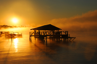
On the banks of the mighty Mississippi River lies Arkansas’s largest natural lake and the largest oxbow lake in the United States, Lake Chicot. Once part of the Mississippi River’s flow, the lake was cut off some 500 years ago when the Mississippi River changed course. This drive loops around a portion of Lake Chicot, passing levees, farmland and wildlife.
Our scenic drive begins at Lake Chicot State Park (H1) which can be reached by heading east on AR-257 from US-65/US-278, following AR-257 and AR-144 east to the park. Nestled in a pecan grove, enjoy outdoor recreation that includes fabulous year-round bird watching of egrets, blue herons, ibis and storks. Popular for boating and fishing for crappie, bass and catfish, or swimming, hiking and camping, the park offers something for everyone. Stop by the visitor center to learn about the area’s history.
From here, head north on AR-257 and then west on AR-144 where in a few miles, the road curves as you arrive in the town of Luna. Just after the bend, turn right onto the gravel Luna Landing Road which leads to Levee Road and one of the world’s longest continuous levee lines totaling more than 650 miles. While the mighty Mississippi is so close, it is barely visible. Along the levee is a bird watchers delight and you may spot a few busy beavers, as well.
Part of the delta region, farmland stretches as far as the eye can see, producing voluminous crops of soybeans, wheat and rice. The road soon parallels the Leland Chute, well known for fishing striped bass and a chance of catching the unusual looking paddlefish.
As the gravel road ends, turn right on Sunnyside Road. You can explore more levees by heading south which leads to the Mississippi River.
Heading west, you will pass Hyner Cemetery. Reflecting the history of the region, Italian immigrants from the late 1800s who worked on the area’s plantations are buried here, many of whom died of malaria.
After crossing the bridge over Lake Chicot, consider a side-trip to Lake Village. Visit the nearby Lakeport Plantation. On the National Register of Historic Places, the Greek Revival home was built in the 1850’s and is now restored as a museum (Note it is only open Monday through Friday and Saturday by appointment only).
History buffs will want to stop at the Ditch Bayou Battlefield on AR-257, the site of the largest Civil War battle in Chicot County. There are other Civil War sites in the area.
Back at the bridge, turn right onto AR-144 and take the next left onto Yellow Bayou Road. In the 1800s, this was the site of the Yellow Bayou Plantation and you will pass its Georgian manor home, which is not open for tours. The Chicot Pumping Station (A1) was built in 1985 to divert the silt-laden run-off caused by forest clearing to make way for cropland. The now clear waters of Lake Chicot are a haven for anglers. The visitor center features the history of the area and of the construction.
Yellow Bayou Road eventually becomes Levee Road and passes the Panther Forest Crevasse (W2). Formed in 1912 when the levees broke, the deep waters of Panther Forest Crevasse are enjoyed by anhingas and ducks.
Following the road east, you will observe the remains of a mound created by the Native Americans 600 years ago. Turn right onto Luna Landing Road and the scenic drive comes to an end as you reach AR-144 where the drive began.

Share
 | ||||||
| Sun | Mon | Tue | Wed | Thu | Fri | Sat |
|---|---|---|---|---|---|---|
