

Ebbetts Pass Scenic Byway
The Sierra Nevada Route
| Mileage | 55 miles (90 km) |
|---|---|
| DurationThe duration is an estimate of a one-way drive and does not include any stops or side-trips. | 1 hour, 6 minutes |
| SeasonsThe seasons listed are the best seasons for this scenic drive. If Winter is not mentioned, the road may be closed during the winter. | Spring, Summer, and Fall |
| Roadways | California Highways 4 and 89 |
| ServicesThe cities or towns listed have either Food or Services such as gas, pharmacies, etc. | Arnold, CA▼, Murphys, CA▼, Markleeville, CA▼, Gardnerville, NV▼, Mountain House, NV▼, Topaz Lake, NV▼, and Woodfords, CA▼ |
| Rating | 3.9 average from 74 votes |
| My DrivesTrack your favorite scenic drives by selecting those which you want to take and those that you have taken. Using your free account, simply sign in and select My Drives. | |
| Share |

Our free Road Trip Planner will reverse the route and include the places of interests. Click the “Add to Road Trip” above to start planning your next road trip.
Send this link to your phone. Standard text messaging rates apply.
() -Get directions from your start address to the beginning of and including this scenic drive. Choose either an alternate ending or same as start.
Have more destinations? Use our free Road Trip Planner to completely plan your adventure. Click the “Add to Road Trip” above to start planning your next road trip.
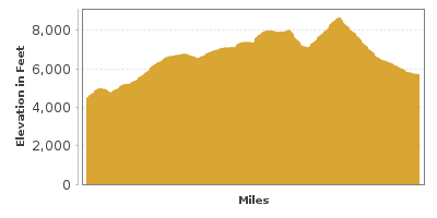
The Ebbetts Pass Scenic Byway travels through the Sierra Nevada’s old-growth Stanislaus National Forest, revealing towering mountain peaks, valleys, unique rock formations, and glacier-carved alpine lakes, as it climbs to an elevation of 8,732-feet along this historic trail.
Take your time driving this steep two-lane curvy road which offers numerous spots to stop and absorb the majestic scenery. This route is not recommended if you’re pulling a trailer. Note: From Lake Alpine heading north to the junction of CA-89 in Markleeville, the road is closed in winter. Check road conditions before heading out.
The scenic drive begins in Arnold and heads north on CA-4 to Markleeville. Before leaving, learn about the impact of the logging and lumber industry on the region at the Sierra Nevada Logging Museum (M1). Open Thursday to Sunday, from April to December.
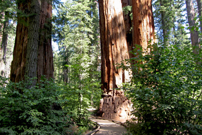
Heading north on CA-4, you will soon arrive in Calaveras Big Tree State Park (H1). The park is home to Sierra redwoods (also known as Giant Sequoias), the largest living entities on the planet. One can only be humbled in their presence. Looming more than 250-feet tall, with a diameter of 30 feet, Sierra redwoods can live over 3,000 years. Take a guided or self-guided hike along the easy 1.5-mile North Grove Trail or walk among giants on the 5-mile South Grove Trail which passes the Agassiz Tree and the Palace Hotel Tree, the parks’ two largest trees. The iconic Pioneer Cabin Tree, also known as the “Tunnel Tree”, sadly fell in a storm on Jan. 8, 2017. Explore other highlights such as the Stanislaus River, Beaver Creek, the Lava Bluff Trail and Bradley Trail. Stop at the Calaveras Big Trees Visitor Center for information, museum exhibits, guided hikes and educational programs. In winter, bundle up for snowshoeing, cross-country skiing and snow-play, then cozy up at the Warming Hut open weekends until late March. Make it an overnight with a cabin rental or camping. All California State Parks have an entrance fee.
A series of three Reservoirs offer excellent fishing, boating, canoeing, kayaking, as well as hiking trails. Spend the day at Union Reservoir, OHV riders will love the Slick Rock Trail at Utica Reservoir, and at Spicer Meadow Reservoir, you’ll find a section where motorized boats are not permitted, offering a peaceful retreat. There are multiple campgrounds in the area. In winter, get your Snow Park Pass and enjoy family-fun cross-country skiing, snowshoeing, dog sledding, and snowmobiling at Spicer Sno-Park.
The byway continues. Take advantage of the many pullouts for photo ops. At Hell’s Kitchen Overlook (V2), kids will love the chance to scramble over rocky outcroppings and observe Balancing Rock.
Year-round recreation awaits at Bear Valley Ski Resort (A2). Activities include hiking, fishing, cycling, golf and disc golf. In winter, 75 runs offer fun for every level of ability. Along with gorgeous views of the High Sierras, you’ll find equipment rentals, lessons, dining options, and seasonal events and festivals. Play longer with a cabin or lodge stay.
At Lake Alpine (W1), rent a kayak or canoe, go fishing, swim at two sandy beaches, or just kick back amid the natural beauty. There are many hiking trails, such as the easy Lakeshore Trail, or the moderately challenging but rewarding hike to Inspiration Point. Make it an overnight with a cabin rental or camping.
Have a picnic lunch in a meadow, then hike or walk the trails. At Woodchuck Basin, the 4-mile roundtrip hike to Wheeler Ridge bestows outstanding views of Lake Alpine, Wheeler Lake, and rugged snow-capped peaks.
A few miles ahead, Cape Horn Vista (V1) offers more sweeping views of the Sierra Nevadas, and the Dardanelle formation. Continuing north, are Mosquito Lakes (W2), two shallow alpine lakes with granite outcroppings. Fuel your adventure with fishing, boating, backpacking, and hiking on the easy Heiser Lake Trail or the moderate Bull Run Lake Trail which forks from it. Have your camera ready to capture beautiful reflections of trees and mountains on the water. There are campsites nearby including Mosquito Lakes Campground, Pacific Valley Campground (A4) and Hermit Valley Campground (A5).
The drive continues to Ebbetts Pass (V3). At 8,732-feet inhale superb vistas including that of the drive’s namesake, Ebbetts Peak. Nearby is parking for the Pacific Crest Trail. Don’t miss the chance to hike a section of this legendary trail, even if you can only manage a short distance. Head north to Kinney Lakes on an easy trail, or south with more significant elevation changes to Noble Lake (8-mile roundtrip). Beauty and solitude will astound.
The byway continues passing Kinney Reservoir which is popular for trout fishing. From here the road descends quickly and if you like hairpin turns, you’re in for a treat. There are unique rock formations on this side of the pass, including Volcanic Neck and Relief Peak. At the bottom of the pass, the road parallels the East Fork of the Carson River, renowned for trout fishing and whitewater rafting.
The drive officially ends in Markleeville, at the junction of CA-89. While here, don’t miss Grover Hot Springs State Park (H2). After a day of hiking, exploring Hot Springs Creek Falls, fishing, or indulging in winter sports, immerse yourself in a 102 to 104 degree soaking pool, or the cold swimming pool. The park features ranger-led activities and camping.
Continue the adventure by visiting the lofty neighbors. Head north to Lake Tahoe or south to Yosemite National Park.

Share
 | ||||||
| Sun | Mon | Tue | Wed | Thu | Fri | Sat |
|---|---|---|---|---|---|---|
