
Billy the Kid Trail
Loop through the mountains
| Mileage | 67 miles (109 km) |
|---|---|
| DurationThe duration is an estimate of a one-way drive and does not include any stops or side-trips. | 1 hour, 29 minutes |
| SeasonsThe seasons listed are the best seasons for this scenic drive. If Winter is not mentioned, the road may be closed during the winter. | All Seasons |
| Roadways | New Mexico Highway 48, and US Highways 380 and 70 |
| ServicesThe cities or towns listed have either Food or Services such as gas, pharmacies, etc. | Ruidoso, NM▼, Capitan, NM▼, Nogal, NM▼, Ruidoso Downs, NM▼, Lincoln, NM▼, and San Patricio, NM▼ |
| Rating | 3.9 average from 92 votes |
| My DrivesTrack your favorite scenic drives by selecting those which you want to take and those that you have taken. Using your free account, simply sign in and select My Drives. | |
| Share |

Our free Road Trip Planner will reverse the route and include the places of interests. Click the “Add to Road Trip” above to start planning your next road trip.
Send this link to your phone. Standard text messaging rates apply.
() -Get directions from your start address to the beginning of and including this scenic drive. Choose either an alternate ending or same as start.
Have more destinations? Use our free Road Trip Planner to completely plan your adventure. Click the “Add to Road Trip” above to start planning your next road trip.
Named after famous outlaw that lived in this area, Billy the Kid Scenic Byway is a short but spectacular mountain loop through the Lincoln National Forest in central New Mexico.
The scenic drive begins in the town of Ruidoso Downs, which can be reached via US-70. To reach US-70, take exit 6 from I-25 and head east. After passing White Sands National Monument, you arrive in Alamogordo where the US-70 heads north and veers back east in Tularosa. After a short drive through the Mescalero Apache Indian Reservation, you arrive in Ruidoso Downs.
In Ruidoso Downs, stop at the Hubbard Museum of the American West (M1) which offers a fascinating glimpse into the wild-west and the history of Native American, Hispanic, and Pioneer life in the region. Conveniently located next door, is the Byway Interpretive Center for information and questions about this route.
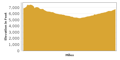
Head west on US-70, passing the Ruidoso Downs Race Track and then head north onto NM-48. Dominating the landscape at 12,000 feet in elevation is the majestic Sierra Blanca. If you’re interested in hiking the pristine beauty of this mountain you will need a permit from the Mescalero Apache Indian Reservation.
Detour to Windy Point (V1) for stunning views up to 100-miles away on clear days from New Mexico’s highest mountain range. Revel in the breathtaking vistas of pine forest, valleys and hills carpeted in many shades of green. To reach it, turn left onto Forest Road 532 in Alto.
A few miles after Alto, you will arrive at the NM-37 intersection. Here, consider a drive down to the extraordinary Valley of Fires State Park (H2). The NM-37 will join onto the US-380 and you will be at the park in about 25 miles. This amazing landscape of twisted and buckled lava 165 feet thick occurred between 1,500 and 5,000 years ago and stretches for 45-miles. Over the lava flow, cactus, trees and dessert brush create a habitat for the many animals that make their home here such as roadrunners, cottontails, lizards, and buzzards. The fully accessible Malpais Nature Trail with interpretive displays starts at the group shelter and leads into the lava flow. The park has a Visitor Center and camping. To come back, just head north on US-380 beyond the NM-37 intersection and head to Capitan.
If you decided not to go to the Valley of Fires, continue north on NM-48 and you will intersect with US-380 in Capitan.
In Capitan, don’t miss a stop at Smokey Bear Historical State Park (H1) which honors the well-known Smokey Bear. Found clinging to a tree after a forest fire in 1950, the cub was rescued and cared for. The bear image had been used since 1944 to promote awareness on fire prevention, but now the world had a real live version. Visit the original Smokey’s grave and Visitor Center which features exhibits about forest health, ecology and fire prevention.
Continuing south on US-380, in 5 miles, consider a side-trip on NM-220 to Fort Stanton (H3). Built in 1855 to protect settlers from Native American invasions, it became the first US hospital specialized in treating tuberculosis in 1899 and later where Japanese and German prisoners were interned during World War II. Though draped in history, the area offers much natural beauty and recreation with more than 60 miles of trails for hiking and horseback riding. Hike the 2-mile Rio Bonito Petroglyph National Recreation Trail or explore Fort Stanton Cave and its fascinating calcite formations. The cave is open by permit only, from April 15 to November 1. It is closed in winter to protect hibernating bats. Contact the BLM Roswell Field office for permits.
Back on US-380 for 7 miles is the Lincoln State Monument (A1), preserving 17 buildings from the 1800s, including the infamous Old Lincoln County Courthouse, where Billy the Kid was jailed until he escaped. There are 4 — 6 museums depending on what season you visit, and a small fee provides access to all.
In 10 miles, the US-380 rejoins the US-70 and the drive continues west back to Ruidoso through the diverse terrain of the Lincoln National Forest. From rugged canyons and gentle sloping hills, forests of pine and fields of cactus, there is a wide variety of recreational and camping opportunities here. For great suggestions, stop at the Smokey Bear Ranger District (I2) in Ruidoso towards the beginning of our drive.
Our drive ends in Ruidoso. If you are heading towards Albuquerque, consider going back via the US-380 within this drive. For the long way back home or to head towards Las Cruces, continue west on US-70 towards Alamogordo, where you can either do a drive up US-82 to Cloudcroft and the Sunspot Scenic Byway (T1); at the end of the Sunspot Scenic Byway, see the sun like never before at the National Solar in Observatory Sunspot (A2). Then work your way back to US-70, stopping at the White Sands National Monument on your way to I-25.
The Tularosa Basin has the most petroglyphs of any region in the United States. If you are heading north, don’t miss the Three Rivers Petroglyph Site (A3) made by the Jornada Mogollon Native Americans and the beautiful surroundings.

Share
 | ||||||
| Sun | Mon | Tue | Wed | Thu | Fri | Sat |
|---|---|---|---|---|---|---|
