
El Malpais National Monument
Along the Lava Fields
| Mileage | 78 miles (125 km) |
|---|---|
| DurationThe duration is an estimate of a one-way drive and does not include any stops or side-trips. | 1 hour, 35 minutes |
| SeasonsThe seasons listed are the best seasons for this scenic drive. If Winter is not mentioned, the road may be closed during the winter. | All Seasons |
| Roadways | New Mexico Highways 117 and 36 |
| ServicesThe cities or towns listed have either Food or Services such as gas, pharmacies, etc. | Grants, NM▼ |
| Rating | 2.8 average from 86 votes |
| My DrivesTrack your favorite scenic drives by selecting those which you want to take and those that you have taken. Using your free account, simply sign in and select My Drives. | |
| Share |

Our free Road Trip Planner will reverse the route and include the places of interests. Click the “Add to Road Trip” above to start planning your next road trip.
Send this link to your phone. Standard text messaging rates apply.
() -Get directions from your start address to the beginning of and including this scenic drive. Choose either an alternate ending or same as start.
Have more destinations? Use our free Road Trip Planner to completely plan your adventure. Click the “Add to Road Trip” above to start planning your next road trip.
About an hour from Albuquerque, this scenic drive heads through the lava fields within El Malpais National Monument. Spanish for “the badlands”, the terrain is a fascinating geologic mix of lava flows, cinder cones, pressure ridges and lava tubes. Created by volcanoes to the southwest a few thousand years ago, El Malpais is an amazing visual splendor with sandstone cliffs and arches, the Zuni Mountains, and distant volcanic craters.
The scenic drive starts a few miles east of Grants. From I-40, take exit 89 and follow the signs for NM-117 south. It’s unlikely that you will miss the exit because the lava flow is very prominent from the highway.
Heading south on NM-117, don’t be discouraged that you are not closer to the lava flow — you’re almost there. Eight miles from I-40, stop at the El Malpais National Monument Visitor Center (I3) to learn more about the lava fields and of the Native Americans cultural history that have lived here for more than 10,000 years. Be sure to pick up a trail guide if you are going hiking.
Just after the visitor center, turn right for the Sandstone Bluffs Overlook (V1). The short road brings you to a cliff for incredible views of the endless lava field and of the Zuni Mountains to the west, and Mount Taylor to the north. This is possibly one of the best views along the entire drive.
To take a closer look at the lava field, stop a few miles later at the Zuni Acoma Trail (H1). An ancient puebloan trade route between the Acoma and Zuni this 7.5-mile one-way trail crosses four of the major flows. You need not do the entire trail to examine the wonders. Wear closed, comfortable shoes as the field can be hot during the summer and use caution when hiking as the lava terrain is sharp and unstable. Never hike alone and always carry water.
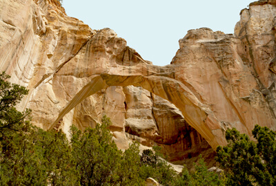
Continuing south along NM-117, you pass several sandstone cliffs and a few arches. La Ventana Natural Arch is New Mexico’s second largest natural arch and the most popular. Visible from the road, you can hike to the base of the arch with a 1/2-mile loop primitive trail. Have your camera ready for the magnificent view of the arch and surrounding cliff formations and dessert plants.
The next stretch of road is known as The Narrows, as the road divides the lava field on the west from the sandstone cliff on the east. The Narrows Overlook (V3) provides another opportunity to marvel at the endless lava field, speckled with desert plants. This is a designated wilderness area that can be explored more deeply with the 6.5-mile round trip Narrows Rim Hike.
To the south, you begin the see the forms of craters. When you reach the NM-41 intersection, this scenic drive heads right to continue on NM-117, however, a short side trip on NM-41 will bring you to the Dittert Site (A1), a two-story masonry home built and occupied by the Anasazi people between 1000 and 1300 AD.
Just past the NM-41 intersection is the turn off for Country Road 42, better known as the Chain of Craters Back Country Byway. The 33-mile gravel road brings you to a chain of 25 cinder cones emerging from weak spots in the earth’s crust. Walk the Continental Divide National Scenic Trail, which winds its way among the craters, through piñon, juniper and pine and is part of the national trail from Mexico to Canada. The road may be impassable when wet.
The monument is home to one of the longest lava tube systems in North America. The tubes and caves are not for a casual hike. If you plan on exploring, be prepared with proper equipment such as protective headgear, light etc. Rangers at the El Malpais Information Center can help with planning.
The road continues through the grass fields with views of the Sawtooth Mountains in the distance, until it climbs and joins onto NM-36 where you will head south (left) on NM-36. In a few miles, you cross the Continental Divide and descend into Quemado. From here, you can return to Albuquerque by heading east on US-60 to I-25 and then north on I-25. You could also consider heading south on I-25 and exploring our other scenic drives, such as the Geronimo Trail or the Billy the Kid Trail

Share
 | ||||||
| Sun | Mon | Tue | Wed | Thu | Fri | Sat |
|---|---|---|---|---|---|---|
