
Catskill Mountains
Scenic Route 30
| Mileage | 95 miles (154 km) |
|---|---|
| DurationThe duration is an estimate of a one-way drive and does not include any stops or side-trips. | 2 hours, 34 minutes |
| SeasonsThe seasons listed are the best seasons for this scenic drive. If Winter is not mentioned, the road may be closed during the winter. | All Seasons |
| Roadways | New York Highway 30 |
| ServicesThe cities or towns listed have either Food or Services such as gas, pharmacies, etc. | Hancock, NY▼, Walton, NY▼, Goulds, NY▼, Pineville, NY▼, Roxbury, NY▼, Hobart, NY▼, Gilboa, NY▼, Stamford, NY▼, more...Lexington, NY▼, Fulton, NY▼, and Mariaville, NY▼ |
| Rating | 3.6 average from 147 votes |
| My DrivesTrack your favorite scenic drives by selecting those which you want to take and those that you have taken. Using your free account, simply sign in and select My Drives. | |
| Share |

Our free Road Trip Planner will reverse the route and include the places of interests. Click the “Add to Road Trip” above to start planning your next road trip.
Send this link to your phone. Standard text messaging rates apply.
() -Get directions from your start address to the beginning of and including this scenic drive. Choose either an alternate ending or same as start.
Have more destinations? Use our free Road Trip Planner to completely plan your adventure. Click the “Add to Road Trip” above to start planning your next road trip.
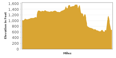
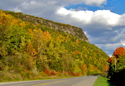
Exploring the southern part of Upstate New York, the Scenic 30 is an idyllic country road that begins at East Branch from the NY-17 interchange in Hancock (near the border of New York and Pennsylvania). Travel through the charming, small towns of the Catskill Mountains to Esperance, NY, and discover a region steeped in early American history and endless natural beauty of rolling mountain vistas.
The hamlets of Shinhopple, Corbett, Colchester and Downsville are nestled in the mountains along the east branch of the Delaware River that flows into the Pepacton Reservoir. The road skirts the shores of the reservoir, winding its way to the village of Margaretville.
Margaretville dates back to the early 1700s and is famous for being the hometown of Dr. Orvan Hess, inventor of the fetal heart monitor. Its natural beauty has been coveted as a location for several feature films.
Here you can continue straight on NY-30 or take advantage of the following activities that lie east of here by turning right on NY-28.
In Arkville, climb aboard the Delaware and Ulster Railroad (A1) for a 2-hour trip back in time. The Arkville station retains its historic charm featuring many original items such as lanterns, china, keys and printed materials. Once known as “The Most Scenic Rail Line in the East”, the train travels to Roxbury Station. The railroad is open from Memorial Day weekend throughout the fall foliage season. Check the website for schedule and prices.
Just past Arkville is Belleayre Mountain (A2) which has been a ski destination since the late 1880s. Today the developed mountain offers 55 trails, parks and glades. In summer, the trails are open for hiking, biking and at Belleayre Beach enjoy swimming, trout fishing and kayaking. Peruse local markets for antiques and produce, then wile the evenings away star-gazing or enjoying the Belleayre Music Festival.
Hunter Mountain (A7) is a popular destination offering year-round recreation. Enjoy superb skiing, snowboarding and snow tubing in winter and in spring, summer and fall partake in the myriad of activities such as hiking, biking, fly-fishing, golfing, zip line, canopy tour and weekend long festivals.
Kaaterskill Falls (W1) is the tallest two-tiered waterfall in New York State with a 260-foot drop-off. Two trails with a combined total of 1.8-miles round trip lead to both the top and bottom of Kaaterskill Falls. Wear good shoes and note the rocks can be slippery. The basin makes a great swimming hole. Take NY-23A in Palenville to access the trailhead.
Much of the Catskills are privately owned, however the Forest Preserve is comprised of 290,000 acres of public land, replete with mountains, lakes, rivers, wetlands, waterfalls and more. Add in 98 peaks over 3,000 feet in elevation and you have superb opportunities for recreation. Depending on the season, partake in boating, fishing, whitewater river tubing, rock climbing, skiing, and snowmobiling. Fly-fisherman will especially love Esopus, Schoharie and Willowemoc creeks. Hundreds of miles of hiking trails offer choices for all skill levels and many are open to biking and horseback riding. Don’t miss a chance climb one of the five fire towers for picture perfect views. Consider making it an overnight or two with tent or RV camping.
If you have taken this side trip, return to NY-30 via NY-23. You will have passed the town of Roxbury.
In Roxbury, visit the Roxbury Depot Museum (M1), part of the Ulster and Delaware Railroad Depot and Mill Complex, which along with the Hamlet of Roxbury, is on the National Register of Historic Places. If you rode the train from Arkville — this is where you will disembark.
Giving new life to the unused section of the railbed from Roxbury to Bloomville is the Catskill Scenic Trail (H1). The 19-mile trail is perfect for walking, biking, horseback riding and in winter, cross-country skiing.
The town of Roxbury is the birthplace of two famous people, Jay Gould, Railroad financier, and naturalist John Burroughs. There are many historic structures in town such as the First and Second Old School Baptist Churches, the Walter Stratton House, and the Isaac Hardenbergh House which can be seen with a self-guided walking tour. Pick up a brochure from the Roxbury Town Hall or Roxbury Library. With so much of the 19th-century architecture intact, the entire hamlet is listed on State and National Registers making this charming, rural town seem light years away from the bustle of New York City. Stroll through the 11-acre Kirkside Park the town hub.
The hamlet of Grand Gorge is located within the boundaries of the township of Roxbury, known as the old Mohican Trail. This is the site of the headwaters of the Delaware River.
NY-30 enters Schoharie County where Schoharie Creek, a tributary of the Mohawk River, contributes to water impounded by the 120-foot Gilboa Dam built in 1926. This reservoir, along with nearby Ashokan Reservoir, are part of the water supply for residents of New York City.
The settlement of Gilboa originated in 1760 and became a town in 1848. It was destroyed due the construction of the Schoharie Reservoir. The Gilboa Museum (M2) is home to the fossilized remains of trees, crinoids, ancient fish and more, including fern-like trees called Wattieza, considered to be the oldest known trees on earth dating from the middle Devonian period, 380 million years ago.
The town of Blenheim and the hamlet of North Blenheim are next on your tour. The Blenheim-Gilboa Visitors Center (I1) of the New York Power Authority is housed in a 19th century dairy barn at the site of the Blenheim-Gilboa Pumped Storage Project in North Blenheim. There is free admission to the Visitors Center where many exhibits and interactive displays tell the story of the Power Project.
Next to the Visitors Center is Lansing Manor (A3). Built in 1819 by John Lansing, the Federal style home has been authentically restored by the Power Authority and is listed in the National Register of Historic Places. Guided tours are offered exploring displays fine 19th century antique furnishings. Visiting the Manor is free, donations are accepted.
Nearby is Mine Kill State Park (H2) known for the Mine Kill Falls, which cascade 80-feet through a narrow gorge. Access to the waterfall trail is one quarter mile south of the main park entrance and it will take you to an overlook viewing platform. You can also reach the falls by hiking the Long Path from the main park to the lower falls. Rounding out the recreation opportunities here are fishing in the lower reservoir for trout, carp and walleye, boating, kayaking and water-skiing. Winter offers snowmobiling, snowshoeing and cross-country ski trails. There is no swimming in the reservoir but enjoy the Olympic size pool, wading pool and a diving pool. As for most New York State Parks, there is a vehicle entrance fee.
Continuing along NY-30 brings you to the town of Middleburgh and the village of Middleburgh settled in 1713. Enjoy the rolling countryside hills, farms and dairies nestled in the valley and the surrounding tree-laden mountains. In fall, the colors are spectacular.
In the town of Fulton is the most prominent geologic feature of the area known as Vroman’s Nose (H3). It derives its name from the Vroman family who were given the land in the early 18th century. This oddly-shaped mountain is a popular hiking spot. The 2-mile loop trail is a moderate climb and at the summit is a large flat surface as if a section of the mountain has been sheared off, referred to as the Dance Floor. Be ready for picture perfect views of the Schoharie Valley.
NY-30 then brings us to the town of Schoharie that also contains a village by the same name. It was settled by Palatine Germans in the early 1700s. During the Revolutionary War the Schoharie area became known as the bread basket for supplying food as this was and still is a prime agricultural area.
Many of the farms and nurseries along this route have farm stands offering homegrown vegetables, fruit, greenhouse crops, baked goods, floral items, herbs and gifts. These stands are open during spring, summer and early fall months.
The Schoharie Colonial Heritage Association (M3) has restored and preserved one of the oldest buildings constructed by Palatine German settlers. The 1743 Palatine House, known as the Old Lutheran Parsonage, was built for the community’s minister, Peter Nicholas Sommers. The house is now a Living Museum and from May to October visitors can take guided tours of the house, grounds, and adjoining cemetery. It is open on weekends from noon to 4pm.
The Old Stone Fort Museum (M4) located in the village of Schoharie was originally a Reformed Dutch Church when first built in 1772, but during the Revolutionary War a log stockade was built around it. A cannonball hole from a skirmish with Mohawk Captain, Joseph Brant and British Loyalists is still evident in a cornice at the rear of the building. In 1857 it was sold to the State of New York but was again used as an armory during the Civil War. Finally in 1888 the Schoharie County Historical Society turned it into a museum and an entire complex of historical structures has grown up around it. Tour the museum complex to see the 1792 William Badgely House and carriage house, the 1830 Jackson Law Office, the Oliver one-room schoolhouse, the Warner House, a Greek Revival structure, and the Schaeffer-Ingold Dutch barn. A research library is also located here and is available to genealogists and historians. The museum complex is listed on the National Register of Historic Places and is open from May through October. Check the website for hours. There is an entrance fee.
Railroad fans will want to visit the Schoharie Valley Railroad Museum (M5). All buildings here were constructed around 1875 and you can tour the brick Passenger Station, the Freight/Locomotive House, the old Mill Building, Freight Shed, and Weigh Station. A restored D and H Caboose contains railroad memorabilia, and an 1891 passenger car, two period boxcars, and a flatbed are at the site. The museum also houses a 1920 scale model of the area, buildings and cars served by the railroad.
Leaving Schoharie, consider a side trip along County Road 1A to the town of Howes Cave where a few highlights await.
Visit the Iroquois Indian Museum (M6) which was built in the form of a traditional longhouse and houses the largest public collection of contemporary Iroquois art in the world. The Iroquois Performing Arts Amphitheater delights with music and dance performances that explore 10,000 years of history of the Native American tribes. Also experience the 45-acre nature park, picnic area and two log houses from the 1850s. There is an entrance fee.
In 1842, Lester Howe explored the Native American legend of the “Blowing Rock” and discovered massive underground caves. Today at Howe Caverns (A4) you can tour the dramatic underground formations. Descend 156-feet into a world of stalactites and stalagmites, an underground riverbed and lake, massive boulders and grottos, and much more. Open year-round, there are a variety of guided tours to choose from with various pricing options.
At Secret Caverns (A5) explore a magnificent 100-foot underground waterfall along with unusual stalactites and stalagmites. The caverns were discovered when in 1928, two cows fell into an 85-foot deep hole. Investigation of the cave led to the end of a passage where a 100-foot underground waterfall was found. Fun tours are available led by trained guides. There is an entrance fee.
Continuing on NY-30, you arrive at the small village of Esperance where our scenic drive officially ends. While here, don’t miss the George Landis Arboretum (A6). Explore the collection of approximately 2,000 specimens of plantings of trees, shrubs, and perennials from around the world via more than eight miles of trails which travel by woodlands, fields, ponds and wetlands. The Arboretum is free (donations appreciated) and open every day from dawn to dusk.

Share
 | ||||||
| Sun | Mon | Tue | Wed | Thu | Fri | Sat |
|---|---|---|---|---|---|---|
