
Rogue-Umpqua Scenic Byway
Drive through the western Cascade Range
| Mileage | 199 miles (321 km) |
|---|---|
| DurationThe duration is an estimate of a one-way drive and does not include any stops or side-trips. | 5 hours |
| SeasonsThe seasons listed are the best seasons for this scenic drive. If Winter is not mentioned, the road may be closed during the winter. | Spring, Summer, and Fall |
| Roadways | Oregon Highways 138, 230, 234, 238, and 62 |
| PassesSome of the adventures on this scenic drive require an admission fee that these passes cover. Please read the drive description for more information. | Pacific Northwest Forest Passes (Washington, Oregon) |
| ServicesThe cities or towns listed have either Food or Services such as gas, pharmacies, etc. | Roseburg, OR▼, Medford, OR▼, Glide, OR▼, Diamond Lake, OR▼, Prospect, OR▼, Shady Cove, OR▼, Eagle Point, OR▼, Jacksonville, OR▼, more...Gold Hill, OR▼, and Grants Pass, OR▼ |
| Rating | 3.9 average from 45 votes |
| My DrivesTrack your favorite scenic drives by selecting those which you want to take and those that you have taken. Using your free account, simply sign in and select My Drives. | |
| Share |

Our free Road Trip Planner will reverse the route and include the places of interests. Click the “Add to Road Trip” above to start planning your next road trip.
Send this link to your phone. Standard text messaging rates apply.
() -Get directions from your start address to the beginning of and including this scenic drive. Choose either an alternate ending or same as start.
Have more destinations? Use our free Road Trip Planner to completely plan your adventure. Click the “Add to Road Trip” above to start planning your next road trip.
Get a Park Pass
Natural areas along this route require an entrance fee used to protect and maintain our most scenic treasures. Save time by purchasing your forest passes before you go.
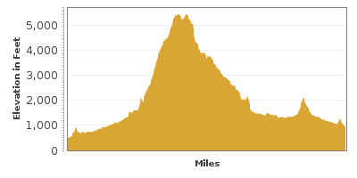
Through the western Cascades and former volcanoes, this scenic drive starts in Roseburg on OR-138. To access this from I-5, take exit 124, keeping right as you follow the signs for OR-138 East.
Heading east on OR-138, surrounded by hills, the drive travels through small towns and farming communities. In 16 miles, you reach the town of Glide, and a breathtaking natural wonder – Colliding Rivers. The deep waters of the North Umpqua River funnel into a water chute and collide with the sparkling Little River causing the water to churn in every direction. This is the only place in the world that this geologic phenomenon occurs. The viewpoint is just across the street from Glide’s Colliding Rivers Information Center (I1).
Continuing east for 6 miles, Swiftwater Park (H2) lies on the banks of the North Umpqua River. Enjoy a picnic or a short hike, or for the avid hiker, the park is the start of a 78 miles trail along the North Umpqua River. Sometimes there are rattlesnakes along the path so take care not to startle them.
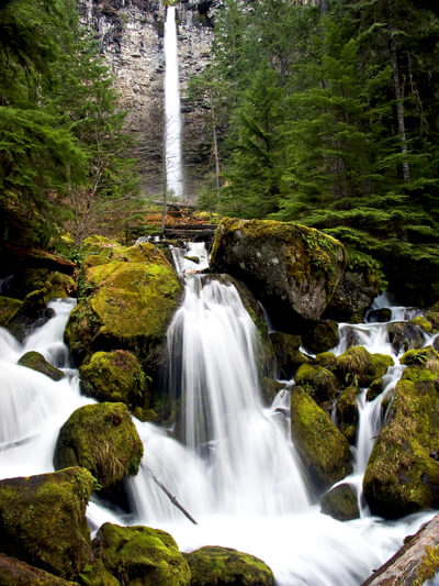
In 6 miles, the Susan Creek Falls (H3) empties into the North Umpqua River with a 50-foot fan-type-waterfall on the left of the road. The trail to the falls is an easy .8 mile walk through lush forest. For the more adventurous you can continue on a more difficult trail to the Indian Mounds, where ancient Indian boys would fast, build stone piles and spend the night in search of a vision from a guardian spirit in order to reach manhood.
Heading east on OR-138, the road parallels the North Umpqua River and traverses through the dense Umpqua National Forest. Two miles from entering the National Forest, the Fall Creek Falls (H4) Trail is a mile long hike through a mostly Douglas fir forest with many volcanic columns culminating with the beauty of Fall Creek Falls.
The drive continues through lush forest heading northeast. In 6 miles, you reach Steamboat. For a scenic side trip, turn left onto Steamboat Creek Road (T1) and head up the windy road for 6 miles where you will be rewarded with Black Gorge and Steamboat Falls.
Continuing east on OR-138, the road continues through forests and hills along the North Umpqua River. In 20 miles, you approach the Toketee Falls Trail (H5). A short 1/3 of a mile walk leads to the overlook of the two-tiered waterfall that plunges into the North Umpqua River Canyon. One of the most famous falls in Oregon, it can be reached by turning left on Toketee-Rigdon Road (Forest Road 34), parking, and hiking to observation area.
Two miles further east is one of Oregon’s tallest waterfalls, Watson Falls (H7). A half-mile hike will bring you to a wooden bridge where you can take in the view of this breathtaking 272-foot waterfall roaring over basalt lava cliffs.
In 11 miles, a side trip to Lemolo Lake (W1) will bring you to sandy beaches at 4,000 feet of elevation. The lake is popular for fishing and boating and equipment is available for rent. To reach it, turn left onto Forest Road 2610.
Shortly after the turn, the road will head south with Mount Thielsen on the right and Mount Bailey on the left, divided by the picturesque Diamond Lake (W2). A 5-mile trail brings you to the Mount Bailey summit and panoramic views of the entire forest.
After Diamond Lake, turn left onto OR-230. If you were to continue on OR-138, you could continue on the Volcanic Legacy Scenic Byway or reach the US-97 in 20 miles.
Heading south onto OR-230, the road is nearly consumed with trees. In 16 miles, consider a side trip to National Creek Falls (H10) by heading east on Forest Road 6530. In 6-miles, a natural formation referred to as Rabbit Ears (T2) is also worthy of a side-trip. The two volcanic crags rise from the earth looking a lot like rabbit ears. To reach Rabbit Ears, turn right onto 6510. In just under two miles, turn right onto FR-6520. In a half mile, turn left onto FR-299 and you reach Rabbit Ears in 5 miles.
In a mile, the OR-230 joins OR-62. This scenic drive officially continues south on OR-62, however, we recommend a side trip to Crater Lake (T3) by heading west on OR-62 for 15 miles until you reach the Crater Lake Highway. Turn left onto Crater Lake Highway leads you to Rim Drive, a 33-mile scenic road around the lake. Crater Lake was formed when Mount Mazama was destroyed over 7,000 years ago and in its place, is a beautiful, crystal clear blue lake.
Heading south on OR-62, the road follows the Rogue River, known for its salmon runs and whitewater rafting. Living up to its name, The Rogue Gorge Viewpoint (V1) offers spectacular views of erosion in action as the churning waters cascade through a narrow channel of basalt lava. Further down the river at the Natural Bridge Viewpoint (V2), the water disappears for 200 yards, swallowed by an underground maze of lava tubes. A trail connects these two areas.
In 20 miles, consider stopping at Stewart State Park. Set on the Rogue River with several Cascade Mountains in the background, it is a perfect place for a picnic or a short hike. The Cole Rivers Hatchery (A1) is open for self-guided tours.
Head south on OR-62 through forests for another 20 miles and turn right onto OR-234. In 7 miles, consider turning left onto Table Rocks Road to Table Rocks (H9), a pair of former volcanoes featuring several short, but not easy hikes.
Continuing on OR-62 for 8 miles through a mix of farmland and hills, you will reach the city of Gold Hill. Just past Gold Hill Regional Park (W3), turn left onto Dardanelles Street, left onto OR-99 (2nd Street), and take your second right onto Access Road, which will become Old Stage Road after you cross I-5. The road continues through scenic towns for 7 miles, where you will need to turn right onto Hillside Drive. In 3 miles, rejoin OR-238 by turning right at California Street.
Heading west on OR-238, the road leaves most of the towns behind as it heads through rolling hills. In 7 miles, you arrive in Ruch where you can take a side trip to Applegate Lake (T4). An angler’s paradise, the calm waters also offer swimming, canoe or kayaking. On the way to the lake, you will pass McKee Covered Bridge (B1), operational between 1917 and 1956. This restored, historic bridge can now be crossed by foot. At Applegate Lake, don’t miss the Swayne Viewpoint (V3) for an incredible view of Applegate Dam and Intake Tower and surrounding peaks including the Red Buttes, Kangaroo Mountain, and Cook and Green Butte to the south, Stein Butte and Elliott Creek Ridge to the southeast, Little Grayback Mountain to the east, and Woodrat Mountain to the north.
Our drive continues on OR-238 until it ends in Grants Pass. From here, consider a road trip to the Redwood Highway by heading south on US-199, where you can join onto US-101 and head up the Oregon Coast or head to the Volcanic Legacy Scenic Byway for more volcanic history.

Share
 | ||||||
| Sun | Mon | Tue | Wed | Thu | Fri | Sat |
|---|---|---|---|---|---|---|
