

The Oregon Coast
An ocean scenic drive
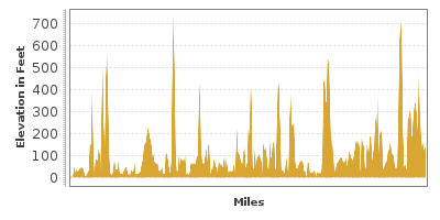
| Mileage | 338 miles (544 km) |
|---|---|
| DurationThe duration is an estimate of a one-way drive and does not include any stops or side-trips. | 6 hours |
| SeasonsThe seasons listed are the best seasons for this scenic drive. If Winter is not mentioned, the road may be closed during the winter. | All Seasons |
| Roadways | US Highway 101 |
| PassesSome of the adventures on this scenic drive require an admission fee that these passes cover. Please read the drive description for more information. | Pacific Northwest Forest Passes (Washington, Oregon) |
| ServicesThe cities or towns listed have either Food or Services such as gas, pharmacies, etc. | Astoria, OR▼, Warrenton, OR▼, Seaside, OR▼, Manzanita, OR▼, Tillamook, OR▼, Lincoln City, OR▼, Depoe Bay, OR▼, Yachats, OR▼, more...Florence, OR▼, Reedsport, OR▼, Lakeside, OR▼, Bandon, OR▼, Port Orford, OR▼, Brookings, OR▼, Newport, OR▼, Coquille, OR▼, Gold Beach, OR▼, Gearhart, OR▼, Cannon Beach, OR▼, Pacific City, OR▼, and Northbend, OR▼ |
| Rating | 3.5 average from 371 votes |
| My DrivesTrack your favorite scenic drives by selecting those which you want to take and those that you have taken. Using your free account, simply sign in and select My Drives. | |
| Share |

Our free Road Trip Planner will reverse the route and include the places of interests. Click the “Add to Road Trip” above to start planning your next road trip.
Send this link to your phone. Standard text messaging rates apply.
() -Get directions from your start address to the beginning of and including this scenic drive. Choose either an alternate ending or same as start.
Have more destinations? Use our free Road Trip Planner to completely plan your adventure. Click the “Add to Road Trip” above to start planning your next road trip.
Get a Park Pass
Natural areas along this route require an entrance fee used to protect and maintain our most scenic treasures. Save time by purchasing your forest passes before you go.
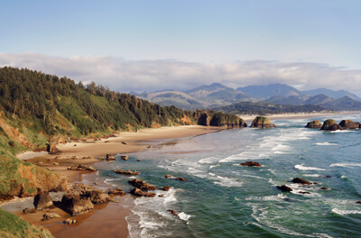
This scenic drive starts in Astoria and travels along Oregon’s Pacific Ocean Coastline all the way down the Brookings. Many portions of US-101 hug the Pacific Coast and offer spectacular views of the Pacific Ocean and the surrounding forests. Each town along the route boasts it's own charms and range of services, including lodging, restaurants, and shopping. There are a myriad of beaches and day use areas - more than mentioned here, so be sure to stop as the whim takes you. Note that some beaches are free and some require a day use fee which is covered by a Pacific Northwest Annual Pass or an America the Beautiful Annual Pass.
The scenic drive encompasses three of Oregon’s Scenic Byways: the Northern Oregon Coast which travels from Astoria to Pacific City, the Central Oregon Coast from Cascade Head to Bandon, and the Southern Oregon Coast which is the stretch from Bandon to Brookings.
To reach Astoria from I-5, take exit 36 for WA-432. In a mile and half, turn right onto WA-433 and then turn right onto US-30 and continue until you reach Astoria, where the US-30 becomes the US-101. Alternatively, take exit 40 for WA-4 and do the Columbia River and Long Beach drive the Astoria-Megler Bridge, where you will head south and continue from there.
On the US-101, head south from Astoria over the Young’s Bay Bridge (B3). Consider taking a side trip to Fort Clatsop National Memorial (T1) where Lewis and Clark camped during the winter of 1805. Explore a replica of the fort and during summer, experience what life was like in the 1800s through costumed interpreters and ranger-led programs. Or walk in the footsteps of Lewis and Clark on all or part of the 6.5-mile round trip Fort to Sea Trail which begins at the Visitor Center and ends at Sunset Beach. To get there, turn left on SE Marlin Drive, which merges onto US-101 Bus. In about two miles, turn right on Fort Clatsop Road for a half of a mile.
For a diverse mix of nature and historical adventure, visit Fort Stevens State Park (W1). During World War II, the park was used as part of a defense system to protect the Columbia River from attacks. Today, you can enjoy its beaches on the Pacific Ocean and the Columbia River and hikes through its 3,700 acres rich with spruce and hemlock forests, wetlands, dunes, and shore pine. To reach it, head west on OR-104S for about a mile. Turn left on Fort Stevens Street, then a right on SE 18th Street. SE 18th Street will become NW Ridge Road, and in a mile and a half, you can turn left on Jetty Road, which will bring you to the park.
Heading south on US-101, Ecola State Park (W2) is also Lewis and Clark territory and today you can explore on interpretive trails or an eight mile segment of the Oregon Coast Trail. The park features nine miles of stunning ocean coastline perfect for whale watching and tide-pooling. Get there by turning west on Radar Road. In two miles, turn right onto Cannon Beach Trail until the end.
Cannon Beach (W3) is a popular destination, known for its spectacular ocean views and endless, white-sand beach. Dominating the scene sits a 235-foot tall monolith known as Haystack Rock and low tide offers the chance to get up close. The town of Cannon Beach is two miles from Radar Road, and any of the roads into the town will bring you straight to the beach.
In 9 miles, Oswald West State Park (W4) features superb hiking through a dense forest of Douglas fir, Sitka spruce, western hemlock, and red cedar, and of course, beach access and dazzling ocean views.
The small town of Garibaldi is a haven for commercial and sport fishing. Learn more about the maritime heritage of the Pacific Northwest at the Garibaldi Maritime Museum (M4) through models of two historic ships, the Columbia Rediviva and the Lady Washington, interactive exhibits, photographs, artifacts and more. There is a small entrance fee. Garibaldi is also home to Pig and Sows Inlet, named for the very photogenic rocky outcrop.
Tillamook lies 30 miles ahead, and from here consider taking a side trip on the Three Capes Scenic Loop (T2), which connects Cape Meares State Park (W5), Cape Lookout State Park (W6), and Cape Kiwanda State Park (W7). For this loop, turn right onto 3rd Street/OR-131 and use the signs as your guide. In about a mile and a half, the road will curve. Take Bayocean Road is on the right and follow it to the end, where you will turn left on Cape Meares Loop/Bayshore Drive. In one mile, you arrive in Cape Meares State Park (W5), home to the Cape Meares Lighthouse built in the 1890s. Don't miss the unusual multi-limbed Octopus Tree - a Sitka spruce. Trails offer impressive views of the coastal rocks and of a sea lion rookery.
Continuing down Cape Meares Loop, the road joins OR-131. When you reach Oceanside and the road hugs the coastline again before arriving in Netarts. Turn right onto Netarts Bay Drive. In five miles, you will arrive at the Cape Lookout State Park (W6). Encompassing a landscape formed by lava flows, Cape Lookout State Park juts out into the Pacific Ocean which affords phenomenal views of the rugged coast and the Pacific Ocean. Revel in 2,000 acres of rainforest and glorious sandy beaches. The park also offers camping, yurts and cabins. If you plan to travel the coast in peak summer months you should reserve camping and/or hotels in advance to avoid disappointment.
Continuing on the Three Capes Scenic Loop, head down Cape Lookout Road for 5 miles until it intersects with Sandlake Road. Turn right onto Sandlake Road and continue on Sandlake Road for 7 miles to Cape Kiwanda State Park (W7). Kiwanda State Park is known for its picturesque yellow-red sandstone cliffs, dunes, beach access, and hiking trails.
To head back to US-101, head south on Cape Kiwanda Drive. Turn right onto Pacific Ave and head over the bridge, where you will want to take the second right onto Brooten Road. In just under three miles, you will rejoin the US-101 near Neskowin..
Continuing south on US-101, you reach Lincoln City, a vibrant town offering lodging, restaurants and great antiquing. Shoppers will also love the outlet mall. Ten miles from Lincoln City is an exit for Boiler Bay State Park (W8), a stop that you should definitely not miss as along with incredible ocean views, it is one of the best locations to spot migrating and resident gray whales. A short, rough trail takes you to some of Oregon’s richest tidepools.
About 3 miles from here, consider turning right onto Otter Crest Loop (T3) for a more coastal drive. In two miles, the Cape Foulweather Visitor Center (I3) will be on your right and features another spectacular view of the ocean. About a mile up the road, turn right onto 1st Avenue to reach Devils Punchbowl State Park (W9) , so named as at high tide, seawater swirls within a cavern appearing like a punchbowl. This park features 180-degree ocean views, whale sightings, fascinating rock formations, and is very popular with surfers and surf watchers. After a stop here, continue south on Otter Crest Loop to rejoin US-101.
Continuing south on US-101, the highway offers spectacular views of the ocean. Stop at one of the many beaches, including the Beverly Beach State Park (W29) or the Agate Beach State Park (W30).
Stop at the Yaquina Head Outstanding Natural Area (H10). Truly deserving of it's name, outstanding views abound, including an overlook to resident sea lions as they bask on rocky outcrops, fabulous tide pools and an exceptional Visitor Center which describes the natural history of the area via interpretive panels. In summer, costumed interpreters retell the history of the lighthouse and visitors are welcome to climb to the top. There is a fee to enter covered by the America the Beautiful Annual Pass.
In 7 miles, you will arrive in Newport, which features the Oregon Coast Aquarium (A1), and the Hatfield Marine Science Center (A2). South Beach State Park delights with expansive sandy beaches and dunes. It is also a popular spot for camping.
For the next 24 miles, the US-101 hugs the coast with very few exceptions and the view is just breathtaking. A few miles after Yachats, Cape Perpetua (H5) is one of the most scenic stops on this trip. With a bluff 800 feet above the ocean, it offers a high vantage viewpoint to the powerful ocean, the occasional passing whale, and rich tidepools below. Cape Perpetua has several trails through its misty rainforests filled with old-growth Sitka spruce trees. Don’t miss the 2-mile roundtrip trail leading to a 500-year-old Sitka spruce.
13 miles from Yachats, the Heceta Head Lighthouse (V1) sits on a bluff overlooking the ocean. Immediately after this is Devils Elbow State Park (W14) which also offers a trail to the lighthouse, picnic tables sheltered from the wind, and spectacular views of the coast and Pacific Ocean.
Continuing south on US-101, the Sea Lion Caves (H2) is one of the few places in the United States where sea lions reside year-round. A series of stairs and an elevator brings you to the caves where the golden brown Steller sea lion and the darker California sea lion live. There is an admission fee.
As you leave the caves, the US-101 leaves the Pacific coast. In 10 miles, you will enter Florence. If you visit towards the end of May, it will be clear why this colorful city is known as the City of Rhododendrons.
As you leave Florence, you will enter the Oregon Dunes National Recreation Area (W15). Towering 500-feet above sea level, the sand dunes provide many recreational opportunities such as hiking, horseback riding, beach access, and three separate areas for off-road vehicle driving. The Dunes continue for 41 miles to the south where the peninsula juts into Coos Bay.
21 miles from Florence is Reedsport and the Reedsport Information Center (I1) is a great source for area maps and information. 5 miles from Reedsport is the Umpqua Lighthouse State Park (W16), the oldest lighthouse in Oregon. Turn west onto the Lighthouse Road to the end to reach it. There is a whale watching station nearby where you can get a great view of the surrounding shores, dunes, and ocean.
Winchester Bay is a small fishing village where you can pick up fresh seafood or taste locally harvested oysters before getting back on the road. The town features RV camping and OHV access.
Continuing on US-101, explore Oregon’s highest sand dunes on the John Dellenback Dunes Trail. Hike through forest before arriving at the the towering dunes where the 6-mile round trip trip ultimately leads to the beach. This is a strenuous walk due to the difficulty of trudging through the sand but even if you don't go all the way, the endless ridges of undulating sand is a spectacular sight.
In North Bend, consider a detour on the Three Parks Scenic Loop (T4) to Sunset Bay, Shores Acres, and Cape Arago State Parks. For this side trip, turn left onto Cape Arago Highway from the US-101. Stop at Sunset Bay State Park to explore Douglas firs, sea stacks, and the Pacific Ocean. The waters here are said to be the safest waters along the Oregon coast. This is the only one of these three state parks to offer camping.
Within a mile, Shores Acres State Park will be on the right. This was the estate of timber baron Louis J. Simpson and has several acres of award-winning gardens, including a Japanese garden. Between Thanksgiving and New Year’s Eve, the park is illuminated with more than 250,000 lights.
Cape Arago State Park features breathtaking ocean views and of migrating whales. Trails lead down to the beach where you can delicately explore tidepools.
To return to US-101, retrace the route for six miles and turn right onto Walker Ave and right again onto 7 Devils Road. Continue on 7 Devils Road for about six miles and take a left onto West Beaver Hill Road. In 6 miles, you will be back on the US-101.
9 miles from where West Beaver Hill Road meets US-101 or 26 miles from North Bend on the US-101, you will reach Bandon, the Cranberry Capital of Oregon. A few of the cranberry bogs are visible from the highway. From here to Cape Blanco, the drive travels along forests, rural areas, sea stacks, and magnificent ocean views.
In 22 miles from Bandon, turn right onto Cape Blanco Road for Cape Blanco State Park (W21), home of Oregon’s western-most lighthouse and the historic Hughes home. In addition, it offers great hikes and black sand beach access.
In 4-miles, you will be in Port Orford, one of Oregon’s oldest coastal settlements. Port Orford Heads State Park (W22) offers beach access and hiking trails.
After Port Orford, the road once again hugs the coastline for the next five miles. On the way, Humbug Mountain State Park (W23) is dominated by the 1,756-foot Humbug Mountain, one of the largest mountains in Oregon to rise directly from the ocean. This area has some of the warmest weather on the Oregon coast as the surrounding mountains offer protection from the cool ocean winds.
Continuing south on US-101, ocean scenic drive has endless stunning views and many state parks. 21 miles ahead, you will cross the historic Isaac Patterson Bridge (B5) and a loop drive through the Siskiyou National Forest can be done on the Rogue-Coquille Scenic Byway.
As you continue on US-101, Cape Sebastian State Park (W25) is in 6-miles and has beach access and majestic Sitka spruce forests. But even if you aren’t interested in those, a stop at its two parking lots, both 200 feet above sea level affords spectacular views.
In 13 miles from Cape Sebastian is the Samuel H. Boardman State Park (W27), featuring 12 miles of coastal and forested state park, where you can admire 300-year old Sitka spruce trees and walk through 27-miles of trails weaving through dense, old-growth forests. Samuel H. Boardman was Oregon Park’s first superintendent and thanks to people like him, we can enjoy this vast and pristine nature landscape.
In eight miles, you will reach Harris Beach State Park (W28). In addition to beach access, Harris Beach State Park is a National Wildlife Sanctuary and breeding site for birds such as the rare tufted puffin. One mile from here, the city of Brookings, which marks the end of this drive. Azalea State Park (H4) offers more than 25 acres of dazzling azaleas.
From here, you can continue down the US-101 into California for the Redwood Highway.

Share
 | ||||||
| Sun | Mon | Tue | Wed | Thu | Fri | Sat |
|---|---|---|---|---|---|---|
