
Newfound Gap Road
Great Smoky Mountains National Park
| Mileage | 31 miles (50 km) |
|---|---|
| DurationThe duration is an estimate of a one-way drive and does not include any stops or side-trips. | 51 minutes |
| SeasonsThe seasons listed are the best seasons for this scenic drive. If Winter is not mentioned, the road may be closed during the winter. | Spring, Summer, and Fall |
| Roadways | Newfound Gap Road |
| ServicesThe cities or towns listed have either Food or Services such as gas, pharmacies, etc. | Gatlinburg, TN▼, Pigeon Forge, TN▼, Bryson Place, NC▼, Cherokee, NC▼, Whittier, NC▼, Bryson City, NC▼, Dillsboro, NC▼, and Sylva, NC▼ |
| Rating | 4.0 average from 69 votes |
| My DrivesTrack your favorite scenic drives by selecting those which you want to take and those that you have taken. Using your free account, simply sign in and select My Drives. | |
| Share |

Our free Road Trip Planner will reverse the route and include the places of interests. Click the “Add to Road Trip” above to start planning your next road trip.
Send this link to your phone. Standard text messaging rates apply.
() -Get directions from your start address to the beginning of and including this scenic drive. Choose either an alternate ending or same as start.
Have more destinations? Use our free Road Trip Planner to completely plan your adventure. Click the “Add to Road Trip” above to start planning your next road trip.
Explore the Great Smoky Mountains National Park, the most visited national park in the United States, via a spectacular roadwork built in the 1930s that includes tunnels, stone bridges and ample twisty roads.

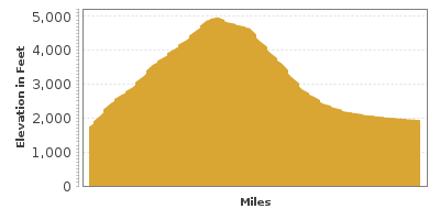
The scenic drive begins in the town of Gatlinburg, TN and ends in Cherokee, NC. Make your first stop the Sugarlands Visitor Center (I1) where you can get information to personalize your experience and learn more through the interpretive exhibits and short film or by participating in a ranger led program. Consider exploring the Cades Cove Loop which is 25-miles south of here. The scenic drive takes you back in time to the 1800s when a thriving community lived in these hills.
Before beginning the drive, consider a side-trip on the Roaring Fork Motor Nature Trail (T1) which is accessible from Gatlinburg’s Airport Road which then becomes Cherokee Orchard Road. As the sign says, this very narrow crooked one way road travels the serene forest offering spectacular views and pullouts. A 1.2 mile walk takes you to the beautiful Grotto Falls. If you’re up for a more strenuous adventure, you can hike for four hard miles to the top of Mount LeConte, a conquest rewarded by unforgettable panoramic views, particularly since it is the tallest mountain east of the Mississippi (6,593 feet of elevation). Depending on the stops you make, this side trip takes about 1.5 hours.
Back on Newfound Gap Road heading east, you travel through a gorge carved by the West Pront Little Pigeon River which is surrounded by basswood, magnolia, maple and oak trees. There are a number of roadside “quiet walkways” that allow you to escape into nature’s quiet splendor.
Continuing east, the third largest peak in the Smokies at 6,593 feet, Mount LeConte becomes visible on the north side of the road. Stop at Campbell Overlook (V1) which offers one of the best vistas in the Park. After the overlook, the road follows the rivers twists and turns until it travels over the river in a few miles. Here, the Chimney Tops peaks become visible and there are a few overlooks, each providing a unique vantage point. Stop and picnic at the Chimney Tops Picnic Area (H3), where you can also hike through an old growth forest along the Cove Hardwood Nature Trail. The twin quartzite and slate peaks are reachable via the Chimney Tops Trailhead (H1) which is in a few more miles (and curves).
As you continue climbing east, the views become more and more breathtaking. Part of this has to do with the difference in rainfall and temperatures within the park. This ecosystem supports thousands of species of flowering plants and the extra rainwater (in excess of 900 billion gallons) feeds into the Gulf of Mexico.
Continuing east, the road passes through a tunnel and does a loop up and over itself, all in an effort to navigate the unique shape of the land. Soon afterwards, consider a 4.6-mile round trip hike on Alum Bluffs Trail (H2), with interesting rock formations, including a natural arch along with breathtaking views. If you have any energy left, add another mile to reach Le Conte Lodge. The very rustic accommodations can host 45 guests each night and reservations are best made up to a year in advance.
Back on the road, still climbing eastward, you will note rockier ledges as the trees change to red spruce and Fraser fir, more common in the cooler Canadian Forests.
After more twists and turns, stop at Morton Overlook (V2) where you can enjoy a spectacular view of the eastern Tennessee’s Sugarlands Valley and the Chimney Tops.
The Newfound Gap Overlook (V3) welcomes you to North Carolina at the highest point along the drive, providing unsurpassed views as far west into Tennessee as you can see east into North Carolina. At this point, the Appalachian Trail, which runs from Maine through Georgia, passes through the park.
The road now begins its descent into North Carolina, but you can take in more lofty heights with a drive to the top of the 6,643-foot Clingmans Dome (T2) by following Clingmans Dome Road for 7-miles. Here, you will enjoy 360-degree panoramic, breathtaking views into seven states. While the views are better on clear days, they are no less beautiful on hazy days. Climb the 45-foot observation for the highest viewpoint in Tennessee.
Back on Newfound Gap Road, stop at the Ocolonee Valley Overlook (V4) which is on the Thomas Divide.
After picking up the Oconaluftee River, the road follows its twists and turns until the Mingus Mill (A1), an operational mill built in 1886 that is open for tours.
The scenic drive comes to an end as you arrive in the town of Cherokee. The Oconaluftee Visitor Center (I2) offers more information on the history of the people who lived here and the development of the Park. Visit the Mountain Farm Museum next door which features a collection of log structures including a farmhouse, barn, smokehouse, and more. From here, you can either retrace your steps back to Gatlinburg or head north on the Blue Ridge Parkway to continue exploring the untouched, ancient Appalachians.

Share
 | ||||||
| Sun | Mon | Tue | Wed | Thu | Fri | Sat |
|---|---|---|---|---|---|---|
