

Davis Mountains Loop
Rich natural beauty and cultural heritage
| Mileage | 74 miles (120 km) |
|---|---|
| DurationThe duration is an estimate of a one-way drive and does not include any stops or side-trips. | 1 hour, 21 minutes |
| SeasonsThe seasons listed are the best seasons for this scenic drive. If Winter is not mentioned, the road may be closed during the winter. | All Seasons |
| Roadways | Texas Highways 118, 166, and 17 |
| ServicesThe cities or towns listed have either Food or Services such as gas, pharmacies, etc. | Fort Davis, TX▼ |
| Rating | 4.0 average from 62 votes |
| My DrivesTrack your favorite scenic drives by selecting those which you want to take and those that you have taken. Using your free account, simply sign in and select My Drives. | |
| Share |

Our free Road Trip Planner will reverse the route and include the places of interests. Click the “Add to Road Trip” above to start planning your next road trip.
Send this link to your phone. Standard text messaging rates apply.
() -Get directions from your start address to the beginning of and including this scenic drive. Choose either an alternate ending or same as start.
Have more destinations? Use our free Road Trip Planner to completely plan your adventure. Click the “Add to Road Trip” above to start planning your next road trip.
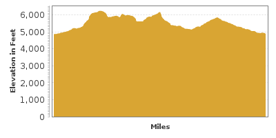
This scenic loop through Davis Mountains traverses an ancient volcanic playground, commonly referred to as the “Texas Alps.” The loop encompasses the highest town in Texas, Fort Davis, and the tallest peak in the Davis range, Baldy Peak sitting proudly atop Mount Livermore at 8,378 feet. Dramatic elevation changes, and a hard-scrabble landscape of incredibly adapted wildlife and plants create stunning beauty.
The scenic drive begins in Fort Davis, which you can reach either by taking exit 209 from I-10 and heading south on TX-17 for 31 miles or heading north on TX-17 from Marfa. Stop at the Marfa Lights Viewing Station (A3). The lights, best seen at night are a mystery with a variety of explanations from UFO’s, magnetic energy, military experiments or headlights in the distance.
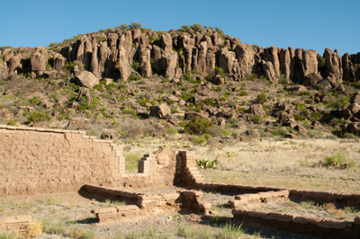
Before setting out for the drive, explore the Fort Davis National Historic Site (A1). Built in 1854 by the US Army to protect emigrants, freighters, mail coaches and travelers on the San-Antonia-El Paso Road and Chihuahua Trail from being attacked by Comanches and later, Apaches, this is one of the best-preserved examples of 19th-century frontier forts. There are interpretive displays, museum and book shop and the opportunity to experience the daily routine of a soldier replete with bugle calls and an 1875 dress retreat parade. There is a small fee per person to enter and children under 15 are free.
Heading west on TX-118, the road climbs the Limpia Canyon and offers expansive views of volcanic outcroppings, Limpia Creek and scattered brush, agave, cactus and juniper clinging to the rolling hills. You soon enter Davis Mountains State Park (H1). Cooler temperatures and higher rainfall allow for denser vegetation including ponderosa and piñon pine, oak and juniper trees, an ideal habitat for the canyon treefrog, black-tailed rattlesnake, mule deer, rock squirrels and an array of birds. Developed between 1933-1935 as a Civilian Conservation Corps (CCC) project, the park now offers camping, an adobe lodge, interpretive programs and 4 miles of hiking trails, two of which connect to the Fort Davis National Historic Site and several within the Limpia Canyon Primitive Area. The park also features day and overnight equestrian use and star-gazing after the Park closes on Skyline Drive. There is a small entrance fee, per-person over 13.
After a few miles, the road travels through classic Texas grassland with Mount Livermore and Mount Locke clearly visible. In a few miles, you will pass the peak of Mount Locke, and you should consider a side trip on SR-78 to the summit and the W. J. McDonald Observatory (A2). One of the leading astronomical research facilities in the world, it is also one of the only places that offers public access to research-class telescopes. At sunset, take in one of the public Star Parties, held every Tuesday, Friday, and Saturday, which are great for all ages. There are many other programs offering different levels of discussion for amateur or professional. Reservations can be made online and many programs fill up months in advance, so plan accordingly.
Heading west along the Elbow Canyon rim, the mountains in the distance are gorgeous. As you continue, the landscape changes to high desert with juniper and piñon.
Stop at Madera Canyon Roadside Park for superb views and hiking. The moderate 2.4-mile round trip loop Madera Canyon Trail offers a glimpse into the unique sky island of The Nature Conservancy’s Davis Mountains Preserve. Be sure to have water, sunscreen and watch your step as venomous snakes make this area home. And always, Leave No Trace.
At the fork, head left onto TX-166 where the dry desert landscape continues and Sawtooth Mountain rises in the distance, its volcanic past clearly visible in the rocky, jagged outcroppings.
The road continues like a ribbon strewn on desert hills with Davis Mountains in the distance. The Davis Mountains are between 35 and 39 million years old and are some of the oldest volcanoes that stretch from Mexico to Montana.
After a while, the mountain peaks give way to endless skies and broad views far into Mexico. As the road veers eastward, it begins to climb out of the desert to grasslands and ranches until the scenic drive comes to an end in Fort Davis.
From Fort Davis, consider heading south on TX-17 towards El Camino del Rio and Ross Maxwell Scenic Drive.

Share
 | ||||||
| Sun | Mon | Tue | Wed | Thu | Fri | Sat |
|---|---|---|---|---|---|---|
