

Skyline Drive
Shenandoah National Park
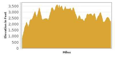
| Mileage | 103 miles (166 km) |
|---|---|
| DurationThe duration is an estimate of a one-way drive and does not include any stops or side-trips. | 3 hours |
| SeasonsThe seasons listed are the best seasons for this scenic drive. If Winter is not mentioned, the road may be closed during the winter. | All Seasons |
| Roadways | Skyline Drive |
| PassesSome of the adventures on this scenic drive require an admission fee that these passes cover. Please read the drive description for more information. | America the Beautiful Annual National Parks Pass 2024-2025 |
| ServicesThe cities or towns listed have either Food or Services such as gas, pharmacies, etc. | Front Royal, VA▼, Middletown, VA▼, Strasburg, VA▼, Flint Hill, VA▼, Washington, VA▼, Luray, VA▼, Syria, VA▼, Stanley, VA▼, more...Stanardsville, VA▼, McGaheysville, VA▼, Port Republic, VA▼, Crozet, VA▼, Waynesboro, VA▼, Afton, VA▼, Fishersville, VA▼, Lyndhurst, VA▼, Chester Gap, VA▼, Colonial Park, VA▼, Front Royal Junction, VA▼, Klines Mill, VA▼, Mineral Springs, VA▼, Monterey Orchards, VA▼, Overall, VA▼, Strasburg Junction, VA▼, Big Meadows, VA▼, Oaks of Shenandoah, VA▼, Massanutten, VA▼, and Barnes, VA▼ |
| Rating | 4.0 average from 82 votes |
| My DrivesTrack your favorite scenic drives by selecting those which you want to take and those that you have taken. Using your free account, simply sign in and select My Drives. | |
| Share |

Our free Road Trip Planner will reverse the route and include the places of interests. Click the “Add to Road Trip” above to start planning your next road trip.
Send this link to your phone. Standard text messaging rates apply.
() -Get directions from your start address to the beginning of and including this scenic drive. Choose either an alternate ending or same as start.
Have more destinations? Use our free Road Trip Planner to completely plan your adventure. Click the “Add to Road Trip” above to start planning your next road trip.
Get a Park Pass
Natural areas along this route require an entrance fee used to protect and maintain our most scenic treasures. Save time by purchasing your forest passes before you go.
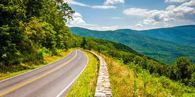
Skyline Drive is one of the best known scenic drives in Virginia and for good reason. Traveling through Shenandoah National Park and along the crest of the Blue Ridge Mountains, it offers sensational views of gently rolling hills to the east and the rich agricultural valley to the west. With two peaks over 4,000 feet, waterfalls, lush stream hollows, and a wide range of recreation opportunities, discover a world rugged, yet serene.
The Shenandoah National Park came into being in 1926. Years of deforestation making way for hunting, cropland, and pastures for grazing sheep and cattle damaged the region. Returning the land to its natural state was a priority and today 95 percent of the region is reforested. Skyline Drive began construction in 1931, a project approved by Herbert Hoover in hopes of stimulating the economy, and completed 8 years later. The ruins of cabins and farm buildings are testament to the history of the people that lived here and over 340 structures in the park are listed on the National Register of Historic Places.
Much of the Skyline Drive parallels the Appalachian Trail, the world’s longest marked trail at 2,175-miles, which travels from Maine to Georgia. There are several roadside access points which allow you to explore as little or as much of the 101 miles that pass through the park.
The scenic drive is described beginning in Front Royal and traveling to Rockfish Gap. You can reach Front Royal from exit 6 on US-66 and traveling south on US-340. Shenandoah National Park and Skyline Drive will be on your left after driving through Front Royal. The Shenandoah National Park does charge an entrance fee which is covered by the America the Beautiful Interagency Annual Pass. Take it slow as you travel the curves. The speed limit is 35-miles per hour, though with the surrounding panoramas and other travelers please be patient. RVs and campers are permitted, but be prepared to shift into low gear and clear Mary’s Rock Tunnel at 12 feet and 8 inches.
The road climbs Dickey Ridge displaying a patchwork quilt of farmlands to the east. Arriving at the first of seventy-five overlooks, the Shenandoah Valley Overlook (V1) offers expansive views of the valley, Shenandoah River, and Massanutten Mountain, which was used during the Civil War as a communication hub for both the Union and Confederate troops.
Just after the overlook is the Dickey Ridge Visitor Center (I1) where you can get maps and information about the park and trails, participate in a ranger-led activity and explore exhibits. Stretch your legs on the easy 1.2 mile loop Fox Hollow Trail nearby.
In 6 miles, views of the Blue Range emerge and if you’re visiting in spring, you will be welcomed by a rainbow of azaleas, dogwood, mountain laurel and redbud. The Range View Overlook (V2) offers stunning views of Blue Ridge, Stony Man Mountain, Gimlet Ridge, Massanutten and the Alleghenies.
Don’t miss stopping at the Hogback Overlook to observe the Shenandoah River as it snakes through the valley at the foot of Hogback Mountain.
The road twists down, and after crossing the US-211, heads through the 670-foot long Mary’s Rock Tunnel. Behold endless views of rolling hills and tremendous skies. It’s hard to believe all this beauty lies so close to an urban city.
If you have time, consider taking a detour on US-211 to visit the Luray Caverns (A2). Incredible rock formations drip from cathedral ceilings creating an underground world of glistening stone. Rocks that sing, sparkling lakes that mirror stalactites and fried egg shaped stone will amaze. There is an admission fee which includes a guided tour of the Luray Caverns, and entrance to the Car and Carriage Caravan and Luray Valley Museum.
Back on Skyline Drive, the Hazel Mountain Overlook (V4) features Shenandoah National Park’s third highest peak, Hazeltop.
Outstanding views await when you hike Mary’s Rock Trail from Meadow Spring Parking area. The moderately-difficult 2.8-mile round trip hike rewards with a 360-degree panoramic view. From this trailhead you will also find less difficult hikes through woods, passing streams, cascades and old homesites.
Continuing south, you soon arrive at the Pinnacles Overlook (V5). Admire 1 billion years of geologic history as layers of basaltic magma, greenstone, quartzite and limestone weathered by the elements, created Old Rag Mountain. Hiking Old Rag Trail is a popular but dangerous hike. Scrambling over boulders and picture perfect views are the reward for the extremely strenuous and steep hike which takes 7-8 hours round trip. Parking for Old Rag is near Nethers on VA-600. Do not attempt this hike unless you have experience and are well-prepared.
In about a mile, you arrive at the Stony Man Overlook (V7), where with the right squint, the 4,011-foot Stony Man Mountain resembles a person’s profile. From here, head up the Little Stony Man Trail to see ancient volcanic eruptions through a lush, green forest.
Heading south, you soon arrive in Skyland, the highest elevation of the Skyline Drive at 3,680-feet. Skyland is a resort town, which features lodging, dining, shopping and a wide range of recreation opportunities. Hike to the park’s second tallest peak and learn about the northern red oak, yellow birch, mountain ash and balsam fir that make up the forests on the easy 1.6-mile roundtrip loop Stony Man Nature Trail (H2).
Back on Skyline Drive, you will soon arrive at Whiteoak Canyon (H3). The 4.6-mile round-trip Whiteoak Canyon Falls Trail known as Shenandoah National Park’s “scenic gem” travels through a forest of hemlock, passing boulders, rock cliffs and a series of six waterfalls. The nearby Limberlost Trail is ADA accessible and passes the park’s oldest red spruce trees.
Crescent Rock Overlook (V8) provides a view of Shenandoah National Park’s tallest peak, but experience it up close with a stop at the Upper Hawksbill Parking Area and take the 1-mile hike to the summit of the 4,051-foot Hawksbill Mountain.
Heading south, the road unfolds beautiful views in all directions. At Dark Hollow Falls (H4), take the short, yet steep trail that leads to a dramatic 70-foot waterfall. This view inspired the great Thomas Jefferson to build his Monticello home in this region. Monticello (A3) is located just outside Charlottesville and has the only historic house in the United States on the United Nations’ World Heritage List. Consider a visit to the 5,000 acre plantation to learn more about the fascinating man who wrote the Declaration of Independence by taking US-64 at the end of this drive.
Moments afterward, you enter the region known as Big Meadows. Before establishing this National Park, the entire segment of road you have just traveled was once as barren as this. It is believed that these grassy and wildflower filled meadows were burned for centuries by Native Americans and early settlers to aid hunting and provide farmland. The National Park Service continues this ritual to maintain this historic site. Join a guided tour or explore on your own. Stop at the Byrd Visitor Center (I2) to learn about the history of the region. You will also find a gas station here.
Enjoy a classic view of Blue Ridge’s smoky peaks at Hazeltop Ridge Overlook (V10). The road parallels this amazing view for a few miles. Be sure to stop at the Bearfence parking area, where the moderately-difficult 1.2 mile loop Bearfence Rock Scramble trail brings you to the top of Bearfence Mountain (H6) and a jaw-dropping 360-degree panoramic view. It is not recommended if rocks are wet.
Continuing on Skyline Drive, you arrive at the South River Overlook (V11). Beautiful, almost undulating hills overlap with color. A 3-mile strenuous trail just south of here leads to the 83-foot South River Falls.
In need of services? The Loft Mountain Information Center is nearby with gas station, picnic area, restaurant and of course information.
After this, the road crosses US-33 and you arrive at Swift Run Overlook (V12), a crossing used for centuries. Many overlooks follow each offering its own little nugget of beauty. Particularly special is Big Run Overlook (V16) where rolling hills stretch along the vast horizon and the stream in the valley below. For the adventurous, hike the steep trail down to the valley and enjoy swimming or fishing.
From here, the road twists and turns along with grand views in every direction. Don’t miss the Crimora Lake Overlook (V17). This area was once the largest source of manganese in the United States.
The road twists as it descends until arriving in the town of Rockfish Gap where the scenic drive comes to an end. It is also where the Skyline Drive meets the Blue Ridge Parkway which we highly recommend.
Don’t forget that the Shenandoah National Park offers incredible opportunities for biking, horseback riding, swimming, fishing, wildlife viewing, informative ranger-led programs and more. Stay in the park camping or in one of the historic lodges.

Share
 | ||||||
| Sun | Mon | Tue | Wed | Thu | Fri | Sat |
|---|---|---|---|---|---|---|
