
Spirit Lake Memorial Highway to Mount St. Helens
Drive through the volcanic devastation of the 1980 eruption of Mt. St. Helens
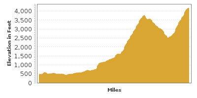
| Mileage | 51 miles (82 km) |
|---|---|
| DurationThe duration is an estimate of a one-way drive and does not include any stops or side-trips. | 2 hours |
| SeasonsThe seasons listed are the best seasons for this scenic drive. If Winter is not mentioned, the road may be closed during the winter. | Spring, Summer, and Fall |
| Roadways | Washington Highway 504 |
| ServicesThe cities or towns listed have either Food or Services such as gas, pharmacies, etc. | Castle Rock, WA▼ |
| Rating | 4.1 average from 86 votes |
| My DrivesTrack your favorite scenic drives by selecting those which you want to take and those that you have taken. Using your free account, simply sign in and select My Drives. | |
| Share |

Our free Road Trip Planner will reverse the route and include the places of interests. Click the “Add to Road Trip” above to start planning your next road trip.
Send this link to your phone. Standard text messaging rates apply.
() -Get directions from your start address to the beginning of and including this scenic drive. Choose either an alternate ending or same as start.
Have more destinations? Use our free Road Trip Planner to completely plan your adventure. Click the “Add to Road Trip” above to start planning your next road trip.
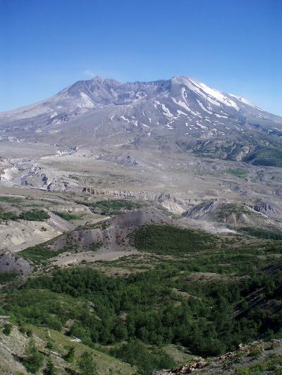
Once the fifth highest mountain of the Cascade Mountains, Mount Saint Helens erupted the morning of May 18, 1980. Not only are the facts and stories of the eruption itself fascinating, there is nothing like driving through the area today and seeing how nature has progressed since the eruption. This drive explores the west side of the mountain. Each side offers a unique perspective, and we recommend exploring the east and south sides if time allows.
This scenic drive through this area begins in Castle Rock and follows WA-504 east, mostly following the North Fork Toutle River to the Johnston Ridge Observatory. To reach Castle Rock, take exit 49 from I-5.
About five miles from Castle Rock, the Mount St. Helens National Volcanic Monument Visitor Center (A1) is on your right and is well worth a stop to learn about the eruption and its effects on the surrounding area. Outside the center is a beautiful, short trail with access to Silver Lake and its wetlands.
A little over five miles from the Visitor Center, you will reach the Toutle River which the road parallels for the remainder of the drive. During the eruption, the river became a mud flow as lahars poured vast amounts of sediment into the Toutle. Today, there are few signs of this though once you reach the North Fork Toutle River, the river’s walls reveal some of the mud.
Much of the land in this area is privately owned by timber companies, as is evident by signs indicating the dates that the forests were planted and when they will be harvested. The 1980 eruption was devastating to the forests, however, many helped revive the area by planting trees.
The Army Corps of Engineers built the Sediment Retention Structure (H1) in 1989 to stop the sediments from flowing downstream. Just before the Toutle River Bridge, turn right on Stewart Dam Road to the viewpoint. The hikes in this area bring you up close to the mud flow debris.
You may have wondered why some of the hills have very little growth, even after all these years. Ash-covered land lacks nitrogen and prevents vegetation from growing, however, grasses and clover are natural nitrogen generating plants and these have been planted in such areas.
Around milepost 24, Mount Saint Helens becomes visible and it is a spectacular sight. The Hoffstadt Bluffs Visitor Center (A6) is a great place to stop to look at the valley and Mount St Helens. Surprisingly, on cloudy or hazy days, you may not be able to see Mount St Helens at all. If you are lucky, you may see some wildlife, and as you continue the drive, keep an eye out for deer.
The Weyerhauser Forest Learning Center (A3) will enlighten you about the work being done to help nature recover from the eruption. Right outside the center is a viewing area of the valley, complete with binoculars and telescopes. You have a good chance of spotting herds of elks here.
Approximately twelve miles ahead is the Mount Saint Helens Science and Learning Center at Coldwater (A5), (formerly the Coldwater Ridge Visitor Center). This facility is open on weekends from May-October and features interesting interpretive displays, educational programs, guided hikes, field trips, camps and more. Interested in learning more on a guided Summit or Into the Crater Hike? Make reservations at least 1-year in advance.
Follow SR-504 to nearby Coldwater Lake. Located in the middle of the blast zone, this lake was formed when debris dammed the Coldwater Creek Valley after the eruption. The half-mile wooden boardwalk Birth of A Lake Trail allows for an accessible, leisurely stroll with glimpses of Mount St. Helens and Minnie Peaks.
Open May through October, the Johnston Ridge Observatory (A2) is at the end of the WA-540 and with no hiking at all, offers stunning views of Mount Saint Helens, its lava dome, crater, pumice plain and landslide deposits. Surrounding hillsides are strewn with tree trunks that lie like matchsticks. The visitor center provides a wealth of fascinating information on the 1980 eruption, current regeneration of plant and animal life, and the latest in volcanic science. Don’t miss the informative wide-screen theater presentations, interpretive displays and variety of ranger-led talks and guided walks. There are a number of hikes for every skill level. Take the Boundary Trail which allows you to get up close and personal with Mount Saint Helens, and if you’re up to it, we highly recommend continuing to Harry’s Ridge Viewpoint. Along this section you’ll discover a landscape of hummocks, a richer array of plant life with brightly colored wildflowers and huckleberry bushes, before arriving at a jaw-dropping view of Spirit Lake and Mount Adams proudly looming in the background. The roundtrip hike is almost 8 miles, but a rolling elevation gain of less than 500 feet makes it a moderate excursion, and the short cliff-hugging section is fun too. Even if you don’t go all the way — we do recommend walking part of Boundary Trail which has benches perfectly placed amid majestic views.
On your way home, follow the road back the same way you came, stopping at turnouts and points of interest you may have missed to fully enjoy this beautiful, mountain scenic drive.

Share
 | ||||||
| Sun | Mon | Tue | Wed | Thu | Fri | Sat |
|---|---|---|---|---|---|---|
