

Bighorn Canyon Loop
Scenic Central Wyoming
| Mileage | 297 miles (479 km) |
|---|---|
| DurationThe duration is an estimate of a one-way drive and does not include any stops or side-trips. | 4 hours, 31 minutes |
| SeasonsThe seasons listed are the best seasons for this scenic drive. If Winter is not mentioned, the road may be closed during the winter. | Spring, Summer, and Fall |
| Roadways | US Highways 14, 14A, 16, and 20 |
| ServicesThe cities or towns listed have either Food or Services such as gas, pharmacies, etc. | Cody, WY▼, Powell, WY▼, Lovell, WY▼, Greybull, WY▼, Pahaska, WY▼, Wapiti, WY▼, and Lone Tree Crossing, WY▼ |
| Rating | 3.8 average from 49 votes |
| My DrivesTrack your favorite scenic drives by selecting those which you want to take and those that you have taken. Using your free account, simply sign in and select My Drives. | |
| Share |

Our free Road Trip Planner will reverse the route and include the places of interests. Click the “Add to Road Trip” above to start planning your next road trip.
Send this link to your phone. Standard text messaging rates apply.
() -Get directions from your start address to the beginning of and including this scenic drive. Choose either an alternate ending or same as start.
Have more destinations? Use our free Road Trip Planner to completely plan your adventure. Click the “Add to Road Trip” above to start planning your next road trip.
Experience the Wild West in this drive that starts west of Cody where Buffalo Bill (William F. Cody) built the Pahaska Tepee and loops around the Big Horn and Shell Canyons and through the cliff-hanging mountain drive built in the early 1900s. Starting west of Cody on US-14, the drive heads through the Shoshone National Forest which is home to more than 2 million acres of wilderness.
East on US-14, head through amazing volcanic formations. Stop and marvel at Holy City, a unique rock formation that resembles an ancient city. You will soon arrive at the Wapiti Ranger Station (I1), the oldest ranger station in the United States. Stop here for some information about hikes and to enjoy the scenery.
Continuing east, in 19-miles you will arrive at Buffalo Bill State Park (H1), recognized by the Buffalo Bill Reservoir. Stunning scenery of the Shoshone Canyon, Logan Mountain and the Shoshone Rivers make this a great spot for boating, windsurfing, and hiking. Take advantage of the turnouts capture the many stunning vistas.
A few miles after the park, you arrive in Cody. Visit the Buffalo Bill Historical Center (M1) which presents artifacts and information about the Wild West. Explore the original downtown and stroll through the current downtown which features quaint shops and restaurants all reminiscent of the Wild West.
As you leave Cody, this drive continues on US-14A providing sweeping views of the surrounding valleys. In some 46 miles from Cody, you arrive in Lovell, where the scenery will start to change to the rolling hills ahead. Visit the Pryor Mustang Center (M2) to experience wild horses still roaming free.
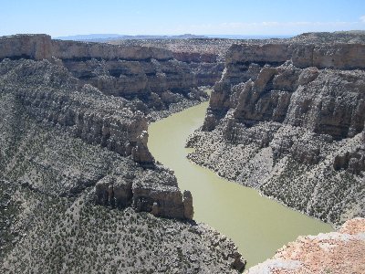
Just west of the Pryor Mustang Center is the Bighorn Canyon Visitor Center (I3) where you can get information about the Bighorn Canyon National Recreation Area (H2). There are a few hikes in the area that bring you to the rim of the canyon, and a stop at the visitor center will help find the best hike for you. Picnic here, taking advantage of the green grass and shaded areas before heading on.
To truly experience the Bighorn Canyon, head north on WY-37 into Montana. Dry climate, immense rocky outcrops and the lack of trees are a striking change and awe-inspiring. Following the road is the Bad Pass Trail which was originally created by Native Americans. Get a close up view of the canyon by heading north into Montana and stopping at the Devil Canyon Overlook (V1) where the earth drops about 1,000 feet below. The views are outstanding as you experience desert-like surroundings, wildlife used to harsh conditions and millions of years of erosion creating unsurpassed beauty. Many hike trailheads are near here so be sure you made that stop at the visitor center as they are not easily seen from the road. You can also experience the canyon from the water by taking a boat tour.
Heading east on US-14A, this section of the drive is a cliffhanger modeled after the Alps. The drive will soon reach Forest Road 12, where a 3-mile side-trip on a dirt road followed by a 3-mile round trip hike will bring you to Medicine Wheel National Historic Landmark (A1), where you will see a fascinating 80-foot diameter limestone circle with radiating spokes set into the landscape that was built and is held sacred by local Native American tribes. It is believed to have been created to track the solstice.
A short side-trip on Sheep Mountain Road will bring you to the 200-foot drop of the Porcupine Falls and further up the road, is one of the tallest waterfalls in the area, the 600-foot drop of the Bucking Mule Falls.
Continuing east, you will see the Bighorn Mountains ahead. From here on a clear day, you can see deep into Montana and the snow-capped Rockies. Soon you will arrive in Burgess Junction where it is quite possible that you will see elk and moose grazing. This scenic drive heads south and back west on US-14.
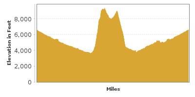
For the next 10-miles, the drive will climb up 8,860 feet of elevation to Granite Pass and then descend through Shell Canyon. On the way down, stop at Shell Falls (H4) which gushes more than 3,600 gallons of water per second down the 120-foot drop.
The drive heads west until it ends in Cody in 79-miles. From here, consider heading to Yellowstone National Park or head east to the Black Hills.

Share
 | ||||||
| Sun | Mon | Tue | Wed | Thu | Fri | Sat |
|---|---|---|---|---|---|---|
