
Malibu to Lompoc
Along the Pacific Coast Highway
| Mileage | 116 miles (186 km) |
|---|---|
| DurationThe duration is an estimate of a one-way drive and does not include any stops or side-trips. | 2 hours, 5 minutes |
| SeasonsThe seasons listed are the best seasons for this scenic drive. If Winter is not mentioned, the road may be closed during the winter. | All Seasons |
| Roadways | California Highway 1, and US Highway 101 |
| ServicesThe cities or towns listed have either Food or Services such as gas, pharmacies, etc. | Agoura Hills, CA▼, Malibu, CA▼, Thousand Oaks, CA▼, Camarillo, CA▼, Port Hueneme, CA▼, Oxnard, CA▼, Ventura, CA▼, Santa Paula, CA▼, more...Oak View, CA▼, Rancho Cucamonga, CA▼, Carpinteria, CA▼, Summerland, CA▼, Santa Barbara, CA▼, Solvang, CA▼, Buellton, CA▼, Santa Ynez, CA▼, Lompoc, CA▼, Los Alamos, CA▼, Ojai, CA▼, Hollywood by the Sea, CA▼, Oxnard Beach, CA▼, Hollywood Beach, CA▼, Oxnard Shores, CA▼, Santa Barbra, CA▼, Los Cruces, CA▼, and Ballard, CA▼ |
| Rating | 3.9 average from 94 votes |
| My DrivesTrack your favorite scenic drives by selecting those which you want to take and those that you have taken. Using your free account, simply sign in and select My Drives. | |
| Share |

Our free Road Trip Planner will reverse the route and include the places of interests. Click the “Add to Road Trip” above to start planning your next road trip.
Send this link to your phone. Standard text messaging rates apply.
() -Get directions from your start address to the beginning of and including this scenic drive. Choose either an alternate ending or same as start.
Have more destinations? Use our free Road Trip Planner to completely plan your adventure. Click the “Add to Road Trip” above to start planning your next road trip.

This drive begins on CA-1 on the east side of Malibu Creek Bridge at the historic Malibu Sport Fishing Pier. The name Malibu is derived from the Chumash word “Humaliwo” meaning “the surf sounds loudly” and throughout this drive you will be treated to the rhythmic music of the ocean. The Pier was originally built in 1905 to transport agricultural produce, building materials and basic supplies to and from the colony. Today, it hosts a variety of businesses where you can rent kayaks, surfboards and paddle boards, go on a charter fishing boat or whale watching excursion, or indulge in the myriad of beach-side dining and shopping opportunities.
To the west of the Pier is Malibu Lagoon State Beach (W1). Also known as Surfrider Beach, it is world-renowned for its three-point break that delights surfers with exhilarating 300-yard rides on a single wave. On the west side of Malibu Creek Bridge, there are picnic tables and a natural area, excellent for bird watching. The Southern California saltwater marsh, known as the Malibu Lagoon is actually an estuary where Malibu Creek meets the Pacific Ocean. Explore stunning water and cliff views, pelicans, egrets, tide pools and more on the Malibu Beach Trail. There is a fee for vehicle parking, no charge to walk or bike in.
The Malibu Lagoon Museum (M11) display artifacts and exhibits depicting local history from the early Chumash Indian era, gentleman ranching, and the pivotal development of the surfing era. There are docents available for tours who recant many interesting local legends. Visiting the museum and grounds is free. Learn more about Malibu history and the Rindge family at the nearby Adamson House. Part of the Malibu Lagoon Museum, this National Historic Site features original furnishings and elaborate ceramic tiles designed by Malibu Potteries — characteristic of Spanish Colonial Revival architecture. There is a fee to enter the Adamson House and there are no house tours when raining.
We can’t mention Malibu without commenting on the strip known as the Malibu Colony. These star-studded beachfront properties are owned by Barbra Streisand, Tom Hanks, Dustin Hoffman, Robert Redford, Goldie Hawn, Pierce Brosnan and scores of other Hollywood stars. Don’t expect to drop in for tea as this area is well guarded, though stars have been spotted walking around town. It is an unwritten local rule that the famous are left alone.
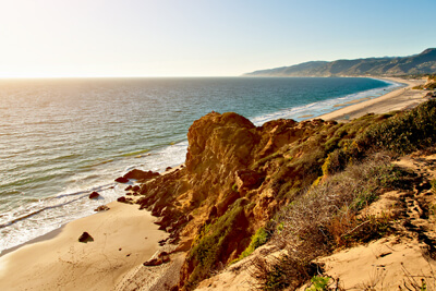
Situated on a promontory is Point Dume State Park (W5). Find parking at the top of the cliff (which is very popular with rock climbers) and walk down or try your luck by the beach on the side of the road. This is a good surfing spot due to the shorter sand shelf, creating waves with short duration and high impact. Enjoy swimming, scuba diving or immerse yourself in the incredible views and rocky cove. Have binoculars in hand to gaze upon dolphins and gray whales during migration from December to March. Hiking trails can be found at Point Dume Natural Preserve which is at the end of Westward Beach Road.
Heading north you will encounter the most popular beach spot in Los Angeles County, Zuma Beach (W6). Two miles of soft sandy beach are replete with sun bathers, swimmers, surfers and all the quirky stereotypes that make Malibu, Malibu. The life-guarded beach is considered one of the healthiest in the county for its clean water conditions. There are volleyball courts on the sand, a playground, snack bar, and a 2.5-mile biking and walking path. Several top surfing events are held here each year and it is also one of the best spots for kite-surfing thanks to the gust of afternoon winds. Parking on the highway is free and there is a paid parking lot. The beach is crowded on weekends, but relatively quiet on weekdays.
Another popular and picturesque beach can be found at Leo Carrillo State Beach (W7). Enjoy skin diving, surfing, swimming, exploring tidepools and the only sea cave on the entire Santa Monica mountain range. The small Visitor Center features interpretive displays and outdoor nature programs. Year-round coastal camping is available and back-country hiking can be found inland.
Continuing north on the Pacific Coast Highway you’ll arrive at Point Mugu State Park and Natural Preserve (W8), featuring five miles of shoreline with sandy beaches, rocky volcanic bluffs and sand dunes. There are 70 miles of hiking trails which include rugged hills and uplands, two river canyons and a grassy valley filled with sycamore and oak trees. The Sycamore Canyon Trail is a 6.5-mile round trip hike with a 200 foot elevation gain though it’s not necessary to walk the entire loop to appreciate the stunning beauty. If you’re here in autumn, you will be bedazzled by the flurry of millions of monarch butterflies that spend time here during their migration south. Giant sycamore trees are the main attraction and a small grove almost midway is a great place for a picnic, birdwatching or turn around. As with all hikes remember to have the 10 essentials. This is also a popular camping destination.
Soon you will pass Mugu Lagoon on the left, the largest undeveloped coastal wetland in Southern California, and a premier spot for birdwatching. Just ahead is a military airbase, the Naval Base Ventura County Complex.
Miles of flat fields growing beets, lima beans, strawberries, avocados, lemons, cauliflower, broccoli, and other vegetables lie ahead. For those of us far from agricultural lands it’s nice to see where our food comes from and workers in the fields planting and picking.
From here CA-1 proceeds to the turnoff to Port Hueneme (pronounced “why-nee-mee”). This is the only deep water port between San Francisco and Los Angeles and is home to the Navy Pacific Seabees and the U.S. Naval Construction Battalion Center.
Port Hueneme has facilities for large ships, and sport fishing and charters can be arranged here. Take the exit Channel Island Boulevard to the Port and then exit for Ventura Road which leads to Port Hueneme Beach Park and Pier. The expansive beach is fully-equipped and offers views of the Channel Islands and fishing off the pier.
At the entrance to Port Hueneme Harbor is the Point Hueneme Light. This 1940 Art Deco style tower and fog signal lighthouse still uses the revolving fourth-order 1889 Fresnel lens moved from the previous lighthouse. The lighthouse is owned and operated by the United States Coast Guard and members of the Auxiliary are in charge of tours and open houses which are available on the third Saturday of the month from February through October between 10am and 3pm. Admission is free. You can access the lighthouse building by strolling the one-half mile Lighthouse Promenade from Port Hueneme Beach Park (W9) alongside the Port fence.
Head back to Channel Islands Boulevard to the Channel Island Harbor where thousands of small boats are moored. The harbor is buzzing with dining and shopping opportunities, a Sunday farmer’s market, beaches and departure for charter cruises, kayaking, scuba diving, snorkeling and whale watching tours. The tall ship Bill of Rights and the Talofa are moored here and tours and sailing trips are available. Visit the Ventura County Maritime Museum (M6) which houses one of the largest collections of ship models in the US, world class maritime paintings and other maritime artifacts. Enjoy sun-drenched white sands at Hollywood Beach on the ocean side of the harbor or head north on Harbor Blvd. to Oxnard State Beach (W10). Along with spectacular beach, there are rolling lawns and a paved path perfect for strollers, bikes and jogging as well as an accessible beach ramp.
Access to the east side of the harbor from Channel Islands Boulevard is via Victoria Avenue which leads to Island View Avenue and the stunning multi-million waterfront mansions and post-war homes adjacent to Silver Strand County Beach. At the end of the road is Point Hueneme and La Jenelle Park (H2). The cruise ship La Janelle ran aground here on April 13, 1970 and was stuck in the sand offshore for many years. Now parts of the ship are embedded in the breakwater at this location, making this a popular dive spot. Artifacts rescued from the wreck, including the steering station, can be seen in the Ventura County Maritime Museum.
From Oxnard, CA 1 joins the 101 Freeway at what is known as the Wagon Wheel Junction and this drive continues northward.
Beginning at the junction of CA-126 and US-101 you enter the city of Ventura. Along with average daytime temperatures of 70 degrees year-round, Ventura is a draw for its vibrant arts community, distinctive shops, antiques, tantalizing dining and historical sights. The historic downtown is pedestrian-friendly and much can be explored on foot. More information and self-guided walking tour maps are available at the Ventura Visitor Center (I2). Don’t miss the San Buenaventura Mission (A1), the ninth mission founded by Father Junipero Serra. Completed in 1809, discover the beauty of the high altar, original Indian art, two original wooden bells and church doors as well as stunning gardens. At the Ventura County Historical Museum (M7) enjoy a fascinating look back at life in the region from prehistory to present day. Exhibits include historic and contemporary art, one-fourth scale figurative sculptures of famous individuals from world history, baskets and artifacts of the Chumash Indians and more. There is a small charge to enter which also includes the Museum of Ventura County Agriculture Museum (M10) in Santa Paula.
The beautifully designed San Buenaventura State Beach (W12) offers all the popular beach activities, volleyball, hiking and is a very safe swimming spot due to the gentle slope of the sand to the ocean. Emma Wood State Beach (W13) is another great stop — and offers great fishing and camping for groups, self-contained vehicles, and primitive RV sites. A bike path connects this park to Ventura.
From the Seward Street exit, drive down to Ventura Harbor Village for a taste of the oceans offerings. One of the top 10 fish offloading harbors in the US, watch the action and then dine in one of the many restaurants serving fresh seafood. Stroll by local shops and try to view all 29 of the colorful Ventura Harbor Tile Murals created by local artist Michel Petersen. Here you can rent kayaks, take a harbor cruise to see whales, sea lions, pelicans and dolphins, whole or half day Channel Islands excursions, or immerse yourself literally by diving and snorkeling.
Just 11 miles offshore is the extraordinary Channel Islands National Park (H3) which encompasses five of the eight Channel Islands. Due to the isolation and position at the confluence of two major ocean currents, there is an incredible diversity of life and over 2,000 plants and animals, 145 of which are found nowhere else on earth. There are a variety of hikes and kayaking trips which explore the finest remnants of the coastal Mediterranean-type ecosystem in America. Visit the park via a boat ride or flight, both of which require advance reservations. Consider a stop at the Channel Islands National Park Visitor Center (I1) before heading out for interpretive exhibits, information on how to get to the islands, guided tours and camping.
The Olivas Adobe Historical Park (H5) offers a look back to ranching and Latino history. Built between 1847-49 by wealthy Don Raymundo Olivas on his 4,700-acre Rancho San Miguel, the two-story hacienda is on the National Register of Historic Places and visitors can learn more through period furnishings and beautiful gardens. The grounds are open daily free and there are docent-led tours on the weekend for a small charge. In summer, the hacienda is the spectacular setting for the Music Series, Summer Under the Stars.
Traveling north of Ventura on US-101 you arrive at CA-33 to Ojai with a turnoff to Lake Casitas (W14) on CA-150. Consider a side trip here to fish for largemouth bass, rainbow trout crappie red-ear sunfish, and more in the well-stocked lake. There are many picnic spots, and Picnic Area #1 marks the beginning of a 3-mile round trip paved trail perfect for cycling, jogging or leisurely stroll. There is a day use vehicle parking fee. Stay longer at one of the more than 400 camping sites that accommodate tents campers and RVs.
CA-150 leads back to US-101 which then passes above the Seacliff area. Exiting the freeway here hugs the shoreline and then leads back to US-101. Next up on US-101 is Rincon Beach (W15). This is a well-known surfing spot, especially in winter and watching the weaving dance of surfers is mesmerizing. Enjoy great swimming, body boarding, fishing, and picnicking.
Continuing north on 101 you arrive at Carpinteria State Beach (W2), known to have “the safest beach in the world” due to a surf that breaks far out so there’s no undertow. Enjoy expansive sandy beach, tidepools rich with colorful starfish, sea anemones, sea urchins and more to explore. Hike the Carpinteria Beach Trail for spectacular views. Heading to Harbor Seal Preserve is a 2.5-mile round trip — and if you’re there from December to May you can observe the colony from an area above the beach as this section is closed to humans.
Continuing on to the Carpinteria Bluffs which makes for a 4.5 mile round trip. Nearby, the Carpinteria Salt Marsh Nature Park preserves one of California’s few remaining coastal estuaries. Birdwatchers will find much to explore at this 230-acre salt marsh, spotting green herons, belted kingfishers and endangered long-billed curlews and snowy plovers. Learn more on one of the free docent-led tours every Saturday at 10 am.
Back on US-101 approaching Montecito, you may want to take time to visit a most unusual garden. Created and designed by Madame Ganna Walska, Lotusland (A8) is a 37-acre estate featuring unique subtropical and tropical plants from around the world. Marvel at over 170 types of aloe, explore the Cacti and Euphorbia Gardens, Japanese Garden and Topiary Garden with a functioning topiary clock and the whimsy of 26 animals and geometric shapes. The Water Garden features the namesake — Lotus and other water plants. Because Lotusland is a public garden operating in a private, residential neighborhood, advance tour reservations are required to visit. There is an admission fee.
As you enter Santa Barbara, take the Cabrillo Boulevard (CA-225) exit from US-101 to drive to the waterfront attractions. The Andree Clark Bird Refuge (A7) is first along the road. This wetland attracts waterfowl both wild and domestic. Exquisite views are enjoyed from the paved path for walking or biking around the perimeter of the refuge.
On the west side of the refuge and across from East Beach (W4) is the Santa Barbara Zoo (A2). The zoo features 160 species of animals on 30 acres and it’s worth planning on at least half a day to explore it all. There are two rare Amur leopards, Channel Island foxes, Chilean flamingos, Asian elephants, giraffes, lions, river otters, Humboldt penguins and more as well as a barnyard petting zoo, train ride and Dentzel carousel. East Beach is one of Santa Barbara’s most popular, and along with gorgeous ocean views, palm-shaded lawns, pristine sand, it is host to volleyball tournaments and festivals. Enjoy swimming, basking, or just relaxing with the sound of the crashing waves.
Continue down Cabrillo Blvd. where every Sunday until dusk is the Santa Barbara Arts and Crafts Show. Established in 1965 by local artists, you can peruse art of varying media and meet the artists and at times see them at work. Further ahead, where State Street meets Cabrillo Blvd. is the entrance to Stearns Wharf (A5). The wooden wharf is more than 130 years old and at one time served cargo and passenger ships. Now a popular tourist destination, there are many restaurants, shops and local wine tasting on the pier. Many private yachts, fishing boats, excursion and sightseeing boats are moored here.
At the Ty Warner Sea Center (A9) get close up and personal with sea creatures. A tidepool touch tank will acquaint you with starfish, anemones, sea urchins, hermit crabs, and more. Or you can examine marine life with microscopes, test ocean water, or crawl through a tunnel inside a 1500 gallon surge tank. This fun and educational destination is part of the Santa Barbara Museum of Natural History. Stroll along the breakwater on the Flag Walk and search for passing whales.
The Santa Barbara Maritime Museum (M8) houses artifacts from the region’s maritime past. Navigate the history of local shipwrecks, oil exploration, island ranching and naval military through exhibits, artifacts and models. The exhibit “Surf’s Up” explores surfing history in a theater shaped like a ship’s hull, experience an audio-visual seagoing experience. The museum is open every day except Wednesday.
Head back to State Street and drive into downtown to visit El Presidio De Santa Barbara State Historic Park (A3), featuring some of the oldest buildings in California, including La Canedo Adobe and the second oldest structure in California, El Cuartel. This was the last in the chain of military posts built by the Spanish in 1782 and now preserves the archaeology and history of the cultural mix of Chumash, Spanish, Mexican, Euro-American, Chinese and Japanese settlers.
Nearby, the Alice Keck Park and Memorial Garden (H4) delights with winding walkways leading to flower gardens, trees, a gazebo, bridges, and ponds with Koi and turtles. The sensory garden has audio posts and Braille signs for the visually impaired.
Santa Barbara offers so much to do and if your schedule allows, consider an overnight stay to enjoy the diverse activities, shops and restaurants. The most well-known attraction is the Santa Barbara Mission (A4) built in 1786. Known as the “Queen of the Missions” for its elegant architecture and twin bell towers, this is the 10th California Mission and one of the few buildings to survive the 1925 earthquake. Stroll the beautiful gardens and museum. Daily tours are available for a small charge.
Continue up the road to the Santa Barbara Museum of Natural History (M4). Explore fascinating specimens, and exhibits on anthropology, vertebrate and invertebrate biology, geology, archeology, and paleontology. Experience the wonders of the night skies at the planetarium and astronomical observatory. Outside, observe a full skeleton of a blue whale, an ethnobotanical garden and butterfly pavilion.
North of the museum with views of the Santa Ynez Mountains and Pacific Ocean, is the Santa Barbara Botanic Garden (H1) featuring 40 acres of California’s native flora. The herbarium is composed of over 14,000 specimens of central coast plants. There is a garden shop and a retail nursery.
Traveling north again on US-101 is the town of Goleta. Railroad buffs will want to visit the South Coast Railroad Museum (M9) to see a restored 1901 Southern Pacific Railroad Depot and ride the Goleta Shortline miniature train or handcar. There is a bay-window caboose on site and collections of railroad artifacts and memorabilia as well as an HO model train layout.
From Goleta our trip takes us north again, along the shoreline where you will see many oil rigs out in the Santa Barbara Channel. If you need a fix of sunny beach you will come upon two. El Capitan Beach State Park (W16) features magnificent views, tidepools, swimming surfing and if you’re lucky, the chance to spot dolphins. Refugio State Beach (W17) offers a stunning palm tree-lined beach with lifeguards, coastal fishing, camping, guided kayak tours. Both beaches offer free use of specially-designed wheelchairs to access the beach and camping. Continuing on, there is a rest stop at Gaviota Pass just before entering the tunnel through the mountains. Once a footpath, then stagecoach route, this road is flanked by towering rocky cliffs. Shortly after coming out of the tunnel you will find the turnoff for CA-1 to Lompoc.
Lompoc is renowned for its flower fields. Explore the colorful history of the region through murals painted on many of the commercial buildings downtown. Pick up a map of the mural route at the Lompec Valley Chamber of Commerce. More than half of the world’s flower seeds are grown in Lompoc and a scenic side trip on the Valley Flower Drive (T1) dazzles as fields of color scream for your attention. Head west on Ocean, right on Bailey and once you get to Central Ave., traverse up and down the streets until Union Sugar Road. Blooming begins mid-May, peaking in June until August. The last weekend in June hosts the vibrant Lompoc Valley Flower Festival.
A must see is La Purisima Concepcion de Maria Santisima (A6). Founded in 1787, ten of the original buildings have been fully restored and authentically furnished. Explore the historic aqueduct and water system, five-acre garden with native plants and animals including turkeys, burros, sheep, goats, horses, and longhorn cattle. Docents dressed in period costume tend the animals and perform farming chores and traditional mission life such as pottery weaving and leatherwork. There is also a picnic area and 25 miles of hiking trails.
From the mission CA-246 will bring you back to US-101, where our scenic drive ends. From here, consider heading north on US-101 to San Luis Obispo, where the Big Sur Scenic Drive begins.

Share
 | ||||||
| Sun | Mon | Tue | Wed | Thu | Fri | Sat |
|---|---|---|---|---|---|---|
