
Silver Thread Scenic Byway
Discover Colorado's Mining History
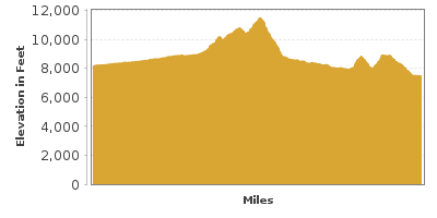
| Mileage | 114 miles (184 km) |
|---|---|
| DurationThe duration is an estimate of a one-way drive and does not include any stops or side-trips. | 4 hours, 25 minutes |
| SeasonsThe seasons listed are the best seasons for this scenic drive. If Winter is not mentioned, the road may be closed during the winter. | All Seasons |
| Roadways | Colorado Highway 149 |
| PassesSome of the adventures on this scenic drive require an admission fee that these passes cover. Please read the drive description for more information. | America the Beautiful Annual National Parks Pass 2024-2025 |
| ServicesThe cities or towns listed have either Food or Services such as gas, pharmacies, etc. | South Fork, CO▼, Creede, CO▼, Lake City, CO▼, Powderhorn, CO▼, Gunnison, CO▼, and Mountain Meadows, CO▼ |
| Rating | 3.8 average from 13 votes |
| My DrivesTrack your favorite scenic drives by selecting those which you want to take and those that you have taken. Using your free account, simply sign in and select My Drives. | |
| Share |

Our free Road Trip Planner will reverse the route and include the places of interests. Click the “Add to Road Trip” above to start planning your next road trip.
Send this link to your phone. Standard text messaging rates apply.
() -Get directions from your start address to the beginning of and including this scenic drive. Choose either an alternate ending or same as start.
Have more destinations? Use our free Road Trip Planner to completely plan your adventure. Click the “Add to Road Trip” above to start planning your next road trip.
Get a Park Pass
Natural areas along this route require an entrance fee used to protect and maintain our most scenic treasures. Save time by purchasing your forest passes before you go.
The byway weaves through the 2 million-acre Rio Grande National Forest as it travels from South Fork to the Blue Mesa Reservoir in Curecanti National Recreation Area. Behold dramatic mountain scenery, tranquil forests, alpine lakes and options galore to get outdoors and play.
South Fork is the gateway to the Silver Thread Scenic Byway. Surrounded by a landscape millions of years in the making, this area was home to the Ute people, and then prospectors who came to find make their riches mining silver and logging. Today, it’s a premier vacation destination. Stroll among quaint boutiques, coffee shops, and restaurants, and take advantage of the bounty of recreation options. Whether you’re interested in a guided adventure or want to set out on your own, outfitters can help, from fishing trips, Class II-IV white-water rafting on the Rio Grande, biking, horseback riding, kayaking, jeep or snowmobile rentals. How about downhill skiing amid jaw-dropping views of the San Juans? Head south on US-160 to Wolf Creek Ski Area (H4). Boasting “the most snow in Colorado”, you’ll also find a Nordic Track, snowboarding, ski lessons, restaurants and lodging. Stop at the South Fork Visitor Center (I1) for local and regional information. On Saturday and Sunday from June to September, don’t miss the South Fork Farmers Market. On the 1st and 3rd weekend of each month there is also an Antique Flea Market. In town, and dotted throughout the drive are hotels, cabin rentals, lodges, ranches, RV and tent campgrounds.
The byway begins in South Fork heading north on CO-49. Cast your line fly-fishing at Coller State Wildlife Area (H2). Also a stop on the Colorado Birding Trail, observe Yellow Warblers, Cordilleran Flycatcher, Green-tailed Towhee, and wildlife such as elk, deer, and coyote. There is seasonal hunting.
The town of Wagon Wheel Gap was the first stage stop between South Fork and Lake City. Learn more at the pull-out/rest stop which features an interpretive facility, as well as a boat ramp and fishing. Nearby are privately-owned hot springs. Access only permitted with overnight stay at the resorts.
In Creede, visit the Underground Mining Museum (M2). Literally underground, experience fascinating and educational displays on the history, equipment and methods of silver mining which was the region’s main industry until 1985. Take a guided tour led by actual miners, or explore self-guided via recorded information for each attraction. The Creede Historic Museum (M5) is located in the Old Denver and Rio Grande Railroad Depot. This small gem, features exhibits, hundreds of artifacts and photos. Or enjoy a performance at the Creede Repertory Theater (A1). The laid back downtown is lined with historic buildings, outdoor sculptures and murals. Discover eclectic restaurants, bars, cafés, lodging and plentiful services. Interested in mining history and off-roading at the same time? Take the Bachelor Loop Historic Tour, a self-guided 17-mile drive through Creede’s historic silver mining district. Discover abandoned mines and ghost towns and majestic views of mountains, rocky pinnacles, and wildflower meadows. The gravel road is accessible for passenger cars if you drive slowly. If you have a 4-wheel drive, jeep, or ATV (rentals in town) there are other roads to explore from here that head to Phoenix Park Waterfall, Pinnacles Trail, or the Wheeler Geologic Area (H3), where you’ll see incredible rock formations known as hoodoos. This is a worthwhile day trip. Stop at the Creede and Mineral County Visitor Center and Chamber of Commerce (I2) for a very informative guidebook and map for which there is a small charge. Note, while exploring in this region, have an extra jacket as temperatures can fluctuate quickly, as well as water, food, and a full tank of gas. Take it easy when beginning your adventures and give your body time to adjust to the lower oxygen levels in high-altitude.
The byway continues. Stop at South Clear Creek Falls and then North Clear Creek Falls, the most photographed waterfall in Colorado. Both are an easy walk from the parking area and particularly North Clear Creek Falls, is not to missed! You will hear the thundering cascade before you see it. You’ll find surrounding hiking trails, a picnic area and campgrounds.
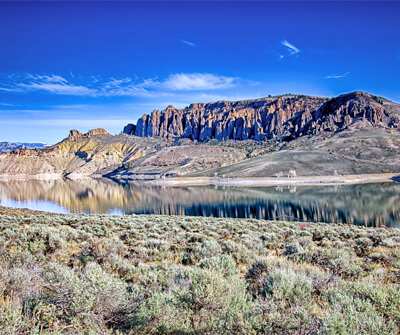
At Lake San Cristobal (W1), enjoy fishing, boating, and camping — or just stop for the view and a postcard-perfect photo, simply stunning.
Slumgullion Earthflow (A3) is a National Natural Landmark. The natural earthflow blocked the Lake Fork of the Gunnison River and formed Lake San Cristobal. Stop at the pull-out for views. The Windy Point Overlook offers more views of the slide area and the stunning 13,000 and 14,000-foot high peaks of the San Juan Mountains. Consider a side trip to Deer Lakes on Forest Road 788 where you’ll find fishing, numerous hiking trails, and campgrounds.
Like history on the creepy side? Don’t miss the Alferd Packer Cannibal Massacre Site (A2). Sometimes spelled Alfred, Packer is said to have eaten his traveling companions while traversing the high mountains during harsh winter conditions in 1874.
The road twists and turns as it heads to the historic town of Lake City, in the most remote county in the lower 48. Get outdoors hiking, biking, horseback riding, rock climbing, 4-wheel driving and winter activities such as skiing, snowshoeing and ice fishing. With stunning natural beauty, restaurants, shopping, entertainment, and special events year-round, Lake City makes a great base for exploring the region. Pick up an In-Town Walking Tour and admire historic buildings including the oldest operating courthouse in Colorado. At Hard Tack Mine Tours and Museum (M3), learn the history and process of mining inside an actual mine tunnel. The museum is home to vast rock and mineral collection. Open June to September, the tour is accessible for strollers and wheelchairs. The Hinsdale County Museum (M4), tells the story of the Denver and Rio Grande Railroad Lake City branch through video and photos. Artifacts, maps, books, and furniture offer a fascinating look back in time. Open Memorial Day to late-September. There is an entrance fee.
The byway officially ends at the junction of US-50. While here, spending time at the Curecanti National Recreation Area (H1) is a must. There are three reservoirs along the Gunnison River, Blue Mesa Reservoir, Morrow Point Reservoir, and Crystal Reservoir, havens for salmon and trout fishing, and boating, boat permit required. Don’t have your own boat? Take the Morrow Point Boat Tour which travels into the Black Canyon of the Gunnison National Park. To get to the boat requires taking the Pine Creek Trail and 2,362 stairs! Yes, you have to climb back up. Reserve tickets in advance from the Elk Creek Visitor Center or by phone 970-641-2337 ext 205. A number of trails for every level allow for wildlife watching, and exploration of diverse habitat. Try the easy 1.5-mile round trip, wheelchair accessible, Neversink Trail or explore the Dillon Pinnacles on a 4-mile moderately strenuous hike. A few trails are open for horseback riding (including lower section of Dillon Pinnacles Trail) and Dry Gulch and Ponderosa campgrounds have corrals. There are 8 other campgrounds for tents and RV’s. Curecanti is open year round, but note that East Portal Road is closed in winter, typically from mid-November to mid-April. There is no entrance fee unless you’re coming through the Black Canyon of the Gunnison National Park entrance which charges a fee or use your America the Beautiful Pass.

Share
 | ||||||
| Sun | Mon | Tue | Wed | Thu | Fri | Sat |
|---|---|---|---|---|---|---|
