

Trail of the Mountain Spirits
The Inner Loop Scenic Byway
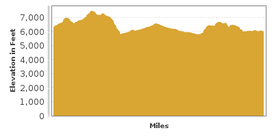
| Mileage | 73 miles (118 km) |
|---|---|
| DurationThe duration is an estimate of a one-way drive and does not include any stops or side-trips. | 1 hour, 47 minutes |
| SeasonsThe seasons listed are the best seasons for this scenic drive. If Winter is not mentioned, the road may be closed during the winter. | All Seasons |
| Roadways | New Mexico Highways 15, 152, and 35, and US Highway 180 |
| ServicesThe cities or towns listed have either Food or Services such as gas, pharmacies, etc. | Silver City, NM▼, and Pinos Altos, NM▼ |
| Rating | 3.6 average from 27 votes |
| My DrivesTrack your favorite scenic drives by selecting those which you want to take and those that you have taken. Using your free account, simply sign in and select My Drives. | |
| Share |

Our free Road Trip Planner will reverse the route and include the places of interests. Click the “Add to Road Trip” above to start planning your next road trip.
Send this link to your phone. Standard text messaging rates apply.
() -Get directions from your start address to the beginning of and including this scenic drive. Choose either an alternate ending or same as start.
Have more destinations? Use our free Road Trip Planner to completely plan your adventure. Click the “Add to Road Trip” above to start planning your next road trip.
This scenic drive travels through the first US National Forest, a historic mining town, cliff dwellings, and winding roads with endless mountain hills.
Our scenic drive is a counter-clockwise loop beginning in the town of Silver City. A major mining town, beginning with early Native Americans who found turquoise here, continues today with the nearby copper mine, one of the largest operations in the United States.
You can reach Silver City from US-180, which is easily reached off of I-10 or via NM-152 off of I-25. The town itself has an historic downtown with art galleries and studios, antique stores, restaurants and lodging. On the campus of Western New Mexico University is the Western New Mexico University Museum (M2), featuring one of the world’s most complete collections of Mimbres pottery, basketry as well as Navajo Rugs and other artifacts. This is also the childhood home of Billy the Kid.
Start the drive on Pinos Altos Road/NM-15 heading north, where in a few miles, you will arrive at the town of Pinos Altos. Spanish for “Tall Pines,” Pinos Altos also sits right beside the Continental Divide, where the western mountain streams flow towards the Pacific and streams to the east flow towards the Mississippi River towards the Atlantic Ocean.
Continuing north, you soon pass the Ben Lilly Monument (V1) commemorating the last active mountain man in the Southwest and big-game hunter extraordinaire. While not a naturalist, he provided a number of specimens to museums and even brought President Theodore Roosevelt hunting.
The next several miles are especially narrow and winding, so take extra care. In fact, wide vehicles are not recommended here. Heading through forest take in the grand views of the valley and sculpted rock formations. In 15-miles, the NM-35 splits at Sapillo Creek and wants to take you east, but resist that urge and continue north on NM-15 to the Gila Cliff Dwellings for a 17-mile side-trip.
Climbing up, you eventually arrive at the Anderson Scenic Overlook (V2) at the edge of a collapsed caldera. Expansive views of the Gila River Canyon 2,000 feet below and the photogenic Gila Wilderness, notably the first National Wilderness area in the United States, and the tallest peaks in New Mexico, the Mogollon Range. Continuing, you cross the shimmering Gila River and campgrounds with interesting rock formations.
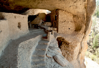
Arriving at the Gila Cliff Dwellings National Monument (H1), stop at the visitor center to orient yourself, pick up the guide, and explore exhibits featuring Mogollon artifacts and the lives of the Cliff Dwellers as well as a video on the Chiricahua Apache who consider this area home. These fascinating structures built by the Tularosa Mogollon people in the late 1200s consist of five natural caves that contain the ruins of the dwelling — a total of 40 interconnected rooms.
Guided tours start at the Cliff Dwellings and are offered daily at 1:00 p.m. It takes about one half hour to walk up from the trailhead. There are other trails as well — the shortest leaves from the Lower Scorpion Campground to a small dwelling and petroglyphs. Or head into the Gila Wilderness via the West Fork Trail and Middle Fork Trails. Little ascent in elevation but big in natural beauty featuring thick, beautiful forests, winding canyons, stunning cliffs, and several river crossings so have water shoes handy.
Other activities at the Monument include camping, fishing and wildlife viewing. Glimpse over 100 bird species including 7 species of hummingbird, vultures, and ravens, mammals such as mule deer or snakes, lizards. There are several hot springs in the area. Lightfeather is a 20-minute walk from the Gila Visitor Center. At 149 degrees F, it’s best to enjoy in a pool further down the river. If you’re up for a more adventurous day hike, try the 6 or 8 mile hike from the Visitor Center to Jordan Hot Springs depending on which trail you take.
Back on the NM-15, about a half of a mile south of the visitor center, explore the petroglyphs beside the road. Then backtrack back to the intersection and continue east on NM-35.
A few miles on NM-35 will lead to Lake Roberts (W1), a picturesque, general recreation lake, perfect for camping, picnicking, hiking, fishing, and wildlife watching. The road continues through these beautiful mountain and forested hills. In the town of Mimbres, stop at the Mimbres Ranger District (I1) for information about local hikes.
Continuing along, the NM-35 meets the Scenic New Mexico Highway 152. This drive continues west, passing the Santa Rita Copper Mine Overlook (V3), piñon pine and juniper trees, and back to Silver City. But consider heading east to continue on the Geronimo Trail Scenic Byway.

Share
 | ||||||
| Sun | Mon | Tue | Wed | Thu | Fri | Sat |
|---|---|---|---|---|---|---|
