
Strait of Juan de Fuca Highway to Neah Bay and Ozette
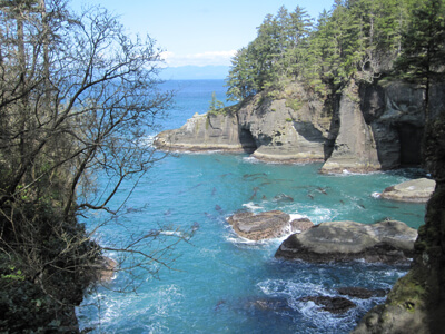
Along the rocky shore of the Strait of Juan de Fuca
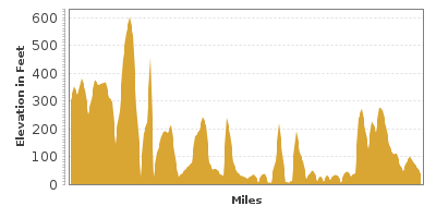
| Mileage | 102 miles (164 km) |
|---|---|
| DurationThe duration is an estimate of a one-way drive and does not include any stops or side-trips. | 3 hours |
| SeasonsThe seasons listed are the best seasons for this scenic drive. If Winter is not mentioned, the road may be closed during the winter. | All Seasons |
| Roadways | Washington Highway 112, and Hoko-Ozette Road |
| ServicesThe cities or towns listed have either Food or Services such as gas, pharmacies, etc. | Joyce, WA▼, Clallam Bay, WA▼, Sekiu, WA▼, Neah Bay, WA▼, and Port Angeles, WA▼ |
| Rating | 3.7 average from 56 votes |
| My DrivesTrack your favorite scenic drives by selecting those which you want to take and those that you have taken. Using your free account, simply sign in and select My Drives. | |
| Share |

Our free Road Trip Planner will reverse the route and include the places of interests. Click the “Add to Road Trip” above to start planning your next road trip.
Send this link to your phone. Standard text messaging rates apply.
() -Get directions from your start address to the beginning of and including this scenic drive. Choose either an alternate ending or same as start.
Have more destinations? Use our free Road Trip Planner to completely plan your adventure. Click the “Add to Road Trip” above to start planning your next road trip.
Hugging the coast of the Strait of Juan de Fuca along the northern tip of the Olympic Peninsula, this drive will bring you to the northwesternmost point of the contiguous U.S. where the Strait of Juan de Fuca meets the Pacific Ocean.
While the scenic byway officially starts where WA-112 crosses the Elwha River, the easiest way to get there is where WA-112 forks off the US-101. Using this route, you can get some information at the Wilderness Information Center in Port Angeles (I1). If you are closer to where the WA-113 intersects with the US-101, you could start there, although you will miss some beautiful rocky coast.
Driving west on WA-112 from Port Angeles, you will pass the Elwha River. Consider taking the Elwha River Road just after the river and stopping near the Elwha River Bridge (B1) for some great views of the river rushing into the Strait.
About five miles from the Elwha River, Salt Creek Recreation Area (H6) is on the right on Camp Hayden Road and features beaches, tide pools, and views of the Strait of Juan de Fuca, Crescent Bay, and Vancouver Island.
The highway continues west hugging the coast until near Pysht. In Pysht, Pillar Point State Park (H5) is small side-trip with beach access, perfect for picnics and romantic walks. To reach it, turn right (north) on Pysht River Road and follow it to the end.
About seven miles from Pysht, the WA-112 will meet WA-113, where you should keep to the right to stay on WA-112. The two-lane WA-112 is beautifully tree-lined with lots of twisties. Drive with care. On your way back home, consider heading back via the WA-113, which will bring you to the US-101 at Sappho, about 13 miles from Forks or 49 miles from Port Angeles.
Six miles further, you will be in Clallam Bay and the Clallam Bay waterfront (H1) is a beautiful beach to stop at. There is a nice footbridge in Clallam’s downtown that goes over Clallam River and brings you to the beach, where eagles, osprey, and other birds can usually be seen. From here, you can walk to the Slip Point Lighthouse and enjoy the low-tide marine life.
Just two miles up the road is Sekiu, Clallam Bay’s twin city. The Sekiu Trail (One-Mile Beach) (H3) is built on railroad grade and will bring you to the One-Mile Beach. For directions, stop at Olson’s Resort. If you like scuba diving or have always wanted to try, Sekiu has several places that rent equipment, lessons, and guided underwater tours.
About two miles from Sekiu, Hoko-Ozette Road is on your left. You can either head straight to Neah Bay or turn left to Ozette, which is where we’re heading first.
Head down Hoko-Ozette Road for 21-miles along the Hoko River, until you reach Lake Ozette and the Ozette Ranger Station (I2). Lake Ozette offers camping and boating, but one of the main reasons to drive all the way here are the coastal trails to the Pacific Ocean. Ozette Loop Trail (H11) is a roughly 9-mile hike to the Pacific Ocean, divided as a 3-mile hike to the Pacific Ocean at Cape Alava, 3-miles to Sand Point, and 3-miles back to the starting point. Alternatively you can hike to and back on either the Cape Alava or Sand Point Trails for a total of 6 miles. That won't include long walks on the lovely seaweed-strewn beach watching the waves roll in, marveling at uniquely-shaped sea stacks, and exploring tide pools. You may be fortunate to spot deer, birds, and marine life such as sea otters and whales. Look for Makah tribe petroglyphs at Wedding Rocks. The beach is popular for overnight backpacking/camping, permit and animal-resistant food containers required. Part of the Olympic National Park, there is an entrance fee or use your America the Beautiful Pass. There are no services along Hoko-Ozette Road, so be sure to pack everything you may need, and check your gas gauge. To head back to WA-112, just retrace your drive back on Hoko-Ozette Road.
Back on WA-112 West, rock formations Sail and Seal Rocks loom from the water, and if you're lucky, you may see harbor seals, puffins, or in the distance, gray whales. Take advantage of the overlooks and parking areas to observe more intently, and enjoy the beach and tide pools.
WA-112 ends in Neah Bay on the Makah Indian Reservation. The Makah Museum and Cultural Center (M2) preserves the history of the Makah tribe with exhibits featuring artifacts, traditional clothing, basketry, carvings, photos, as well as full-size replicas of canoes and a longhouse. There is an entrance fee. While enjoying the spectacular beaches and trails, all nonresident motor vehicles entering the Makah Nation require a Makah Recreation Pass which is valid for one calendar year. The pass is sold at the museum, the Makah Marina, and other establishments in town.
From here, take Cape Flattery Road for 8-miles to the Cape Flattery Trail (H4). A half-mile walk heads to the northwest-most part of the continental United States, where the Pacific Ocean feeds the Strait of Juan de Fuca. The smell of the ocean permeates the air, bull kelp dance in the waves, and the water glistens a brilliant blue green. Listen to sea lions barking from Snake Rock and the sound of waves crashing into, and carving the cliff sides. Gulls and eagles soar with the winds, while puffins and oyster catchers fish. Bring binoculars to observe birds and see the lighthouse on Tatoosh Island - and a jacket as the temperature can change quickly. Simply breathtaking, there is something magical about being at the edge of Washington state.
This coastal area all the way down to Copalis Beach is part of the Olympic Coast National Marine Sanctuary dedicated to providing a safe environment for a variety of birds, marine mammals, and plant life. A visitor and activity center, Olympic Coast Discovery Center (M1), is located in Port Angeles.
Hobuck Beach (W4) is easily accessed, no hiking required. Enjoy beach walks, birding, surfing, and swimming, or take a fishing charter. Make it an overnight with tent and RV camping, or an oceanfront cabin rental.
Sooes Beach (W3) is wonderful with all the natural beauty of the the Pacific Ocean - and no hiking to get there. Park across the street at one of the lots operated by locals.
If you're up for one more adventure, Shi Shi Beach Trailhead (H13) is not to be missed. The 7-mile roundtrip hike is moderate and rewards with outstanding views of the ocean and iconic Point of the Arches sea stacks. Look in the tide pools for crabs, anemones, clams, and sea snails. Walk and touch gently, and please do not take anything. The water is cold, but walking barefoot in the surf is wonderful. Only the very brave will jump in the waves or swim. Watch for rocky outcrops that can be hidden depending on the tide. The beach is also popular for camping. Permit and animal-resistant food containers required for overnight users.
On your way back from Neah Bay, consider heading back via Cape Loop Road and stopping at the Waatch Point (H10) for an overlook of Waatch River.
If you decided not to head to Ozette on your way up, consider it on your way back. After this, you can either head back via WA-113 which will bring you to Sappho, about 13 miles from Forks or 49 miles from Port Angeles or enjoy the Strait all the way home by using the WA-112 back to Port Angeles. Whichever you choose, you can continue on the Olympic Peninsula Loop from either location.

Share
 | ||||||
| Sun | Mon | Tue | Wed | Thu | Fri | Sat |
|---|---|---|---|---|---|---|
