
Death Valley Scenic Byway
The Great Desert
| Mileage | 130 miles (209 km) |
|---|---|
| DurationThe duration is an estimate of a one-way drive and does not include any stops or side-trips. | 3 hours, 37 minutes |
| SeasonsThe seasons listed are the best seasons for this scenic drive. If Winter is not mentioned, the road may be closed during the winter. | All Seasons |
| Roadways | California Highway 190 |
| ServicesThe cities or towns listed have either Food or Services such as gas, pharmacies, etc. | Furnace Creek, CA▼, and Death Valley, CA▼ |
| Rating | 4.0 average from 133 votes |
| My DrivesTrack your favorite scenic drives by selecting those which you want to take and those that you have taken. Using your free account, simply sign in and select My Drives. | |
| Share |

Our free Road Trip Planner will reverse the route and include the places of interests. Click the “Add to Road Trip” above to start planning your next road trip.
Send this link to your phone. Standard text messaging rates apply.
() -Get directions from your start address to the beginning of and including this scenic drive. Choose either an alternate ending or same as start.
Have more destinations? Use our free Road Trip Planner to completely plan your adventure. Click the “Add to Road Trip” above to start planning your next road trip.
Death Valley is the great desert, facing some of the highest temperatures and lowest elevation in this area of the world. These extremes bring extraordinary scenic beauty.
This scenic drive begins in Olancha at the intersection of US-395 and CA-190, and heads to Shoshone at the intersection of CA-190 and CA-127, of which following it to the south will bring you to I-15.
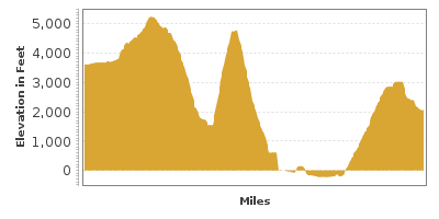
Heading west on CA-190 from Olancha, the drive heads through the Owens Lake Bed and then starts climbing up the Argus Range until you enter the Death Valley National Park. The drive continues into the park’s Panamint Valley, where you will see the Panamint Dunes in the distance.
After the climb up, keep an eye out for Wildrose Road heading to Aguereberry Point (V1). At 6,433 feet of elevation, Aguereberry Point provides an incredible view of Death Valley. After 11 miles on Wildrose Road, turn onto the dirt Aguereberry Road for the final 6 miles.
Continuing east on CA-190 for 9 miles, a 2.3-mile side-trip will bring you to Mosaic Canyon (H1), a short and easy walk in Death Valley through a narrow, multicolored, layered marble that was carved by water.
Where CA-190 heads south in 7 miles, consider a side-trip on Scottys Castle Road, which will bring you to both Scottys Castle (M1) and Ubehebe Crater (H2). Scottys Castle is a Spanish Villa built by Albert Johnson in the early 1900s at a cost exceeding $1.4 million. Today the castle is open for tours.
The Ubehebe Crater (H2) is a field of steam explosions that carved craters known as maars. The Ubehebe Crater was the largest and last formed in the area.
Back on CA-190, 4-miles from the Scottys Castle Road turn-off, the Salt Creek Interpretative Trail brings you to one of the few places in Death Valley that has a spring. Although the water retreats in the height of summer, the stream is home to the endangered pupfish. Up ahead, the Furnace Creek area has natural springs which gush more than 600 gallons of water a minute, creating a very green and lush environment. The Furnace Creek Visitor Center and Museum (M2) is a great place to get information or to learn about the area.
After Furnace Creek, consider a side-trip on Badwater Road (T1) bringing you to a lake saltier than an Ocean and is 179 feet below sea level. On the way there, you will pass Golden Canyon which is worth a stop. Artists Drive (T2) is a 9-mile loop also off of Badwater Road which leads to a colorful blend of minerals, sediments, and volcanic materials.
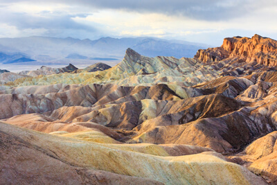
Back on CA-190, Zabriskie Point (T3) will be on the right in 4-miles from Badwater Road, where you can view the ancient lakebeds. From here, you can continue on a gravel road down to the badlands and the Twenty Mule Team Canyon.
Heading west on CA-190, you will soon arrive at Dante’s View (T4). A 13-mile windy and steep stretch of road will reward you with a spectacular view of Death Valley. With the Badwater Lake below and the Panamint mountains ahead, this is a must see.
The scenic drive completes as the CA-190 ends. From here, you can head south on CA-127 to I-15. Or consider a trip to the ghost town of Rhyolite, Nevada. Explore the dilapidated ruins and remnants of saloons, hotels, homes, a bank, train station and more in what was a thriving mining town in 1904. Don't miss the eerie and whimsical sculptures nearby at the Goldwell Open Air Museum. The museum is free and open 24/7.

Share
 | ||||||
| Sun | Mon | Tue | Wed | Thu | Fri | Sat |
|---|---|---|---|---|---|---|
