

Grand Mesa Scenic Byway
The world’s largest mesa
| Mileage | 50 miles (80 km) |
|---|---|
| DurationThe duration is an estimate of a one-way drive and does not include any stops or side-trips. | 1 hour, 1 minute |
| SeasonsThe seasons listed are the best seasons for this scenic drive. If Winter is not mentioned, the road may be closed during the winter. | All Seasons |
| Roadways | Colorado Highway 65 |
| ServicesThe cities or towns listed have either Food or Services such as gas, pharmacies, etc. | Mesa, CO▼, Palisade, CO▼, and Cedaredge, CO▼ |
| Rating | 3.9 average from 70 votes |
| My DrivesTrack your favorite scenic drives by selecting those which you want to take and those that you have taken. Using your free account, simply sign in and select My Drives. | |
| Share |

Our free Road Trip Planner will reverse the route and include the places of interests. Click the “Add to Road Trip” above to start planning your next road trip.
Send this link to your phone. Standard text messaging rates apply.
() -Get directions from your start address to the beginning of and including this scenic drive. Choose either an alternate ending or same as start.
Have more destinations? Use our free Road Trip Planner to completely plan your adventure. Click the “Add to Road Trip” above to start planning your next road trip.
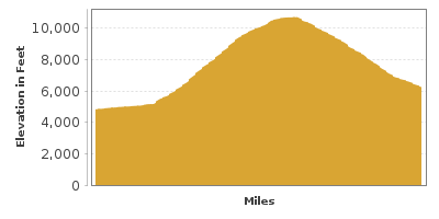
Grand Mesa is the largest, flat-topped mountain in the world, spanning 500 square miles and rising between 5,000 feet and 11,237 feet of elevation. The top of the Grand Mesa is a layer of basalt poured by lava approximately 10 million years ago which has protected the mesa from the erosion suffered by surrounding sedimentary rocks.
The scenic drive begins at exit 49 off I-70 on CO-65 and travels east to Cedaredge. There is a 13-mile side-trip to the Land’s End Observatory which adds 40 minutes to the drive.
Following Plateau Creek, the CO-65 climbs the canyon’s bluff and the Grand Mesa, passing farms and ranches on the way. While Grand Mesa dominates the view, to the east, you can also see the 6,282-foot Beehive Butte looming tall from Utah.
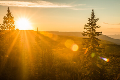
Continuing on CO-65, you enter the Grand Mesa National Forest and are greeted by one of the many scenic overlooks, this one with fabulous views of the Debeque Canyon, aspen-covered slopes, and some of Grand Mesa’s 300 lakes. The region supports a variety of recreation opportunities for any season. Wildflowers awaken with colorful blooms in spring and summer, calling to explore with leisurely strolls, picnics, hiking, biking and fishing. During fall, the aspen leaves change and the forest gleams like a golden treasure. Powderhorn Mountain Resort (A2) is open year-round. In spring, summer and fall, take the quad-lift up and test your downhill mountain biking skills, hiking, or just admire the stellar views. In winter, ski and snowboard across 1600-acres with trails for every level of ability. There are equipment rentals, lessons available on-site, as well as slope-side lodging, restaurants, and shops.
After a couple of bends, you arrive at the Mesa Lakes Recreation Area (H1). Seven lakes within walking distance of each other offer access to non-motorized boats and fishing. Camping and extensive hiking and biking trails can be found here. Larger lakes and reservoirs allow motorized boats but horsepower allowed varies. Please check the Colorado Boatable Waterways Directory for specific information. Along the Grand Mesa, you'll find many lodges, dining options, convenience stores, equipment rentals, and information services.
Just up the road, turn right onto Forest Road 100, for a 10-mile gravel road side-trip which leads to Land’s End Observatory (T1). Sitting on the edge of Grand Mesa, the beautifully-handcrafted ranger Observatory was built by the Works Progress Administration and Civilian Conservation Corps from 1936-37. Breathe deeply as you take in sweeping views of Grand Valley, Book Cliffs, the red cliffs of Colorado National Monument, and into Utah, which is over 80-miles away. The Forest Service has a visitor center here that is open during the summer. Along the road, you will notice the environment change from lush grass into drier sagebrush. Stop at the Raber Cow Camp, where in the 1940s, ranchers lived during summer while cattle grazed. Land’s End Road then heads down to Grand Mesa and to the US-50, but for this scenic drive, we retrace back to CO-65.
Back on CO-65, you soon arrive at the Land-O-Lakes area, boasting 18 lakes all with walking distance of each other. A short trail leads to the Lands-O-Lakes Overlook (V2) which captures magnificent views. The nearby Crag Crest National Recreation Trail (H2), is a 10.3-mile loop trail that heads to the rocky Crag Crest through a beautiful forest and open meadows. It is recommended that you start this hike early to avoid afternoon thunderstorms.
Continuing along the road, you arrive at the Grand Mesa Visitor Center (I1) where you can learn more about the Grand Mesa through exhibits, a unique High-Altitude Native Garden and interpretive hiking trail. Surrounding the visitor center are several lakes and campgrounds where you can enjoy hiking, boating, and fishing.
From here, the road descends towards Cedaredge passing apple orchards and fruit stands. In Cedaredge, the Byway Welcome Center (I2) provides more information about the scenic byway you have just driven, but the most interesting stop here is Pioneer Town (A1), which explores the frontier life of early settlers with preserved and restored buildings such as a country store, old-time saloon, jail, bank and working blacksmith shop.
Our scenic drive officially comes to an end here, but you can continue south on CO-65 towards Delta, enjoying the Adobe Buttes, the Delta County Historical Society Museum (M1), and outstanding scenery on your way to US-50. Heading west on US-50 will bring you to Grand Junction where you can explore the Unaweep-Tabeguache Scenic Byway and the Colorado National Monument, or head east on US-50 towards Montrose and the snowy peaks of the San Juan Skyway.

Share
 | ||||||
| Sun | Mon | Tue | Wed | Thu | Fri | Sat |
|---|---|---|---|---|---|---|
