

River Road Scenic Byway
The Mighty AuSable River
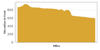
| Mileage | 30 miles (48 km) |
|---|---|
| DurationThe duration is an estimate of a one-way drive and does not include any stops or side-trips. | 40 minutes |
| SeasonsThe seasons listed are the best seasons for this scenic drive. If Winter is not mentioned, the road may be closed during the winter. | All Seasons |
| Roadways | Michigan Highway 66, and River Road |
| ServicesThe cities or towns listed have either Food or Services such as gas, pharmacies, etc. | Oscoda, MI▼ |
| Rating | 3.6 average from 26 votes |
| My DrivesTrack your favorite scenic drives by selecting those which you want to take and those that you have taken. Using your free account, simply sign in and select My Drives. | |
| Share |

Our free Road Trip Planner will reverse the route and include the places of interests. Click the “Add to Road Trip” above to start planning your next road trip.
Send this link to your phone. Standard text messaging rates apply.
() -Get directions from your start address to the beginning of and including this scenic drive. Choose either an alternate ending or same as start.
Have more destinations? Use our free Road Trip Planner to completely plan your adventure. Click the “Add to Road Trip” above to start planning your next road trip.
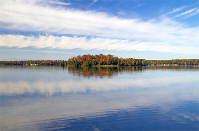
The Great River Road travels from Hale to Oscoda along the AuSable River. The river was long used by Native Americans for travel and trade and later for transporting timber to Lake Huron. Tranquility and natural beauty await along this short drive, with many opportunities for hiking, fishing, camping as well as learning the history of the AuSable and enjoying the views.
This scenic drive begins in Hale on M-65 heading east. Loud Dam Pond and Five Channels Dam Pond (W1) are two of many access points to the AuSable for boating and fishing for trout, salmon, walleye, crappie, large and smallmouth bass and perch. There are outfitters along the entire length of the river offering equipment rentals. Meandering down the river on a kayak or canoe delivers breathtaking views and the peaceful sound of birds and flitting of dragon flies.
The road travels along high bluffs, making many of the attractions a long way down. At Iargo Springs (A1), descend 294 stairs and immerse yourself in a lush, verdant wonderland. Clear water fills pools and streams, tumbles over small waterfalls and spouts from underground springs. Stroll along the boardwalks which wind through the forest. Every season reveals beautiful flora and autumn colors are particularly dazzling. If you don’t walk down, there is an overlook from the parking lot, as well as interpretive panels depicting the importance of the springs to the Native Americans who lived here.
Beginning at Iargo Springs is the 7-mile Highbanks Trail (H5), where you can hike along the bluffs to the end of Cooke Dam Pond at Sid Town Village. You can also access the trail from Canoer’s Memorial and Lumbermans’ Monument. The trail is open in winter for cross-country skiing and snowshoeing though it is not maintained. The Canoer’s Memorial honors four canoer’s who lost their lives in a canoe race. Held at the end of July, the ultra-competitive AuSable River Canoe Marathon travels 120 miles non-stop from Grayling to Oscoda and draws the best professional paddlers since it began in 1947.
Spot resident eagles at the Eagle’s Nest Overlook. This area is a birders paradise and there are many opportunities to observe them.
Next stop is the 14-foot Lumberman’s Monument (A2). Erected in 1931, three bronze figures depict different stages of the lumber industry. The Lumberman’s Monument Visitor Center explores the logging history of the region and kids of all ages will love the hands-on activities that let them experience the life of a lumberjack. Then take 272 steps down to Cooke Dam to see a Wanigan, a floating kitchen and supply raft used by loggers, as well as to take in beautiful views of the river and dunes. You can also participate in ranger-led walks and activity programs and get information about the region and hiking trails, etc. The site is free, donations accepted.
Located in the heart of the Huron National Forest is the Corsair Trail System (H1). A collection of 15 loops offer 44-miles of trails for every level. Open year-round, this is a top destination in winter for its well-groomed cross-country and snowshoeing trails which are maintained by a group of dedicated volunteers. You can access trailheads off Monument Road or from Tawas.
Cooke Pond (H2) features an accessible public fishing pier and motor boat access above the dam. Canoe and kayakers have access below the dam.
Foote Site Park (H3) is the only public swimming beach along the route and here you’ll also find a boat ramp and camping. Cruise the river aboard the AuSable River Queen (A3), a double-deck paddlewheel boat. There are a variety of tours, some featuring live music. Fall color tours are extremely popular and reservations are a must.
The road continues to Oscoda where the AuSable meets Lake Huron. Though the official byway ends here, there is still much more to experience.
In Oscoda, enjoy a bounty of sandy beaches that offer all types of water recreation and relaxation. Stroll the quaint downtown and enjoy delightful shops, dining and the seasonal farmers market at AuSable Shoreline Park on Wednesdays.
Oscoda has been designated the official home of Paul Bunyan, the fictional story lumberjack. Join in the Paul Buynan Days, a festival held in September featuring carnival rides, chainsaw carving, log chopping as well as live music, fair food, game booths and more. Or take a photo of the quirky roadside sculpture of 13-foot tall Paul Bunyan Sculpture (A4) and his sidekick Babe, a blue ox.
Savor the region along the Sunrise Side Wine and Hops Trail (H6). Enjoy wine and beer tasting, and learn about grapes, hops and production through tours of the wineries and breweries.
Tawas is a lovely town and makes a great base for exploring the area. Tawas State Park (H7) is a premier destination for kite-boarding and wind-surfing. Of special note for birders, it is also touted as the best migrant bird trap in the watershed especially in spring and fall. Take the Sandy Hook Nature Trail to the end of the peninsula for birds, wildlife and stellar views. Or climb 85 steps to the top of Tawas Point Lighthouse. There is an entrance fee for all Michigan State Parks.
The Tuttle Marsh National Wildlife Area (H4) is another draw for birders and wildlife aficionados. Coastal wetlands and mud flats attract a variety of ducks and water-fowl, egrets, warblers and raptors. Marsh and forest areas are home to black bear, bobcat, white-tail deer, beaver, and otter. Informative interpretive panels educate about the plants and animals that make their home here. This natural 5000-acre wetland does not have any facilities.
Observe more resident and migrating birds with a drive along the Saginaw Birding Trail which circumnavigates Saginaw Bay. The 142-mile trail travels from Tawas to Port Austin. Maps with points of interest and hot spots are available online.

Share
 | ||||||
| Sun | Mon | Tue | Wed | Thu | Fri | Sat |
|---|---|---|---|---|---|---|
