
Red River Gorge Scenic Byway
Over one hundred natural stone arches
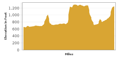
| Mileage | 45 miles (72 km) |
|---|---|
| DurationThe duration is an estimate of a one-way drive and does not include any stops or side-trips. | 1 hour, 13 minutes |
| SeasonsThe seasons listed are the best seasons for this scenic drive. If Winter is not mentioned, the road may be closed during the winter. | Spring, Summer, and Fall |
| Roadways | Kentucky Highways 11, 15, 715, and 77 |
| ServicesThe cities or towns listed have either Food or Services such as gas, pharmacies, etc. | Slade, KY▼, Crystal, KY▼, and Beattyville, KY▼ |
| Rating | 3.3 average from 197 votes |
| My DrivesTrack your favorite scenic drives by selecting those which you want to take and those that you have taken. Using your free account, simply sign in and select My Drives. | |
| Share |

Our free Road Trip Planner will reverse the route and include the places of interests. Click the “Add to Road Trip” above to start planning your next road trip.
Send this link to your phone. Standard text messaging rates apply.
() -Get directions from your start address to the beginning of and including this scenic drive. Choose either an alternate ending or same as start.
Have more destinations? Use our free Road Trip Planner to completely plan your adventure. Click the “Add to Road Trip” above to start planning your next road trip.
This drive travels from Stanton to Zachariah, Kentucky through the Red River Gorge National Geological Area nestled the Daniel Boone National Forest. Named for Daniel Boone, American pioneer and explorer who founded one of the first settlements west of the Appalachians, the forest delights with an incredible landscape featuring over one hundred natural stone arches, second only to Utah for the state with the most arches. Add in soaring sandstone bluffs, rock shelters, waterfalls, and lush green foliage, it’s no wonder why the Red River Gorge is a designated National Natural Landmark.
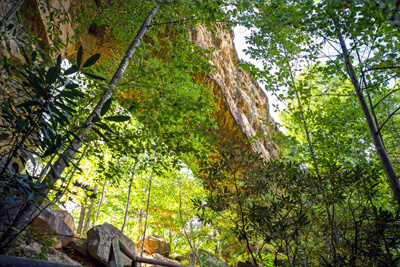
This short drive explores what took 70 million years of erosion by wind and water to sculpt. You’ll find a myriad of trails for every level — many of them less than one mile to the arches and unique rock formations. Though some hikes are easy, please use caution as there are exposed high cliffs and other rock hazards.
Our drive begins in Stanton, heading west on KY-11. A magical journey lies ahead as you pass through Nada Tunnel (B1). Gateway to the Red River Gorge, the 900-foot long tunnel was originally built between 1910-1912 to facilitate the transportation of logs via narrow gauge rail.
After the tunnel, turn left to access the Auxier Ridge Parking Area (H1). All trails in the Daniel Boone National Forest are numbered, and in this area trails #201-204 can be hiked individually or combined to explore Courthouse Rock, Haystack Rock and Double Arch. The top of Auxier Ridge affords extraordinary views of the Cumberland Mountains and Chimney Rock and Ravens Rock in the distance.
After crossing the steel bridge, the byway follows the twists and turns of Red River, the first National Wild and Scenic River in Kentucky.
At the Chimney Top Recreation Area (H3) is a paved trail to the Chimney Top Overlook. Take trail #235 for a closer look at the 900-foot Chimney Top Rock, and trail #233 to Princess Arch. The 307-mile Sheltowee Trace National Recreation Trail (H6) cuts through the Red River Gorge Geological Area. Between the parking area and Princess Arch is access to a wonderful section of the trail with a suspension bridge that crosses Red River.
Whether you hike for hours or just take a short stroll, you’ll enjoy a vibrant forest of ferns, rhododendrons, beech, sugar maple, hemlock, and hickory trees. Birders can observe over 100 species including the endangered red-cockaded woodpecker. Spring brings a colorful array of wildflowers such as white bloodroot, pink lady’s slipper, and Virginia bluebells. The rich colors of fall foliage are a draw for leaf-peepers. The park is open year-round, but in winter roads may be closed due to weather. Always check before heading out.
Learn about the cultural heritage and the surrounding geology through interpretive exhibits at the Gladie Cultural Environmental Learning Center (A2). You’ll also find information on hiking, camping, and free ranger-led activities. The nearby Gladie Historic Site features a reconstructed log cabin, originally built in the 1880’s, replete with period furnishings, farm equipment and more.
The road continues on KY-715, skirting the Clifty Wilderness. Consider at stop at Tower Rock trail #229, to explore or climb the massive rocky outcrop. The Red River Gorge is renowned for rock climbing and rappelling. If you’re an expert or want to learn, there are outfitters along the route offering rock climbing expeditions for all levels.
Turn right on KY-15 after crossing the intersection of the Bert T Combs Mountain Parkway (US-402).
The Sky Bridge Recreation Area (H5) features picnic tables, accessible services, and trails. Hike the easy 1-mile loop trail #214 which traverses above and below the stunning Sky Bridge — a 75-foot long natural arch bridge.
There are many interesting rock formations to see. Up next is Whistling Arch, trail #234 and a short walk from the parking area is trail #218 to Angel Windows.
At Rock Bridge Road, consider a detour from the byway to Rock Bridge Recreation Area (H4) to explore Rock Bridge Arch, trail #207, the only arch that spans water. Nearby is the graceful Creation Falls.
The byway continues on KY-15. Stop at Koomer Ridge (H8) to discover Silvermine Arch trail #225, Hidden Arch trail #208 or Cliff Trail #206. There is semi-primitive camping for tents and RVs.
At Exit 33, the junction of KY-15 and KY-11 you can head back to Stanton or Slade — or continue the official byway via KY-11 South to Zachariah.
In the small town of Slade, you’ll find dining options, accommodations, and outfitters offering canoe and kayak tours or rock climbing expeditions. Or visit the Kentucky Reptile Zoo (A1) which boasts one of the largest collections of venomous snakes in the world. Don’t miss the fascinating live venom extraction program each day. The venom is used for science and pharmaceutical research to make antiserum. Open from Memorial Day through Labor Day. There is an entrance fee.
The byway continues to Natural Bridge State Resort Park (H2). The 78-foot long and 65-foot high Natural Bridge is the focal point and is believed to be at least one million years old. There are a few trails to view Natural Bridge, from the easy 3/4-mile Original Trail with an elevation gain of 400 feet, to the Balanced Rock Trail (part of the Sheltowee Trace Trail) which is also 3/4-mile, but is very steep with over 600 stairs! Or take the easy way up. The Sky Lift is a chairlift that rewards with exceptional views and leaves you within an easy walk to the top of Natural Bridge. There is fee charged. Along with many other rock features and trails, this park has an impressive array of amenities that makes it a great overnight base. Stay in Hemlock Lodge, a cottage rental, or camp at Whittleton Campground or Middle Fork Campground. Enjoy fishing for bass, sunfish, rainbow trout and channel catfish in Mill Creek Lake, or take advantage of on-site canoe and kayak rentals and a swimming pool which is included if you stay at the Lodge or cottages. A small fee charged if you just want to swim for the day. There is no fee to enter Kentucky State Parks.
The byway officially ends in ends in Zacharia. From here consider a visit to Beattyville. Paddle along the Kentucky River, then stroll Main Street shopping for antiques and savor delicious down home cuisine. The third full weekend in October is the Woolly Worm Festival. The wooly worm is used to forecast the winter season. Each of the 13 segments of the worm corresponds to a week in winter. If the segment is light brown, the week will be mild, if it’s black, the week will be cold. We can’t state our reputations on the accuracy but we love any excuse for a celebration. The festival features live music, craft booths, parades, a car show, and fair food.
We would be remiss if we didn’t recommend a visit to Cumberland Falls State Resort Park (H7). Known as the Niagara of the South, Cumberland Falls is 125 feet wide and tumbles 68 feet down. During a full moon, it is the site of a rare phenomenon, a moonbow, created as the bright moonlight refracts through the mist. Check the park website for full moon dates. Don’t miss the 1.5-mile trail that leads to another dramatic cascade, Eagle Falls. The park offers the gamut of recreation opportunities, from 17-miles of hiking, biking, trails, guided horseback riding tours, swimming in an Olympic-sized pool, guided rafting trips, bird watching, and gem mining. With so much to do, stay overnight in a cottage or cabin rental, in the beautiful DuPont Lodge, or camping.

Share
 | ||||||
| Sun | Mon | Tue | Wed | Thu | Fri | Sat |
|---|---|---|---|---|---|---|
