

Connecticut River Byway
The Great North Woods

Our free Road Trip Planner will reverse the route and include the places of interests. Click the “Add to Road Trip” above to start planning your next road trip.
Send this link to your phone. Standard text messaging rates apply.
() -Get directions from your start address to the beginning of and including this scenic drive. Choose either an alternate ending or same as start.
Have more destinations? Use our free Road Trip Planner to completely plan your adventure. Click the “Add to Road Trip” above to start planning your next road trip.
The Connecticut River Byway parallels the Connecticut River traveling through New Hampshire, Vermont, and Massachusetts. Explore a route less traveled amidst lush wilderness, tree-laden mountains, serene lakes and meandering streams that beckon you to the great outdoors. Add in covered bridges, waterfalls, a myriad of state parks, friendly towns and villages for an adventure that’s a feast for your eyes and spirit.
In this drive, we describe just the route that travels through New Hampshire, beginning in Pittsburgh near the border of Quebec, Canada, to Winchester, at the border of Massachusetts. Of course, you can drive in either direction. The Connecticut River divides New Hampshire and Vermont — where lie other incredible natural, historic, and cultural sites.
We begin the byway near the border of Quebec on US-3 heading south. The road from here to Pittsburgh is known as Moose Alley, boasting more moose than population, so be alert while driving, especially in the evening. Moose watching is a popular tourist activity. The best chance to spot them is at dawn and dusk as they feed in wetland areas — including those on the side of the road. Do not approach moose. They may seem docile, but they are very protective of their calves and can be unpredictable. Neighboring Canaan, Vermont hosts an annual Moose Festival at the end of August, typically the last weekend before Labor Day. Among the many activities, are a moose calling contest, moose chili, classic car show, artisans, and an old fashioned barn dance.
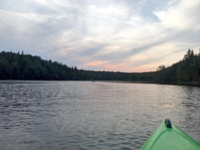
The lakes of the Great North Woods are a draw for fly-fishing brook trout, rainbow trout, brown trout, cusk, and landlocked salmon. In winter, bundle up as the lakes are open for ice fishing. Fed by the Connecticut River, the lakes are named from north to south, Third Connecticut Lake (W3), Second Connecticut Lake (W2), and First Connecticut Lake (W1). Marvel at being serenaded by the soulful call of loons who have made these lakes home. The Common Loon, as opposed to their name, is a threatened species in New Hampshire. Please keep a distance of 400-feet or more from loons and nesting sites. Great blue herons, bald eagles, deer and fox can also be observed.
Deer Mountain Campground (A1) offers 25 primitive sites open Memorial Day to Columbus Day. From the campground is access to the Cohos Trail, a 170-mile wilderness hiking trail from the Canadian border in Pittsburgh to Crawford Notch in the White Mountains. There are day hike sections as well.
Covered bridges are quintessential New England, full of romance and reminiscent of a time long past. But they are also technological marvels, expertly designed and constructed. There are 9 bridges along or not far from this route. Listed from north to south: the Happy Corner Covered Bridge (B1) built in the mid-1800’s; the Pittsburgh-Clarksville Covered Bridge (B2) which is closed to traffic; the River Road Covered Bridge (B10); the Columbia Covered Bridge (B3) which crosses to Lemington, Vermont; the 134-foot Stark Covered Bridge (B5) which was built in 1862; the Groveton Covered Bridge (B4) paddleford truss with added arches constructed in 1852; the Mechanic Street Covered Bridge (B6) built in 1862; the howe truss Mount Orne Covered Bridge (B7) built in 1911; and the Cornish-Windsor Covered Bridge (B9), the longest wooden covered bridge in the U.S and the longest two-span covered bridge in the world. It was built in 1866 and you can drive across to Vermont. All NH covered bridges are listed on the National Register of Historic Places.
At Lake Francis State Park (H3) have fun swimming, fishing, canoeing, kayaking, or hit the ATV trails. Stay overnight tent and RV camping under particularly dazzling starry skies.
If time allows, and you don’t mind a 12-mile drive on a dirt logging road, consider a detour to the 40-foot high Garfield Falls (H5). The falls, as well as surrounding hiking trails and refreshing swimming holes make this a superb day trip.
A bounty of resorts, lodges, lakeside cabins, small inns, and hotels dot the region. In Pittsburgh, you’ll find outfitters with fishing gear, ATV and snowmobile rentals, as well as guided tours to help you create an exhilarating outdoor adventure. With the reputation of being the “Snowmobiling Capital of New England”, Pittsburgh boasts 200-miles of groomed snowmobile trails that also connect with trails in Maine, Vermont and Quebec. And there are hundreds of miles of ATV trails, which also connect to the 1,000-mile Ride the Wilds system that winds its way through Coos County.
Take a step back in time at the Poore Family Homestead Historic Homestead Museum (M1). Learn about life in the 1830’s to the 1980’s of while exploring the home, barns and outbuildings of an original farm settlement. Peruse a collection of artifacts photos, furniture, horse drawn wagons, farm tools and clothing. Special events include living history reenactments, music festivals, and weaving, tanning, and axe-making demonstrations. Open June — September. There is a suggested donation for entrance. Kids under 12 get in free.
Coleman State Park (H2) in Stewartstown is chock full of amenities. Enjoy boating and premier trout fishing on Little Diamond Pond, tent, RV and ATV camping sites, as well as year-round cabin rentals. Hit the trails mountain biking, walking, or access the Cohos Trail. In winter, enjoy cross-country skiing, snowshoeing, and snowmobiling. Boat and snowshoe rentals available on-site.
Magalloway Mountain (H4) is a popular hiking destination culminating with exceptional views. The mile long (one way) trail heads up to 3,383-feet, rising an elevation about 700-feet. Make it a loop by taking the Coot Trail up and the Bobcat Trail down. Both trailheads are close to each other. At the summit, there is a Fire Lookout Tower. Experience the life of a watchman by renting the Watchman’s Cabin for an overnight stay.
In Colebrook, stop at Beaver Brook Falls Wayside (H1). The 7.3-acre park offers easy viewing of the 80-ft Beaver Brook Falls from the road or parking area, or hike for different vantage points. Snack at a waterside picnic table or picnic shelter. In town, discover shopping, antiquing, restaurants, outdoor suppliers, and more. If you’re spending time in Colebrook, don’t miss the River Walk which begins at the municipal parking lot.
More waterfalls and other natural areas lie to the east. Cruise to Dixville Notch State Park (H6). The focal point is a scenic gorge and two captivating waterfalls, the Dixville Flume and Huntington Cascades. Hiking trails create a loop around the gorge. Or hike the 1.5-mile round trip, 700-foot elevation gain to the summit of Table Rock on the Table Rock Trail. There is a less steep, but longer trail beginning at the access road near The Balsams.
While this far east, head to Errol close to the border of Maine and explore the Lake Umbagog National Wildlife Refuge (W6). Sitting at the southern range of the boreal forests and the northern range of the deciduous forests, this area is a transition zone and home to species of both habitat types. A birdwatchers paradise, observe 137 species of birds that breed here, and 229 bird species that stop off on their annual migration. The handicapped-accessible Magalloway River Trail and Observation Platform is perfect for wildlife watching and introspect. With Lake Umbagog and the Magalloway River making up much of the refuge, explore by boat, kayak or canoe. Camping at Lake Umbagog is by advance reservation only. In the town of Errol you’ll find gear and boat rentals, outfitters offering Class II and III whitewater rafting tours on the Androscoggin River, Lake Umbagog pontoon tours, and guided fishing expeditions and more. Nearby Mollidgewock State Park (H19) within the Thirteen Mile Woods Scenic Area, offers canoeing and kayaking on the Androscoggin River, access to rapids, wildlife watching, and camping.
The Connecticut River Byway continues on US-3. Lancaster is considered the gateway to the Great North Woods Region (if you’re coming from the south). You’ll find an abundance of lodging, restaurants, shops, and services. Built in 1780, the Lancaster Historical Society Wilder House Museum (M2) was the first two-story house, and now the oldest standing house in Coos County. Visit and browse artifacts and photographs. It is also now home to the Lancaster Historical Society.
Weeks State Park (H8) is named for Senator John Wingate Weeks who sponsored the legislation creating the extraordinary White Mountain National Forest in 1910. Learn more about him and his legacy at the summit house museum. Drive up the 1.6-mile Mountain Road Scenic Byway to the summit of Mount Prospect, keeping an eye out for walkers and cyclists that share the road. Enjoy a picnic, then climb 48 steps of the stone observation tower built in 1912 to outstanding panoramic vistas, or go hiking and geocaching. Participate in a wide range of nature and educational programs such as guided migratory bird or spring wildflowers walks, learn about the Underground Railroad in NH, covered bridges, and more. In winter, enjoy downhill skiing (rope tow), cross-country skiing, snowmobiling, and snowshoeing. There is a day-use fee for all NH State Parks.
Mount Cabot (H7) is one of NH’s 4,000-footers and popular hiking destination. Fall is glorious in New Hampshire. Generally, the peak season is the last week of September to the first week of October. Whether you hike up any of New Hampshire’s peaks, or picnic at the base, you’ll be rewarded with a splendorous palette of color.
At Forest Lake State Park (H10) relax along the 200-foot sandy beach, and enjoy swimming, fishing, kayaking or canoeing. There is no boat launch, so prepare to carry watercraft a few hundred feet from the parking area.
At the junction of NH-142, you can detour from the Connecticut River Byway and explore the White Mountains on the White Mountain Trail.
Our scenic drive continues south on NH-135 towards the charming, vibrant town of Bethlehem. Bethlehem makes a great base for exploring the region, delighting with an array of lodging, shop-filled historic buildings, cafes, restaurants, art galleries and antiquing.
The 38-acre Bedell Bridge State Park (H12) is named for the second longest, two-span covered bridge in the country. Sadly, it was destroyed by wind in 1979. Relax amid views of the Connecticut River, or go fishing and boating.
To truly appreciate the beauty of this area, you need to get out of the car and explore. The Chesterfield Gorge Natural Area (H14) is a beautiful wooded landscape, with alluring cascades and waterfalls. Enjoy easy walking trails, or scramble over rocky slabs.
Spofford Lake (W5) is an exciting lake vacation destination, popular for swimming, power boating, jet skiing, kayaking and canoeing. All are welcome to spend the day at Wares Grove Beach (also known as South Shore Beach) which features shallow water for a distance, making it perfect for young children, as well as a concession stand, volleyball, basketball, tetherball, and play structure. There is an admission fee. Note that North Shore Beach is for town residents only.
Don’t miss the Wantastiquet Mountain Natural Area (H15). Hike the summit trail to panoramic views overlooking Brattleboro, Vermont and the Connecticut River. If you continue your hike to the eastern side, discover a hidden gem — the stone staircase known as Madame Sherri’s Castle Ruins. Madame Sherri was a costume designer for the Zigfield Follies in the 1920’s who built an elaborate home in the woods to host parties. The remnants are fascinating. You can also drive to a closer trailhead in Madame Sherri Forest via Gulf Road. Mount Wantastiquet is just a half-mile walk from downtown Brattleboro, Vermont.
At 13,000-acres, Pisgah State Park is the largest of New Hampshire’s state park system. Explore via a network of hiking, biking, and horse-back trails for every level of ability. Walk the pleasant 5.5-mile Kilburn Loop which travels around Wilburn Pond, Canoe or kayak on the Pisgah Reservoir. The expansive park is also a playground for ATV and off-road vehicles. In winter, enjoy a snow-draped wonderland by cross-country skiing, snowshoeing and snowmobiling.
The drive ends at the border of Massachusetts. After all the action, kick back and relax at the Northfield Drive-In Theatre (A4).

Share
 | ||||||
| Sun | Mon | Tue | Wed | Thu | Fri | Sat |
|---|---|---|---|---|---|---|
