Cherohala Skyway
From Cherokee National Forest to Nantahala National Forest
| Mileage | 52 miles (85 km) |
|---|---|
| DurationThe duration is an estimate of a one-way drive and does not include any stops or side-trips. | 1 hour, 19 minutes |
| SeasonsThe seasons listed are the best seasons for this scenic drive. If Winter is not mentioned, the road may be closed during the winter. | Spring, Summer, and Fall |
| Roadways | North Carolina Highway 143, and Tennessee Highway 165 |
| ServicesThe cities or towns listed have either Food or Services such as gas, pharmacies, etc. | Tellico Plains, TN▼, Robbinsville, NC▼, Fontana Dam, NC▼, and Andrews, NC▼ |
| Rating | 4.0 average from 75 votes |
| My DrivesTrack your favorite scenic drives by selecting those which you want to take and those that you have taken. Using your free account, simply sign in and select My Drives. | |
| Share |
Our free Road Trip Planner will reverse the route and include the places of interests. Click the “Add to Road Trip” above to start planning your next road trip.
Send this link to your phone. Standard text messaging rates apply.
() -Get directions from your start address to the beginning of and including this scenic drive. Choose either an alternate ending or same as start.
Have more destinations? Use our free Road Trip Planner to completely plan your adventure. Click the “Add to Road Trip” above to start planning your next road trip.

Traveling a mile above sea level through the Great Smoky Mountains, the Cherokee National Forest, and the Nantahala National Forest, the Cherohala Skyway offers endless views and recreational opportunities amidst trout-filled lakes, hidden waterfalls and beautiful wildflowers.

The scenic drive is described as beginning in Tellico Plains, TN and travels to Robbinsville, NC, but it can be done in either direction. To reach Tellico Plains, either take exit 60 off I-75 and follow TN-68 east or take the more scenic route and follow the US-441 to Madisonville where you can follow TN-68 east to Tellico Plains. Be sure to have a full tank of gas before heading out as services are limited.
Make your first stop the Cherohala Skyway Visitor Center (I1) where you can learn about the history of the region, get road and weather conditions, hiking information and more. Visit The Charles Hall Museum and East Tennessee Telephone Pioneers Museum (M1), named for Charles Hall, historian and former mayor of Tellico. He and his wife amassed a fascinating collection of antique guns, coins, memorabilia, photographs, telephone equipment and more which will enlighten and delight. Admission is free.
From the visitor center, the road parallels the Tellico River east through incredible scenery of mixed forest and mountain views which become more spectacular each mile driven.
In a few miles, consider a side-trip to Bald River Falls (H1). Following Forest Road 210 (River Road) for 6-miles, you will reach the 80-foot waterfall. A small bridge makes an excellent vantage point for photographs and basking in its delicate spray. There are many other small waterfalls along the river including the 15- foot Baby Falls down the road. Kayaking and world-class whitewater rafting can be found nearby and in Ocoee River to the south.
Back on TN-165, take the side trip to Indian Boundary Lake (W1). The picturesque lake is a haven for fishing bass, sunfish and catfish as well as for swimming and camping. No motorized boats are permitted on the lake, making this a peaceful retreat. Hikers and bikers will love the 3.2-mile trail that circumnavigates the lake.
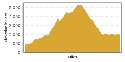
Shortly afterwards, you cross into North Carolina and the Nantahala National Forest, and the road changes to NC-143. Take advantage of the many pullouts which offer amazing, expansive views of the cloud-draped Great Smoky Mountains. At 5,390 feet of elevation, Santeetlah Overlook (V1), is the highest point on this drive and also a wonderful spot to picnic.
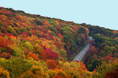
The scenic byway is spectacular year-round and the autumn palette is unparalleled. Crimson, oranges, and yellows light the forest ablaze with beauty.
Continuing west, consider a side-trip onto Joyce Kilmer Road (T1). Honoring the famous poet for the line, “I think that I shall never see a poem lovely as a tree” — this 2-mile stretch of road represents his sentiments perfectly. Explore the nearby Joyce Kilmer Memorial Forest. At 3,800 acres, it is now the largest stand of old growth trees in the eastern United States. Hike the easy 2-mile Joyce Kilmer Recreation Trail to experience the magnificence of these untouched trees, some over 400 years old.
The scenic drive comes to an end as you approach the town of Robbinsville. From here, consider traveling north on NC-28 to Almond, then north on US-19 towards Cherokee where you can head over the Smoky Mountains on Newfound Gap Road through the Smoky Mountains National Park.


