

Colorado River Scenic Byway
Through the Sandstone Canyons
| Mileage | 41 miles (66 km) |
|---|---|
| DurationThe duration is an estimate of a one-way drive and does not include any stops or side-trips. | 50 minutes |
| SeasonsThe seasons listed are the best seasons for this scenic drive. If Winter is not mentioned, the road may be closed during the winter. | All Seasons |
| Roadways | Utah Highway 128 |
| PassesSome of the adventures on this scenic drive require an admission fee that these passes cover. Please read the drive description for more information. | America the Beautiful Resident Annual National Parks Pass 2026-2027 |
| ServicesThe cities or towns listed have either Food or Services such as gas, pharmacies, etc. | Moab, UT▼ |
| Rating | 3.7 average from 50 votes |
| My DrivesTrack your favorite scenic drives by selecting those which you want to take and those that you have taken. Using your free account, simply sign in and select My Drives. | |
| Share |

Our free Road Trip Planner will reverse the route and include the places of interests. Click the “Add to Road Trip” above to start planning your next road trip.
Send this link to your phone. Standard text messaging rates apply.
() -Get directions from your start address to the beginning of and including this scenic drive. Choose either an alternate ending or same as start.
Have more destinations? Use our free Road Trip Planner to completely plan your adventure. Click the “Add to Road Trip” above to start planning your next road trip.
Get a Park Pass
Natural areas along this route require an entrance fee used to protect and maintain our most scenic treasures. Save time by purchasing your forest passes before you go.
The Colorado River has been deftly carving chasms for millions of years, leaving red sandstone cliffs looming. Though we love scenic driving, rafting or swimming in the warm, muddy waters of the Colorado River is a great way to get up close.
The scenic drive begins just east of the town of Moab, known for its proximity to Canyonlands National Park, Arches National Park, and many outdoor activities. To reach it, take exit 182 off of I-70. In 20 miles, UT-313 will be on your right.
In 14-miles from US-89 you arrive at Canyonlands National Park (H5). Canyons, mesas and buttes carved by water and erosion make for spectacular scenery. The park is divided into four districts by the Green and Colorado Rivers, the Island in the Sky, the Maze, the Needles, and the rivers each with their own distinct personalities and much to explore. Due to the large expanse of the park it is impractical to visit more than one or two districts in a single trip. For day trips, the island in the Sky area is the most accessible. Five miles from the Visitors center is the trailhead for Mesa Arch. A half mile round trip hike brings you to the incredible Mesa Arch spanning 90 feet at the edge of a mesa precipice thousands of feet above the Colorado River Gorge. A great scenic side trip is the drive to Grand View Point. Many pullouts offer opportunities to marvel at the wondrous landscape. Flat-topped mesas, scarred terrain, unusual rock formations might seem like you’re on another planet. Take advantage of the many short hikes and fabulous panoramas from the many overlooks. You can easily spend a whole day or more here so plan accordingly.
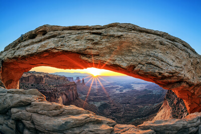
In 6-miles from the UT-313, Arches National Park (H1) is on your left, where more than 2,000 arches and sculptures are found. Early explorers believed were ancient civilization ruins, but are in fact completely natural. As for all the National Parks, there is so much to explore, an entire day or even more if possible is needed to truly immerse yourself in the wonders they have to offer. There are a great many hikes here with a variety of levels. During the hot summer months hikes are best done early or late in the day. For a two hour round trip hike we suggest the Delicate Arch Trail from Wolfe Ranch, or the easy walking trail hike between the sandstone fins in the Devils Garden to see Landscape Arch. There are wonderful scenic drives as well through the park. Drive to the Windows section to see some of the park’s largest arches or drive to the Delicate Arch Viewpoint to view the world’s most famous arch. There are many pullouts and viewpoints throughout so have your camera ready to capture the surreal and beautiful scenery in this photographer’s paradise.
In 3-miles from the entrance to Arches National Park, you will cross the Colorado River and the start of our drive is on the left UT-191. The scenic drive heads into the beautiful red-orange canyon. A chance to explore these canyons is in a few miles at the Negro Bill Canyon, where a 2-mile hike brings you through an impressive canyon, behold a mix of red sandstone walls and lush green canyon bottom due to a stream that culminates with the Morning Glory Natural Bridge, the sixth longest natural bridge in the United States.
A few miles after this canyon, the Colorado River swerves around like an elbow. Here the Big Bend Recreation Area (H3) is an ideal location to enjoy a picnic on the Colorado River’s white sandy beach. The river is dangerous for swimming due to strong currents and undertows. Instead enjoy the views of the white water rafters passing by and the spectacular surrounding canyon landscape.
In 5-miles from here, keep an eye out for Castle Valley Road (T1) which will bring you closer to the La Sal Mountains and Castle Rock. While the road does eventually turn to gravel, we do recommend at least doing the non-gravel portion of the road. Fascinating rock formations of all textures and colors will delight. Taking the complete road will bring you back to Moab.
As you continue on UT-128, you will see the soaring pinnacles of Fisher Towers in the distance. A 2.2-mile side trip on a well-marked gravel road leaves the UT-128 and heads towards the Fisher Towers Recreation Area (H4). Views of the pinnacles, including the 900-foot tall Titan, are simply spectacular. Made of Cutler sandstone and caked with a stucco of red mud, the Towers are a well-known backdrop for movies and still photography and the oddly-shaped spires make for great rock climbing. While you are here, enjoy a 2-mile hike that heads through the canyons where you will be rewarded with sweeping awe-inspiring views of Onion Creek Canyon. To do this and any hikes in the area, make sure you bring plenty of water and wear layers of clothing as the weather changes frequently.
When the UT-128 crosses over the Colorado River again, you will see the ruins of the 1916 wood-and-iron Dewey Suspension Bridge which burned in 2008. Shortly thereafter, our scenic drive comes to an end.

Other Nearby Places of Interests
Negro Bill Canyon (H2): A 2-mile hike from the Negro Bill Canyon brings you through a beautiful canyon that ends with a spectacular view of the Morning Glory Natural Bridge.
John Wesley Powell River History Museum (M1): The John Wesley Powell River History Museum present information about the explorers and importance of the Green River.
Sego Canyon Rock Art Site (M2): The Sego Canyon Rock Art Site is adjacent to the Sego Ghost Town and features petroglyphs from 500 B.C. Please be sure not to touch any of the panels.
Share
 | ||||||
| Sun | Mon | Tue | Wed | Thu | Fri | Sat |
|---|---|---|---|---|---|---|
Send this link to your phone. Standard text messaging rates apply.
() -