
Mount Adams Drive
A drive through the forest to Mount Adams
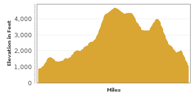
| Mileage | 62 miles (101 km) |
|---|---|
| DurationThe duration is an estimate of a one-way drive and does not include any stops or side-trips. | 3 hours |
| SeasonsThe seasons listed are the best seasons for this scenic drive. If Winter is not mentioned, the road may be closed during the winter. | Summer, and Fall |
| Roadways | Forest Roads 21, 2160, 23, 2329, and 56, Washington Highway 131, and Cispus Road |
| Gravel Roads | Yes |
| PassesSome of the adventures on this scenic drive require an admission fee that these passes cover. Please read the drive description for more information. | Northwest Forest Passes (Washington, Oregon) |
| ServicesThe cities or towns listed have either Food or Services such as gas, pharmacies, etc. | Packwood, WA▼ |
| Rating | 3.8 average from 110 votes |
| My DrivesTrack your favorite scenic drives by selecting those which you want to take and those that you have taken. Using your free account, simply sign in and select My Drives. | |
| Share |

Our free Road Trip Planner will reverse the route and include the places of interests. Click the “Add to Road Trip” above to start planning your next road trip.
Send this link to your phone. Standard text messaging rates apply.
() -Get directions from your start address to the beginning of and including this scenic drive. Choose either an alternate ending or same as start.
Have more destinations? Use our free Road Trip Planner to completely plan your adventure. Click the “Add to Road Trip” above to start planning your next road trip.
Get a Park Pass
Natural areas along this route require an entrance fee used to protect and maintain our most scenic treasures. Save time by purchasing your forest passes before you go.
Mount Adams is one of the forgotten mountains throughout history. When Lewis and Clark visited this area in the 1800s, they made no mention of it, possibly thinking that it was Mount Saint Helens. Mount Adams has not erupted in more than 1,400 years, however, it is still considered potentially active.
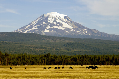
Although it is now the second highest mountain of the Cascade Range, Mount Adams is one of the least developed of the Cascades making this more of a hike for your car than a drive since this is a mix of paved and unpaved roads.
This drive starts in Randle and ends near Packwood. From I-5, take exit 68 and travel US-12 east until you reach Randle, where the Cowlitz Valley Ranger District (I1) is.
From US-12, turn south on WA-131 and in 2 miles, turn left onto Cispus Road. The road will go through various farms and orchards until it reaches the Gifford Pinchot National Forest, where the road becomes Forest Road 23. You are now driving through an old growth forest where the trees range from 250 to 300 feet tall. Keep a watchful eye for wildlife as this untamed wilderness has creatures of many sizes.
In another three miles, you will reach Layser Cave (H1). Just 800 feet from the parking area, this fascinating archaeological site gives you a glimpse into the history of the prehistoric people who lived here.
Eight miles from Layser cave, the short, quarter mile Camp Creek Falls (H2) Trail brings you to the Camp Creek Falls that fall over a rocky ledge down 30 feet.
15 miles after the road joins up with the Cispus River, you will start seeing views of the snow capped Mount Adams. A few miles later, Takhlakh Lake (H3) is a great spot for pictures, picnics, and a 1-mile loop trail around the lake. Other hikes are accessible from here.
Forest Road 2329 will follows young and old forests and ancient lava flows on the northern-most edge of the Mount Adams Wilderness, and Mount Adams is frequently visible.
The drive will turn onto Forest Road 56 about ten miles from Takhlakh Lake. About one mile later, take a left onto Forest Road 2160, and after two miles, turn right onto Forest Road 21. After driving through more old growth forests, the drive ends just south of Packwood.
From here, consider continuing up US-12 to Mount Rainier, Chinook Scenic Byway, or the White Pass Scenic Byway.

Other Nearby Places of Interests
Ape Cave (H4): Ape Cave is a the longest continuous lava tube in the continental United States and offers wonderful views of Mount St. Helens lahar region.
Share
 | ||||||
| Sun | Mon | Tue | Wed | Thu | Fri | Sat |
|---|---|---|---|---|---|---|
