
Rim of the World Scenic Byway
Through the San Bernardino Mountains
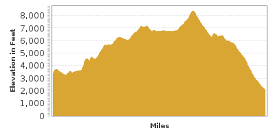
| Mileage | 100 miles (161 km) |
|---|---|
| DurationThe duration is an estimate of a one-way drive and does not include any stops or side-trips. | 2 hours, 16 minutes |
| SeasonsThe seasons listed are the best seasons for this scenic drive. If Winter is not mentioned, the road may be closed during the winter. | All Seasons |
| Roadways | California Highways 138, 18, and 38 |
| PassesSome of the adventures on this scenic drive require an admission fee that these passes cover. Please read the drive description for more information. | Southern California Forest Adventure Passes |
| ServicesThe cities or towns listed have either Food or Services such as gas, pharmacies, etc. | Phelan, CA▼, Crestline, CA▼, Running Springs, CA▼, Mentone, CA▼, and Big Bear Lake, CA▼ |
| Rating | 4.1 average from 259 votes |
| My DrivesTrack your favorite scenic drives by selecting those which you want to take and those that you have taken. Using your free account, simply sign in and select My Drives. | |
| Share |

Our free Road Trip Planner will reverse the route and include the places of interests. Click the “Add to Road Trip” above to start planning your next road trip.
Send this link to your phone. Standard text messaging rates apply.
() -Get directions from your start address to the beginning of and including this scenic drive. Choose either an alternate ending or same as start.
Have more destinations? Use our free Road Trip Planner to completely plan your adventure. Click the “Add to Road Trip” above to start planning your next road trip.
Get a Park Pass
Natural areas along this route require an entrance fee used to protect and maintain our most scenic treasures. Save time by purchasing your forest passes before you go.
Head through the San Bernardino Mountains, passing Lake Arrowhead and Big Bear Lake on your way from Phelan to Mentone. You can reach Phelan from I-15. If you are coming from the south, take the exit after 129 for CA-138.
For a short detour before starting the drive, head west on CA-138 to the Mormon Rocks (H1). Behind the Mormon Rocks Fire Station is a .5-mile trail through the desert that brings you to a bed of uplifted sandstone.
Heading east on CA-138 from here, you will soon arrive at the Cajon Pass Overlook (V1), where rail fans, photographers and history buffs come to experience the BNSF Railroad trains heading up the pass. The pass was created by movements of the San Andreas Fault and the rich geologic history is evident.
Continuing east on CA-138, you will reach the Silverwood Lake Overlook (V2) which provides a view onto the reservoir lake created in 1971 when Cedar Springs Dam was built. The nearby Silverwood Lake Recreation Area (H2) offers swimming, fishing, boating, hiking, and picnicking by the lake.
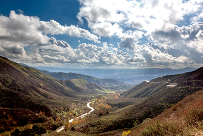
In 5-miles, the drive starts gaining elevation and meanders up and around the mountain. In 11 miles from Silverwood Lake, you arrive in Crestline and shortly after, the CA-138 joins up with the CA-18. This drive heads east on CA-18. Take advantage of the turnouts or the Baylis Park Picnic Area (H3) for a spectacular view of the San Bernardino Valley with the Santa Ana Mountains to the southwest and the San Jacintos Mountains to the southeast.
A short side-trip on CA-173 will lead you to Arrowhead Lake (W1). The lake is surrounded by trees and offers swimming and picnicking opportunities.
Continuing east, stop at Heaps Peak Arboretum (A1) where you can learn about the trees within the San Bernardino National Forest. There is a beautiful, one-mile handicap and stroller accessible trail featuring Arizona cypress, giant sequoia, sugar, knobcone, and coulter pines, black oak, quaking aspen, and white fir. Between March and October, enjoy an array of colorful wildflowers. The Arboretum is free although a Southern California Adventure Pass or America the Beautiful Pass is required for all vehicles in the Aboretum parking lot.
After Running Springs, consider a short side-trip on Keller Peak Road (T1). The twisty 4-mile road will bring you to the National Children’s Forest and Keller Peak Fire Lookout. The tower overlooks the 53,000 acres that burned in 1970 and the Children’s fundraising efforts to replant the area with trees.
Continuing on CA-18, Lake View Point (V6) offers a magnificent view of Big Bear Lake and the surrounding mountains. The road then leads to Big Bear Dam, where you can either continue on CA-18 for a south-view of the Big Bear Lake or head onto CA-38 for a north-view of the lake. Accessible from the north side, the Big Bear Solar Observatory (A2) rises from the lake like a robot. The world’s largest solar telescope, it studies solar power and the solar system. On the lake, you can enjoy swimming and boating. The Grout Bay Picnic Area (H4) offers a chance to see the birds of the area, including bald eagles. Again, your Adventure Pass is required to park here and on all national forest lands.
After the lake, head south on CA-38 which meanders down towards Mentone where this drive completes. Alternatively, continue on CA-18 for the Bear Lake Loop (T2) which will bring up around the San Bernardino Mountains to Victorville where you can reach the I-15.
At the end of the drive in Montone, consider heading south on CA-210 and then west to Joshua Tree National Park.

Other Nearby Places of Interests
Barton Flats Visitor Center (I2)
Mill Creek Ranger Station (I3)
Big Bear Ranger Station and Discovery Center (I5)
Strawberry Peak Lookout (V4): From CA-18, head north on Bear Springs Road and Strawberry Peak Road will be on your left in about a mile.
Share
 | ||||||
| Sun | Mon | Tue | Wed | Thu | Fri | Sat |
|---|---|---|---|---|---|---|
Send this link to your phone. Standard text messaging rates apply.
() -