

Silverado Trail
Through the Napa Valley wine region
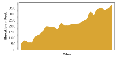
| Mileage | 26 miles (43 km) |
|---|---|
| DurationThe duration is an estimate of a one-way drive and does not include any stops or side-trips. | 1 hour |
| SeasonsThe seasons listed are the best seasons for this scenic drive. If Winter is not mentioned, the road may be closed during the winter. | Spring, Summer, and Fall |
| Roadways | Silverado Trail Road |
| ServicesThe cities or towns listed have either Food or Services such as gas, pharmacies, etc. | Yountville, CA▼, Napa, CA▼, Calistoga, CA▼, and St Helena, CA▼ |
| Rating | 3.8 average from 132 votes |
| My DrivesTrack your favorite scenic drives by selecting those which you want to take and those that you have taken. Using your free account, simply sign in and select My Drives. | |
| Share |

Our free Road Trip Planner will reverse the route and include the places of interests. Click the “Add to Road Trip” above to start planning your next road trip.
Send this link to your phone. Standard text messaging rates apply.
() -Get directions from your start address to the beginning of and including this scenic drive. Choose either an alternate ending or same as start.
Have more destinations? Use our free Road Trip Planner to completely plan your adventure. Click the “Add to Road Trip” above to start planning your next road trip.
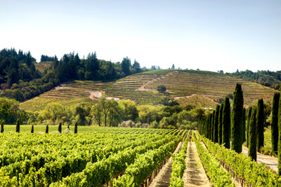
The Silverado Trail travels through the Napa Valley wine region on a road originally built in the 1850s during the silver rush. Running parallel to CA-29, discover exceptional wineries amid rolling hills and mountains on a road less traveled. Along the way are dozens of exceptional wineries open for tasting and exploring, including Clos du Val, Judd's Hill, Mumm Napa, Signorello Estate Winery, and Stag's Leap Wine Cellars. Some wineries offer dining options to complement your experience, and others have picnic tables, so pack some fresh bread and specialty cheese, and relax with a glass of wine while soaking in the stunning views. Remember, please drink responsibly and plan at least one overnight to truly appreciate all this region has to offer.
This scenic drive starts in Napa and heads northwest to Calistoga. To reach Napa from San Francisco, head north on I-80/CA-123, take exit 33 for CA-37 West, and then take exit 19 for CA-29. In 7 miles, turn right for CA-221 North and in 2.5 miles, Silverado Trail will be on your right. In 2.5 miles, turn left on Monticello Road and right at the next block to stay on Silverado Trail.
Heading northwest on Silverado Trail, you will soon be surrounded by fields of grapevines, first, Chardonnay and 8-miles further in Yountville, Cabernet Sauvignon. Yountville is named for George Yount, who first planted grapes in 1838. The town is also known for its culinary artistry, offering a wide variety of cuisines from down-home comfort food to upscale dining. Premium wineries, shopping, galleries and hot-air balloon tours make this a worthy side trip.
In Yountville, stop at the Napa River Ecological Reserve (H1) where you can walk through the California bays, oak, and willow trees and have a chance to spot some of the more than 150 bird species that reside here.
As you continue north on the Silverado Trail, parts of the Coast Range mountains emerge around you. The mountains were formed as the tectonic plates collided below and buckled the land, spewing lava and ash throughout the land, resulting in the rich soil the valley has today.
The drive concludes as you approach CA-29 and arrive in Calistoga, known for its hot springs and mineral pools. You can see the volcanic history in Calistoga by visiting the California’s Old Faithful Geyser (H2) which erupts steam and bubbling water 60 feet in the air every 40 minutes. The Sharpsteen Museum (M2) presents the history of the Napa Valley through elaborate dioramas.
From here, you can head North on CA-29 and head to Robert Louis Stevenson State Park (H3) where a 5-mile trail will bring you to the top of Mount St. Helena, where you can see San Francisco and on clear days, you can even see Mount Shasta.
Or you can head over to the Northern Pacific Coast near Jenner by heading south on Petrified Forest Road from CA-128 just after Calistoga. In 4 miles, turn right onto Porter Creek Road. This will become Mark West Spring Road and then River Road/CA-116 until you reach CA-1. This usually takes around an hour.

Other Nearby Places of Interests
Robert Louis Stevenson Silverado Museum (M1): Robert Louis Stevenson Silverado Museum celebrates Stevenson’s life and work.
Share
 | ||||||
| Sun | Mon | Tue | Wed | Thu | Fri | Sat |
|---|---|---|---|---|---|---|
