

Going to the Sun
Glacier National Park
| Mileage | 47 miles (77 km) |
|---|---|
| DurationThe duration is an estimate of a one-way drive and does not include any stops or side-trips. | 1 hour, 24 minutes |
| SeasonsThe seasons listed are the best seasons for this scenic drive. If Winter is not mentioned, the road may be closed during the winter. | Spring, Summer, and Fall |
| Roadways | Going To The Sun Road |
| ServicesThe cities or towns listed have either Food or Services such as gas, pharmacies, etc. | Coram, MT▼, Browning, MT▼, Apgar, MT▼, and St. Mary, MT▼ |
| Rating | 4.1 average from 38 votes |
| My DrivesTrack your favorite scenic drives by selecting those which you want to take and those that you have taken. Using your free account, simply sign in and select My Drives. | |
| Share |

Our free Road Trip Planner will reverse the route and include the places of interests. Click the “Add to Road Trip” above to start planning your next road trip.
Send this link to your phone. Standard text messaging rates apply.
() -Get directions from your start address to the beginning of and including this scenic drive. Choose either an alternate ending or same as start.
Have more destinations? Use our free Road Trip Planner to completely plan your adventure. Click the “Add to Road Trip” above to start planning your next road trip.
Head through all of the scenic wonders of Glacier National Park. From the glacier-formed turquoise Lake McDonald and Lake St. Mary, the old-growth forests, regions of forest fires, and all surrounded by endless mountain peaks.
This scenic drive can be done in either direction, but we describe it as starting in Apgar and ending in St. Mary. You can reach Apgar by US-2 towards West Glacier and turning north on the Glacier Route 1/Going-to-the-Sun Road. To start in St. Mary, use US-89.
Heading east on Going-to-the-Sun Road from Apgar, follow the signs towards Apgar Village where you will be rewarded by views of Lake McDonald (W1) and mountains in the distance. Continuing east, Lake McDonald will be on the north side of the Going-to-the-Sun Road for the next 10-miles, although it will not always be visible. Take advantage of the many turnouts to view the lake and the surrounding beauty. Along the lake are several beaches that are perfect for picnics.
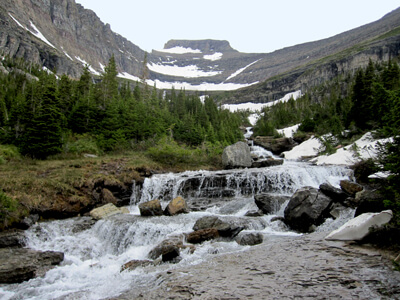
At the north end of the lake, stop for the McDonald Falls (V1), one of Glacier National Park’s largest waterfalls. In a half of a mile, a short hike will bring you to the Sacred Dancing Cascade (H1), a series of cascading waterfalls through the rapids.
The drive continues through the forests with mountain views. In 4-miles, you arrive at Avalanche Creek where you can take the Trail of the Cedars (H2) a 1-mile loop trail that heads through cedar and hemlock forests across a bridge over Avalanche Gorge. Attached to the trail is a 2-mile trail that leads to the picturesque Lake Avalanche.
Back on the road for a mile, stop at the Red Rock Point (H3) where a short walk leads to where McDonald Creek makes its way through red mudstone.
On the right-side of the road, Mount Cannon will be visible and at Avalanche Exhibit (V2), you can see the avalanche chutes.
Continuing east on Going-to-the-Sun Road, the road takes a sharp right turn and leaves the McDonald Creek behind. Stop here for incredible panoramic views.
There are many great pullouts to take advantage of the majestic beauty of nature. One such stop is in 2.5-miles from the turn which overlooks McDonald Valley and Bird Woman Falls, a waterfall that cascades off the valley created by Mount Oberlin, Mount Clements, and Mount Cannon.
Heading east, you will see Garden Wall, the Continental Divide within Glacier National Park. The melting glaciers feed the Pacific Ocean, the Hudson Bay, and even the Gulf of Mexico. You will also notice that the west side of the Continental Divide is more like the Pacific Northwest rain forests while the east side is typically drier and cooler.
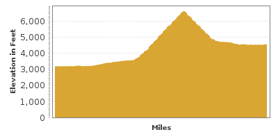
In 5-miles you arrive at the 6,646 feet high Logan Pass where mountains seemingly float atop meadows of alpine wildflowers. Stop at the Logan Pass Visitor Center (I1) for information. There is an observation deck and many trails. Hidden Lake is a very popular 1/5 mile trail providing magnificent views in every direction. Wildlife abounds; mountain goats, big horn sheep and even an occasional bear are common sightings.
In five cliff-hanging miles, stop at the Jackson Glacier Turnout (V4) for a commanding view of Jackson Glacier. Jackson Glacier is currently about a quarter of the size that it was in the 1850s. It is projected that in 10 years, all the glaciers in the park will be gone.
In two miles, consider a hike to Saint Mary Falls (H4). A 1.5-mile hike will bring you to one of the most beautiful waterfalls in Glacier National Park. Virginia Falls can be seen across the Saint Mary Lake.
The drive now parallels St. Mary Lake for the final 10-miles. Two miles from where the lake begins, stop at Sun Point (V5) which offers postcard perfect views of St. Mary Lake. A short path brings you to an overlook where you can marvel at the beauty of the lake surrounded by mountain peaks.
Towards the middle of the lake, stop at Wild Goose Island Viewpoint (V6) where you can see the small island in the middle of the Saint Mary Lake and the surrounding beauty.
The drive continues along the lake until you reach St. Mary. From here, consider heading south on US-89 to Yellowstone National Park and a side trip on the Looking Glass Hill Road.

Other Nearby Places of Interests
Bird Woman Falls Overlook (V3): This vista point overlooks the McDonald Valley and the Bird Woman Falls which cascades off the valley created by Mount Oberlin, Mount Clements, and Mount Cannon.
Share
 | ||||||
| Sun | Mon | Tue | Wed | Thu | Fri | Sat |
|---|---|---|---|---|---|---|
Send this link to your phone. Standard text messaging rates apply.
() -