
Blue Ridge Parkway
Along the Southern Appalachian Mountains

Our free Road Trip Planner will reverse the route and include the places of interests. Click the “Add to Road Trip” above to start planning your next road trip.
Send this link to your phone. Standard text messaging rates apply.
() -Get directions from your start address to the beginning of and including this scenic drive. Choose either an alternate ending or same as start.
Have more destinations? Use our free Road Trip Planner to completely plan your adventure. Click the “Add to Road Trip” above to start planning your next road trip.
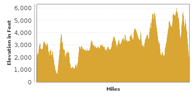
One of the most popular scenic drives in the United States, the Blue Ridge Parkway travels along the southern Appalachian Mountains, connecting Shenandoah National Park in Virginia to Great Smoky Mountains National Park in North Carolina. The cliff-hugging road offers sweeping views, fascinating and diverse flora and fauna, geologic wonders and a myriad of recreation opportunities. Spectacular in any season, the Parkway is renowned for its fall foliage which displays a vivid palette of color. Sections of the Parkway may be closed in winter; it is advisable to check for up-to-date road conditions before heading out.
This scenic drive begins in Rockfish Gap, Virginia. To reach Rockfish Gap, take exit 99 from I-64. From Rockfish Gap, the road climbs offering expansive vistas as it weaves through unparalleled natural beauty. Take advantage of more than 200 overlooks along the Blue Ridge Parkway each one offering its own glimpse of treasure.
This National Scenic Byway and “All-American Road” began construction in 1935 during the administration of FDR and took over 52 years to complete. Stop at Humpback Rocks (A1) Visitor Center to learn about the early pioneer history and tour a series of nineteenth-century farm buildings by taking the easy 1/4-mile Mountain Farm Trail. Outstanding views can be had by hiking the Humpback Rocks Trail. The 2-mile round trip up the massive greenstone outcrop is short, steep but well-worth the effort.
The road winds along a few creeks until it opens up at Otter Lake (W1). This man-made lake with a waterfall is popular with anglers and features a handicap accessible fishing pier.
As you continue south, stop at Buena Vista Overlook (V3). As you gaze upon the endless rolling hills, keep in mind that the Appalachian Mountains were once as high as the Alps and Rockies, created in a similar manner, but now eroded.
Across the road from the Slacks Overlook parking is the start of a 1.8-mile trail to the picturesque White Rock Falls. Named for the region’s surrounding quartz rock, traverse the serene forest to view the impressive gorge and 35-foot waterfall. Don’t miss the small side trail that leads to a great view of the falls.
The road descends to the lowest point along the entire route near James River. The James River Visitor Center (I1) features exhibits and a short trail leads to a restored 19th-century canal lock. Enjoy views of the James River Canal, said to have been conceived by George Washington. The James River Canal connects the Ohio River to the Atlantic Ocean and was a major artery during the Civil War to move supplies. The James River Ranger Station (I2) is up the hill from here.
Consider a detour to Natural Bridge State Park in Rockbridge County. The unique limestone bridge which spans Cedar Creek was formed when a cavern collapsed. The site was designated Virginia's 37th State Park in 2016. While here, take the 1-mile Cedar Creek Trail to Lace Falls.
From James River, the road winds and climbs its way up to the highest point of the drive in Virginia at 3,200 feet of elevation ’ in a mere 25 miles. Apple Orchard Mountain, the highest and most prominent peak along the Parkway, is named for the red oak trees that look like an apple orchard from a distance. Stop at Sunset Field Overlook and hike to the beautiful Apple Orchard Falls (H1). The 200-foot cascade is dazzling but requires a steep, strenuous 2.8-mile round trip hike, changing 1,000 feet in elevation. Don’t fret if you’re not up for this hike as there are many other falls along this route.
Continuing on the Blue Ridge Parkway, consider a stop at the Fallingwater Cascades Trail (H2). The 3.2-mile round trip moderate hike through mixed forest, wildflowers and flowering rhododendron rewards with a spectacular waterfall that bounces off several rocks faces.
Back on the road you arrive at the Peaks of Otter Visitor Center (I3) where the classic Appalachian landscape and Abbot Lake nestled in a valley between Sharp Top and Flat Top have attracted people for ages. Wildflowers and wildlife abound with chances to spot Box Turtle, Woodchuck, Black Rat Snake or Cottontail Rabbit. Look back in time with a visit to Polly Woods Ordinary, an original log cabin used by travelers from the 1820s to 1850s or The Johnson Farm, accessed by the 1.8-mile loop Johnson Trail, and features costumed interpreters and programs. There are many other trails to explore such as the popular Sharp Top Trail and the incredible Flat Top Trail, which scrambles over boulder fields and passes fascinating rock formations that defy gravity as they balance precariously. Among the services at Peaks of Otter is a gas station, restaurant and camping.
The next segment of road unfolds breathtaking views with every curve. As you approach the town of Roanoke, consider a side trip to Explore Park (H3). Discover 1100 acres of natural beauty with a wide variety of recreation opportunities such as, hiking, mountain biking, and canoeing or kayaking. Explore Park also houses the Blue Ridge parkway Visitors Center. Roanoke is the largest community along the Parkway and features a thriving art scene, unique shops, galleries and eclectic restaurants. The Taubman Museum of Art (M1) focuses on American art and the contemporary building reflects a modern interpretation of the surrounding mountainous landscape.
Soon on the left, Roanoke Mountain Road (T1) is a 3.7-mile one-way road that affords impressive views from seven overlooks. There are steep grades and towed vehicles are prohibited. Culminate the experience by hiking the short Roanoke Mountain Summit Trail.
Back on the Parkway, the road climbs the Blue Ridge Plateau displaying endless views of farmland. Bird enthusiasts should consider a detour to Smart View Recreation Area (H4) where a variety of trails offer superb vantage points to observe birds during spring migration and summer breeding, such as the Acadian flycatcher, scarlet tanager and the cerulean warbler. Meandering the forest as well is the red-spotted newt, red fox and white-tailed deer. Enjoy a picnic amidst views of the Virginia Piedmont or walk to the log Trail Cabin built in the 1890s.
The Rocky Knob Visitor Center is another full service area with gas, restaurant, picnic tables, camping and cabin rentals built by the Civilian Conservation Corps in the 1930s. Hike into Rock Castle Gorge on the moderate to strenuous 10.8 mile loop trail beginning at the Rocky Knob Campground. No need to do the entire loop to experience this sublime hardwood forest of oak, hickory, magnolia and aspen or the delightful creek. Those who continue on will travel through extensive boulder field known as Bare Rocks and enjoy the impressive views of the Gorge. The Rocky Knob Picnic Loop Trail is an easy 1-mile scenic walk with many wildlife watching opportunities.
Mabry Mill (A2) was used between 1920 and 1935 and this picture perfect mill is one of the most photographed structures along the parkway. Here you will find a restored gristmill, sawmill, woodworking and blacksmith shop and more. The pastoral setting captures the imagination as you learn about the lives of the early settlers through interpreters and on-site with demonstrations like basket weaving, spinning and weaving.
Just ahead, follow the road for Groundhog Mountain (A3) where you can learn and see the unique types of farm fences once used in the region such as Post and Stake, Virginia Snake, Cross-Buck and more. Revel in the stunning 360-degree views from the Groundhog Mountain lookout.
Shortly afterwards, stop at the Aunt Orelena Puckett Cabin (A4), home of Orelena Hawks Puckett who became a midwife who helped deliver over 1000 babies until she died at 102 years of age.
Continuing southwest, the oddly-capped Pilot Mountain, a remnant of the ancient Sauratown Mountains looms into view. In the town of Galax, don’t miss visiting the Blue Ridge Music Center (A5) which features an outdoor amphitheater and an interpretive center which showcases the roots of American Music. The Mid-Day Mountain Music concerts from noon to 4pm are free.
Shortly after this, you cross into North Carolina where the Parkway travels at a higher in elevation and through the Pisgah National Forest. Cumberland Knob is where construction of the Blue Ridge parkway began. The Visitor center features exhibits and a variety of hikes leave from here.
Stop at Fox Hunters Paradise Overlook (V5) and don’t miss the short spur road that leads to High Piney Spur where a flat, paved trail leads to an incredible view from a stone observation deck.
Continuing on the Parkway, Mount Jefferson comes into view to the west. The road then descends into Deep Gap, a rugged area known only to the Cherokee until Daniel Boone explored it in the late 1700s. Further up the road, shop for local arts, crafts and baked goods at the Northwest Trading Post (A6).
Visit the Moses H. Cone Memorial Park (H5) just past the town of Blowing Rock. Built by Moses H. Cone, known as the “Denim King,” this beautiful 23-room, 13,000 square foot estate is a wonder to behold. Situated on 3,600 acres, explore miles of carriage trails through forest, magnificent orchards and trout-stocked lakes. The Parkway Craft Center located here features handmade crafts by regional artists. The estate, named Flat Top Manor, is free to enter.
Continuing south, Grandfather Mountain (H6) appears in the distance. One of the oldest mountains in the world and containing quartz created over a billion years ago, Grandfather Mountain was once taller than Mt. Everest, now diminished by erosion. You can drive to Grandfather Mountain by taking US-221 west and winding your way up. There is a fee to enter Grandfather Mountain that the not-for-profit corporation uses to preserve the mountain. Don’t miss the Mile High Swinging Bridge. Built in 1952, the accessible 228-foot suspension bridge spans an 80 foot chasm offering breathtaking panoramic views. Environmental habitats and aquarium-like viewing allow visitors to see otters, bear, cougars, deer and other species up close. Explore trails, experience a naturalist program and treat yourself to something sweet at the Fudge Shop.
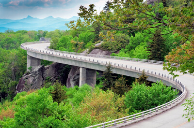
Shortly after getting back on the road, you arrive at the newest portion of the Blue Ridge Parkway. This 7.7-mile of roadway was completed in 1987, specifically constructed to minimize the environmental impact on Grandfather Mountain. The Linn Cove Viaduct features sweeping curves that wind gently around the mountain. Learn more about the design and construction of the bridge at the Linn Cove Visitor Center (I6) at the south end of the viaduct. From there, take the one-mile roundtrip hike underneath the viaduct, offering close-up views of this engineering marvel and access to the Tanawha Trail. Whether you explore all or just a portion of the 13.5-mile Tanawha Trail which travels from Julian Price Park to Beacon Heights, you will be rewarded with spectacular and diverse views of forest, rock formations, small cascades and wildflowers.
Stop at Linville Falls (H7), accessed by a short spur road off the Parkway. Explore the Upper and Lower Linville Falls as they plunge into the rugged 12-mile long Linville Gorge, one of the deepest scenic gorges in the eastern United States. Hike one of the trails that leave from the Visitors Center and enjoy spectacular beauty, cool dense forests and large rocks for lounging on when the hiking is done. Swimming is not permitted due to swift currents. Thanks to local landowners and John D. Rockefeller, Jr., this area is one of the rare places in the United States that has preserved the virgin forests that once covered the entire east coast, making this an extra special hiking experience.
As the Black Mountains come into view, consider stopping at the Crabtree Meadows Recreation Area where the short, albeit steep Crabtree Falls Trailhead from the campground leads to the unforgettable 70-foot Crabtree Falls (H8).
Crabtree Meadows marks the last stretch of the Parkway through the Blue Ridge Mountains before it turns westward into the Blacks, Craggies, Pisgahs and Balsams before entering Great Smoky Mountains National Park. From here, the road climbs again and expansive jaw-dropping views await. Trees change from spruce to fir and in several miles.
Visit Mount Mitchell State Park (H9). Mount Mitchell is the tallest mountain east of the Mississippi, standing at 6,684 feet of elevation. A short side-trip allows you to drive to the summit where you can enjoy spectacular views and recreational opportunities. Keep in mind that the weather at the top is much cooler and that snow can last late into the summer. The cooler temperature, more typical of a boreal forest, is home to rare and uncommon plant and animal species. The Natural History Museum located on the way to the Stone Observation Tower features dioramas and exhibits of the higher elevation plants and wildlife.
Back on Blue Ridge Parkway, you soon arrive at Craggy Dome and Craggy Gardens (H10) where the pinks and purples of Catawba rhododendrons dazzle. Mid-June is peak bloom season but this area is spectacular anytime. Stop by the visitor center, picnic among the rocky crags, exposed peaks, delicate wildflowers and at 5,500 foot elevation, unlimited views. Then stretch your legs along the easy, self-guided Craggy Gardens Trail.
As the road descends to Asheville, consider a side-trip to the Folk Art Center (A7) home to the Southern Highland Craft Guild which showcases the traditional and contemporary crafts of the Southern Appalachians. Another detour on US-25 brings you to the Biltmore Estate (A8), George and Edith Vanderbilt’s 250-room family home. An admission fee is charged which includes self-guided tours of the house, gardens, exhibits, winery, farm and more.
After Asheville, Mount Pisgah (H12) comes into view. Named for the biblical mountain Moses stood upon when he first saw the promised land, Mount Pisgah is a premier area for all types of recreation including hiking, climbing, camping, water activities, horseback riding, OHV riding and more. The 3-mile round trip hike to the summit is a great way to experience the verdant landscape.
Of the 26 tunnels along this route, 25 are within North Carolina. Always fun to drive through, Pine Mountain Tunnel is the longest at 1434 feet.
Stop at Looking Glass Rock Overlook (V7), named for the glistening reflection of water and ice on the granite face. Further up the road, Devil’s Courthouse (H13) is to the east. Among the many stories is that the rocks here were believed by settlers and Native Americans to be tombstones that hid the home of the Devil. A strenuous half-mile hike up to the peak of Devil’s Courthouse displays wondrous views all the way to South Carolina, Georgia, and Tennessee. Enjoy the delicate and rare high-altitude plants, stay on the trails and remember — Leave No Trace. Need to cool down? Skinny Dip Falls is a great swimming hole with a rock for jumping or just a place to enjoy the relaxing waterfall setting. Though the name implies more — this is not a clothing optional area.
The scenery at Graveyard Fields (H15) is strikingly beautiful — especially in fall when the hills are ablaze with color. The Graveyard Fields Loop Trail is a memorable 3.5-miles of alpine meadow, stands of Laurel and Rhododendron leading to two beautiful waterfalls where you can spend time wading in the pools.
From here the road climbs to the Overlook near Richland Balsam Trail (H14), the highest point along the Parkway at 6,053 feet of elevation. Two hikes leave from here, the Richland Balsam Hike, a 1.5-mile self-guided loop trail through a lovely, scented spruce-fir forest. The other travels through the snags of dying Fraser Fir trees that have been infested by an invasive species of insect. Learn more about this area, much like a Canadian Spruce-Fir forest and its future. This hike ends at the 6,410-foot summit.
As you approach the town of Maggie Valley, take the side-trip on Heintooga Ridge Spur Road (T2), to the must-see, Mile-High Overlook. The aptly-named perch at 5,280 feet of elevation bestows fabulous views of rolling hills against dramatic skies and the Great Smokey Mountains (including Mount LeConte and Clingmans Dome). Continuing on brings you to the Balsam Mountain Campground and Heintooga Overlook.
From here, the scenic drive snakes down until it ends at Great Smoky Mountains National Park. Continue the adventure on the Newfound Gap Road.

Other Nearby Places of Interests
Mingus Mill (A9): Mingus Mill was built in 1886 and is operational mills in Great Smoky Mountains National Park, open for tours.
Blue Ridge National Heritage Area (H11): Learn about the Blue Ridge Parkway’s history via interactive displays and videos at the Blue Ridge National Heritage Area’s Visitor Center.
Doughton Park Ranger Station (I4)
Oconaluftee Visitor Center (I5)
Museum of the Cherokee Indian (M2): The Museum of the Cherokee Indian celebrates the Cherokee Indians by showcasing their art, history, and culture.
Share
 | ||||||
| Sun | Mon | Tue | Wed | Thu | Fri | Sat |
|---|---|---|---|---|---|---|
