

Sierra Heritage Scenic Byway
The Edison Lakes
| Mileage | 67 miles (108 km) |
|---|---|
| DurationThe duration is an estimate of a one-way drive and does not include any stops or side-trips. | 1 hour, 22 minutes |
| SeasonsThe seasons listed are the best seasons for this scenic drive. If Winter is not mentioned, the road may be closed during the winter. | All Seasons |
| Roadways | CA-168 |
| ServicesThe cities or towns listed have either Food or Services such as gas, pharmacies, etc. | Clovis, CA▼, Fowler, CA▼, Fresno, CA▼, El Prado, CA▼, Riverbend, CA▼, East County, CA▼, and Lakeshore, CA▼ |
| Rating | 4.2 average from 27 votes |
| My DrivesTrack your favorite scenic drives by selecting those which you want to take and those that you have taken. Using your free account, simply sign in and select My Drives. | |
| Share |

Our free Road Trip Planner will reverse the route and include the places of interests. Click the “Add to Road Trip” above to start planning your next road trip.
Send this link to your phone. Standard text messaging rates apply.
() -Get directions from your start address to the beginning of and including this scenic drive. Choose either an alternate ending or same as start.
Have more destinations? Use our free Road Trip Planner to completely plan your adventure. Click the “Add to Road Trip” above to start planning your next road trip.
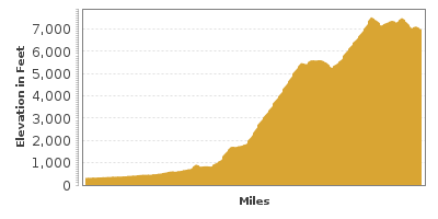
This drive stretches up out of the flat San Joaquin Valley and heads into the Sierra National Forest and the high Sierra Nevada mountains passing a series of picturesque lakes that came into being due to the need for electricity. In the early 1900s, the Big Creek Hydroelectric Project of the Southern California Edison Company built dams and tunnels, creating what are now known as the Edison Lakes. Today, vacationers flock here to relax amid beautiful high country scenery, enjoy water recreation, and hike trails for every level including the world-famous Pacific Crest or John Muir trails.
Our drive begins in Fresno heading towards Clovis “the gateway to the Sierras,” along CA-168. If you’re here the second full weekend in September, don’t miss ClovisFest, a hot air balloon festival. The free family-friendly event also features a carnival, live music, craft booths and food.
As you ascend, you will pass the turnoff to the Millerton Lake State Recreation Area and Friant Dam (H1). The 319-foot high Friant Dam was built in 1944 along the San Joaquin River which then formed Millerton Lake. The lake is a prime recreation spot for water activities such as swimming (life-guarded in summer), boating, or fishing for bass, trout, crappie and catfish. During the winter months, there is a boat tour to view nesting bald eagles. Many hiking, biking and horseback riding trails allow for exploration of live oak and blue oak forest and the river canyon. Learn about the history of the area with a tour of the old Millerton Courthouse at Mariner’s Point. The Courthouse was dismantled and reconstructed here in 1941 to protect it from rising floodwaters. Stay overnight with tent, RV and boat camping. An entrance fee is charged for vehicle day use.
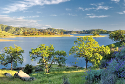
After entering the Sierra National Forest you arrive at Shaver Lake (W1), the first of the Edison Lakes. Located on the southeast end of the lake, is the town of the same name. The small population of approximately 700 people swells during summer months as recreation opportunities and a respite from hot summer temperatures draw visitors. Here you will find a variety of restaurants, shops and services. The lake was formed by damming Stevenson Creek and is named after C. B. Shaver, a pioneer lumberman who logged the area at the beginning of the 20th century. Shaver was the first to build a rock-filled dam in the area that formed a millpond to help his logging operations. Today, the lake is a mecca for water sports, such as water skiing, jet skiing, windsurfing and fishing. A public boat launch is available at the north end of the lake. Kayak and canoe enthusiasts can find secluded coves and quiet water away from power boats. There are many options for camping and cabin rentals. Southern California Edison Company constructed Camp Edison for public use along the western shore of the lake with 252 camping sites and picnic facilities. There is also an information center located here. Bird-watching abounds, with sightings of nesting warblers, woodpeckers, flycatchers and mountain quail.
Visit the Museum of the Central Sierra (M1) located in the headquarters of the Central Sierra Historical Society for exhibits on the area’s history. The Society is preserving the Pine Logging Camp and a 1912 caboose from the San Joaquin and Eastern Railroad. Experience the “Museum Without Walls”, an interesting series of lectures and field trips. The museum is open from Memorial Day to Labor Day.
Shaver Lake sits at approximately 5,500 feet of elevation, but as you continue driving on CA-168, you will ascend to almost 7,000 feet as Huntington Lake comes into view.
At Huntington Lake (W2) water sports reign supreme. Indulge in swimming, boating, water-skiing, kayaking, and canoeing. Rentals are available at Rancheria Marina. Huntington Lake is one of the top sailing lakes in California and several races are held here throughout the summer. The lake is stocked with rainbow trout or catch the native brown trout and Kokanee. A California fishing license is required and one, two day and season licenses are available at the general store in town. Look for birds and other wildlife along the shoreline. Stellar jays are abundant and they are not afraid of people and will beg for tidbits from your picnic basket. Deer are easily spotted feeding or coming down to the lake for a drink especially at dusk. This area is popular in winter as well, with snowmobiling, snowshoeing and cross-country skiing.
The nearby China Peak Mountain Resort (U1) features 1,300 acres of terrain with a 1,700 foot vertical rise. With an average snowfall of 300 inches, enjoy downhill skiing, snowboarding and tubing. The resort is open year-round and in summer, you can take the scenic chair ride to 8700-feet panoramic views. Then hike or bike the extensive trail system to the bottom. Equipment rentals are available on site.
Huntington Lake has an interesting history. The area was known as Basin prior to the existence of the lake, and cattle browsed in the basin which is now the bottom of the lake. At the bottom of the lake is a World War II B-24 plane that crashed in December of 1943 while on a training mission. It is speculated that the pilot mistook the surface of the frozen lake to be a flat meadow and when the plane lost hydraulic power during a snowstorm attempted a landing, only to sink into the depths of the freezing water.
Huntington Lake makes a great base for exploring deeper into the Sierras. Hike through the John Muir Wilderness, Ansel Adams Wilderness, and the Kaiser Wilderness and discover granite rock formations, streams, small lakes, and waterfalls all while trekking through old growth forest. Mountain bikers will enjoy the challenge of the mountain roads and back country trails.
You can learn about how the power project that developed the lakes was accomplished with a visit to the Billy Creek Guard Station Museum (M2). Located on the shore of Huntington Lake, the museum is comprised of three buildings containing interpretive exhibits on local Native American life, information about the hydroelectric project and dam building and the creation of the Edison Lakes. Discover displays depicting the train engines of the San Joaquin and Eastern Railroad that brought building materials up the mountainsides for the project as well as exhibits of the camping, kitchen, laundry and bath houses used by the workers. There is also a Kids Only area and a gift shop. Exhibits and displays change yearly, so there is always something new to see. The museum is free and open from July 4 until Labor Day.
CA-168, and our drive comes to an end at the northern side of Huntington Lake, but Kaiser Pass Road will take you farther up the mountains to Florence and Thomas Edison lakes. Mono Hot Springs is also located on this route as well as Muir Trail Ranch and Jackass Meadow Campground. A word of caution however, as this road deteriorates into a narrow gravel one-lane road with precipitous drops. Once at Florence Lake there is a ferry service available seasonally to take people to camps and resorts and to access the high mountain trails of the Sierra Nevada Mountains.
This drive is nestled between Yosemite, King’s Canyon and Sequoia National Parks, all of which are a must-see while you’re in the neighborhood.

Share
 | ||||||
| Sun | Mon | Tue | Wed | Thu | Fri | Sat |
|---|---|---|---|---|---|---|
