

Kancamagus Scenic Byway
The Highest Road in the Northeast
| Mileage | 35 miles (56 km) |
|---|---|
| DurationThe duration is an estimate of a one-way drive and does not include any stops or side-trips. | 52 minutes |
| SeasonsThe seasons listed are the best seasons for this scenic drive. If Winter is not mentioned, the road may be closed during the winter. | All Seasons |
| Roadways | New Hampshire Highway 112 |
| PassesSome of the adventures on this scenic drive require an admission fee that these passes cover. Please read the drive description for more information. | White Mountain National Forest Passes (New Hampshire) |
| ServicesThe cities or towns listed have either Food or Services such as gas, pharmacies, etc. | Bartlett, NH▼, Conway, NH▼, Glen, NH▼, and Lincoln, NH▼ |
| Rating | 4.2 average from 63 votes |
| My DrivesTrack your favorite scenic drives by selecting those which you want to take and those that you have taken. Using your free account, simply sign in and select My Drives. | |
| Share |

Our free Road Trip Planner will reverse the route and include the places of interests. Click the “Add to Road Trip” above to start planning your next road trip.
Send this link to your phone. Standard text messaging rates apply.
() -Get directions from your start address to the beginning of and including this scenic drive. Choose either an alternate ending or same as start.
Have more destinations? Use our free Road Trip Planner to completely plan your adventure. Click the “Add to Road Trip” above to start planning your next road trip.
Get a Park Pass
Natural areas along this route require an entrance fee used to protect and maintain our most scenic treasures. Save time by purchasing your forest passes before you go.
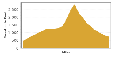
Kancamagus Scenic Byway cuts through the heart of the White Mountain National Forest and is the highest roadway in the northeast, peaking at 2,900 feet on Mount Kancamagus. Revel in spectacular views of mountains, valleys, waterfalls and wild and scenic rivers. The “Kanc” is renowned for its fall foliage — when the hillsides light up with yellow birches, purple beeches, red maples in contrast with green spruce and hemlock trees, drawing thousands of leaf-peepers who crave the vivid display. Named for Chief Kancamagus, “The Fearless One”, who was the last leader of the Passaconaway Tribe in the late 1600s, the byway is also rich in Native American Indian history. Add in rustic covered bridges, waterfalls, recreation and the country charm of New England and you have the perfect adventure.
This scenic drive begins in Conway, known for its historic buildings, cozy inns and shopping in quaint local shops and outlet stores and heads west to Lincoln. It can be done in either direction, and makes a great companion to the White Mountain Trail. Note that parking, trailheads and some day-use activities along this road require a White Mountain National Forest Pass. And be sure to have a full tank of gas. Maintaining the pristine forest means that towns lie of either side of this drive. There are no services at all along this stretch of Kancamagus.
Just before heading out, stop at the Saco Ranger District (I1) for more information on walking, hiking and biking trails or in winter for cross-country-skiing, snow-shoeing and snowmobiling. There are hundreds of trails along this drive each offering its own glimpse into the natural beauty of the region. Keep an eye out for moose, deer, fox, black bear and almost 200 species of birds, including the green heron.
Heading west, the Kancamagus Highway follows the curves of Swift River through the Saco River Valley and you will soon arrive at the Albany Covered Bridge (B1). This paddleford truss with arches style bridge was built in 1858, replacing a bridge built a year earlier that was destroyed in a windstorm. Explore this picture-worthy bridge by taking the path from the parking area. Great photos can also be had from the north side of the river. Leaving from the Covered Bridge Campground is the very popular Boulder Loop Trail (H1). The 3.1-mile loop divulges evidence of glaciers from the last Ice Age dragging across the granite. The trail passes it namesake — huge boulders and 18 interpretive signs along the path reveal the geology, history and culture of the region. Standing 1000-feet above the Passaconaway Valley, you will be rewarded with amazing views of Mount Passaconaway, Mount Chocorua, and Mount Middle Sister. Take caution and stay back from the fragile cliff ledges. When you get down, cool your toes in Swift River.
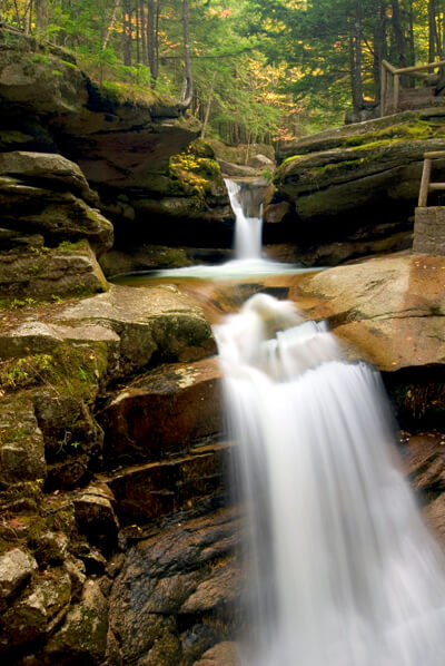
Champney Falls Trail (H11) is an easy 3.6-mile round trip on a logging road, through dense forest. At 1.4-miles take the spur loop trail which passes the beautiful Champney Falls and Pitcher Falls. Spring is best for impressive water flows as it tends to dry up by summer. In winter, you can watch climbers scale the frozen icy chutes — or if you’re experienced, climb it yourself. Trailhead begins at Champney Falls parking area.
This region is chock full of swimming holes and Lower Falls Swimming Hole (W2) is one of the best. Surrounded by dense lush forest, the beautiful cascade and the still pools make a refreshing spot to swim or lounge on the surrounding rocky outcrops. It is a full-service area with changing rooms, restrooms and picnic tables — which also means it can be busy on hot summer days. Arrive early if you plan on spending the day here.
Explore the dramatic Rocky Gorge Scenic Area (H2). The glacier-formed Rocky Gorge and Lower Falls is a short walk from the parking area. The nearby Lovequist Loop Trail (H10) is an easy walk, less than 1-mile around Falls Pond, crossing the foot bridge over Rocky Gorge.
In three miles, Bear Notch Road (T1) is on the right (north) side of the road. Connecting the Kancamagus Highway and the White Mountain Trail (NH-302), this is a great ride, with a lot of twisty curves and fabulous scenery through the resplendent White Mountain National Forest. Take it as a scenic side trip to Bartlett and retrace the road to come back. The road is closed in winter, except for the first mile to access the Upper Nanamocomuck Trail, a popular 9-mile trail for cross-country skiing. The Lower Nanamocomuck Trail is 7-miles long and heads from Bear Notch Road to the Albany Covered Bridge. Both are known as four-season ski, run, bike trails. While in Bartlett, consider a few other nearby scenic detours, including the White Mountain Trail. Bear Notch Road is also home to the 2,600-acre Bartlett Experimental Forest which studies northern hardwood forests. You will also find great mountain biking trails here.
Back on Kancamagus, in a mile, you arrive at the Russell-Colbath House (A1). Built in 1832, it is said that one day in 1891, Mr. Colbath went out, telling his wife that he would return soon. His wife hung a lantern outside each night to help him find his way, and 39 years later, he did return, his wife having died three years earlier. The 19th-century farmhouse with period furnishings is open to visitors and features an on-site historic interpreter and programs that explores the life of a homesteader and the history of the Passaconaway Valley. Beside the house, is an old cemetery with tombstones dating back to the Civil War. Learn more about the forest, railroad and Swift River on the short, accessible half-mile Rail N’ River Trail.
A few miles west, is Sabbaday Falls (H3) one of the most visited falls in New Hampshire. The strikingly beautiful three-tiered flume can be accessed by a short half-mile trail from the parking area where you will also find picnic tables. No swimming is allowed, but if you continue on the lush, mossy Sabbaday Brook Trail, those with a license can fish in Sabbaday Brook.
The road ascends, until arriving at Kancamagus Pass. Stop at the pullout to enjoy a panorama of the surrounding forest and to learn about the watersheds east of the Kancamagus Pass flowing into the Saco River and those west flowing into the Pemigewasset River.
Hancock Campground is among many first-come, first-serve campgrounds. It’s a short walk from there to another swimming hole, Upper Lady’s Bath Swimming Hole (W3) to enjoy the cool Pemigewasset River.
The 5.6-mile round trip Lincoln Woods Trail (H5) is popular year-round and begins by crossing the 180-foot long Pemigewasset River Suspension Bridge. Many other trails leave from here and you can get more information about the myriad of recreation opportunities at the nearby White Mountain Visitor Center (I2). The visitor center features an interpretive display on the history and evolution of White Mountain Forest.
Back on Kancamagus, don’t miss the Sugar Hill Scenic Overlook or the C. L. Graham Wangan Ground Picnic Area (H4), which affords one of the best views of the Presidential Range. The road descends with twists and turns from Kancamagus Pass, following the Permigewasset River as you pass the final few mountains.
Our scenic drive comes to an end as you arrive in Lincoln. From here, consider exploring the White Mountain Trail.

Other Nearby Places of Interests
Cannon Mountain Aerial Tramway (A2): The Cannon Mountain Aerial Tramway is an 80-passenger cable car that brings you to the 4,100 foot summit of Cannon Mountain, offering incredible 360 degree panoramic views into Vermont, Maine, and Canada. There is a fee to ride up. In winter, Cannon Mountain is among the top ski resorts in the region. While here, visit the Old Man Museum at the base of Cannon Mountain which immortalizes the much-beloved stone profile or the New England Ski Museum featuring items related to the history of skiing since 1977 such as ski equipment, scrapbooks, films and library.
Bartlett Covered Bridge (B2): Built in 1851, it was abandoned and closed to traffic in 1939. In 1966, the bridge was repaired and opened as the Covered Bridge Shoppe featuring gifts and antiques.
Echo Lake State Park (H6): Visit Echo Lake State Park and its jewel, Cathedral Ledge, a 700-foot high rock formation. For the adventurous, it is a rock climber’s utopia. For others, it is a stunning backdrop as you watch. A mile-long auto drive brings you the easy way to the top for exhilarating panoramic views of the Saco River Valley and the White Mountains. Up for a hike? Try the 1-mile Around the Lake Trail, the 1.2-mile Bryce Path to the top of Cathedral or the 4.2 mile White Horse Ledge Loop. Enjoy swimming, boating, fishing, and biking. There is a fee to enter the park and NH residents over 65 and children under 5 are free.
The Flume Gorge (H7): Sitting at the foot of Mount Liberty is the incredible glacier-formed Flume Gorge. Start at the Visitor Center for entrance tickets to the gorge and learn about the area through interactive displays, interpretive programs and a 20 minute film presentation. (Except for access to the Flume Gorge, or other attractions, there is no charge to travel through Franconia Notch State Park.) The Flume is a natural gorge 800 feet long with granite walls looming more than 80 feet. To the loud sound of rushing water, get close up on the wooden bridge that travels along the flume. You’ll want to explore the few hiking trails that traverse the lush, mossy environment. Once through the gorge don’t miss the two trails on your passing glacial boulders, small waterfalls and majestic trees or the impressive Avalanche Falls. Continuing the hike is a delight for all senses with the sounds of birds chirping, the Pemigewasset River, glacial boulders and other wonders such as Liberty Gorge, a mountain cascade through narrow rock. Look for Liberty Gorge Trail is just off Ridge Path to get there. Spanning the “The Pool” is Sentinel Pine Bridge. This covered bridge was built in 1939 over a giant pine tree thought to be 100 years old that fell during a hurricane. If you get a chance to look underneath, you will see the trunk.
The Basin (H8): The Basin is a smooth water-sculpted granite basin at the base of a waterfall. There are picnic tables and you can swim further up in the brook. If you love waterfalls you should follow the Basin-Cascades Trail which passes the 20-foot drop of Kinsman Falls, the multi-tiered Rocky Glen Falls and many unnamed cascades. The mile long trail features rock slides, pools and ledges are fun to swim in. Here you can also see Baby Flume Falls.
Crawford Notch State Park (H9): Over 5,700 acres of hiking, fishing, wildlife viewing and mountain views await as well as the second highest falls in New Hampshire, Arethusa Falls. Have your camera ready for this incredibly elegant cascade. The hike is somewhat difficult in places due to loose rocks, mud and steep areas but very much worth the effort. It also passes Fawn Pool, Coliseum Falls and Bernis Brook Falls and the sheer rock walls of Frankenstein Cliff.
Old Man of the Mountain Overlook (V1): The Old Man of the Mountain Overlook now gazes upon the broken ledge where until May 3, 2003, the prominent profile once stood. Naturally-formed from five separate granite ledges, the profile was an icon and appears on license plates, state quarters and state route signage.
Echo Lake (W1): Echo Lake is a spring-fed lake at the foot of Cannon Mountain and is a popular location for fishing and boating. Explore the surrounding forests for the best experience. There is a fee to access the beach.
Share
 | ||||||
| Sun | Mon | Tue | Wed | Thu | Fri | Sat |
|---|---|---|---|---|---|---|
Send this link to your phone. Standard text messaging rates apply.
() -