

Three Rivers Scenic Drive
Following the Ellis, Peabody, and Androscoggin Rivers
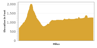
| Mileage | 67 miles (108 km) |
|---|---|
| DurationThe duration is an estimate of a one-way drive and does not include any stops or side-trips. | 1 hour, 37 minutes |
| SeasonsThe seasons listed are the best seasons for this scenic drive. If Winter is not mentioned, the road may be closed during the winter. | All Seasons |
| Roadways | New Hampshire Highway 16 |
| PassesSome of the adventures on this scenic drive require an admission fee that these passes cover. Please read the drive description for more information. | White Mountain National Forest Passes (New Hampshire) |
| ServicesThe cities or towns listed have either Food or Services such as gas, pharmacies, etc. | Glen, NH▼, Conway, NH▼, Jackson, NH▼, Gorham, NH▼, Berlin, NH▼, Shelburne, NH▼, and Dixville Notch, NH▼ |
| Rating | 3.5 average from 37 votes |
| My DrivesTrack your favorite scenic drives by selecting those which you want to take and those that you have taken. Using your free account, simply sign in and select My Drives. | |
| Share |

Our free Road Trip Planner will reverse the route and include the places of interests. Click the “Add to Road Trip” above to start planning your next road trip.
Send this link to your phone. Standard text messaging rates apply.
() -Get directions from your start address to the beginning of and including this scenic drive. Choose either an alternate ending or same as start.
Have more destinations? Use our free Road Trip Planner to completely plan your adventure. Click the “Add to Road Trip” above to start planning your next road trip.
Get a Park Pass
Natural areas along this route require an entrance fee used to protect and maintain our most scenic treasures. Save time by purchasing your forest passes before you go.
White Mountain National Forest is home to 48 peaks over 4,000 feet, topped by Mount Washington, the highest mountain in the northeast and an iconic drive to its stately summit. Discover the sublime beauty of Pinkham Notch, waterfalls, rivers and lakes in a region synonymous with recreation.
Our drive begins in Glen and travels to Wentworth Location, but can be done in either direction. To reach Glen, we recommend using either the Kancamagus Scenic Byway or the White Mountain Trail, both of which start at I-93.
The first half of this scenic drive travels through the White Mountain National Forest. Note that parking, trailheads and some day-use activities along this road require a White Mountain National Forest Pass.
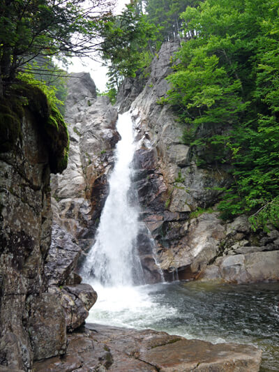
Heading north on NH-16, the road parallels the Ellis River and in Jackson, you enter the White Mountain National Forest. Stop to take in the breathtaking views of the Ellis River Valley. In a few miles, don’t miss the powerful chute of the 64-foot Glen Ellis Falls (H1). Follow the 0.3-mile easy trail from the parking area which leads through a tunnel under the highway. There is a viewing platform at the top and midway, as well as 150 stone steps down to the glistening green pool at the bottom. New Hampshire is adorned with many spectacular waterfalls and two more come up later in the drive.
Continuing north on NH-16, you soon arrive at the mountain pass Pinkham Notch (H2), named after Daniel Pinkham who explored this area in the 1700s on a sled pulled by a pig. Carved by glaciers, erosion and rivers, Pinkham Notch separates the Presidential, Wildcat and Carter-Moriah Ranges, creating a stunning landscape. Marvel at picture-perfect snow-dusted peaks and expansive views. Stop at the Pinkham Notch Visitor Center located at the top of the Notch just south of Wildcat Ski Area which serves as a hiker hostel and restaurant as well. Many trails leave from here year-round including the Tuckerman Ravine Trail, which travels by Tuckerman Ravine, a glacial cirque left behind during the last ice-age and is the most popular route to the summit of the 6288-foot Mount Washington. An easier way to those incredible views can be had by taking the 1-mile, round trip, Square Ledge Trail. Be careful, the aptly named trail has steep drop-offs. Lost Pond Trail is another short walk to exquisite views of the reflecting mountains on Lost Pond and beaver dams. Or hike to Crystal Cascade a dazzling, two-tiered waterfall, both elegant and strong as tumbles through lush forest. The falls are about 3/10 of a mile up Tuckermans Ravine Trail.
Back on the road, shortly after Pinkham Notch, the Ellis River ends and the Peabody River parallels the road.
The Wildcat Mountain Ski Area (A1) is New Hampshire’s premier ski destination but offers much to do year-round. Take the gondola to Wildcat’s 4,100-foot summit and once at the top, enjoy a picnic and explore the stunted boreal Spruce/Fir forest, wildflowers and wildlife. There is a charge to ride the gondola but Wildcat Mountain also features many free Summer Naturalist Programs. Thompson Falls (H11) drape dramatically across a wide rocky outcrop, and tumble again lower down, where you can scramble among the rocks and enjoy the cool water. It is an easy hike beginning near the base lodge at Wildcat Mountain Ski Area.
The Mount Washington Auto Road (T1) is the highlight of this drive. Beginning at The Glen House just ahead, the Mount Washington Auto Road spirals 8-miles up to the top of Mount Washington, one of the most accessible mountain summits in the United States. The road was completed in 1861 and the 12-degree grade was an engineering marvel. There is a charge to drive up which includes an audio tour (on CD or cassette) and the infamous “This Car Climbed Mt. Washington” bumper sticker. Should your vehicle not be in tip-top shape, you may want to consider a guided shuttle tour. Either way, it’s quite a ride. Magnificent views of mountain, valley, forest, and rocky precipices await as the road hugs the mountainside — with nary a guard rail in sight. Elevation changes mean climate changes and with that you are rewarded with diverse flora and fauna from lush forest to alpine flowers clinging in the thin soil above the treeline. Culminating with panoramic views that span into New York, Vermont, Maine, into Canada, and the Atlantic Ocean, this is truly an adventure. In winter, SnowCoach tours are available in a van converted with track system instead of wheels. For those undertaking long hikes, there is a shuttle service from AMC Pinkham Notch, the Great Gulf Trailhead and one-way for hiking down Mount Washington.
About a mile past the Mount Washington Auto Road is the Great Gulf Overlook (V1), where you can see a glacier cirque surrounded by the vast rugged wilderness. A glacier cirque is a bowl-like depression carved in a mountain by a glacier, this one having long since melted.
As you exit the White Mountain National Forest, visit the Androscoggin Ranger District (I1) for regional information. The historic small town of Gorham makes a great base for recreational activities and features a variety of dining, shopping and outfitters.
The Peabody River merges with the Androscoggin River which the NH-16 follows for the remainder of this scenic drive. Consider a small side-trip east on US-2 for 3-miles to North Road (T2). Especially during the fall foliage, this road is a treat, meandering around the Androscoggin River, passing peaceful country-side, farms and stables. North Road runs from US-2 near Gorham and heads to Bethel, Maine, but you can turn right onto Meadow Road for a shorter trip, which also skips the portion of the road that is unpaved. Don’t forget to stop and gaze upon the Presidential Range to the west near the start of the road in Gorham.
Or take a side trip to Moose Brook State Park (H3) in the heart of the Presidential Range. Enjoy the array of recreation opportunities, including swimming, fishing, great hiking and biking trails, picnicking and camping. You may spot deer, but unfortunately, no moose. There is an entrance fee to this state park.
Heading north on NH-16, you soon arrive in the town of Berlin, where to the east of the town, you can see the Mahoouc Range. Popular for picnicking, fishing and boating is Nansan Wayside Park (H4) along the banks of the Androscoggin River. Note the 170-foot steel framed Nansen Ski Jump. Built in 1936 by Scandinavians who brought their love of winter sports, it was once the largest ski jump in North America. It is currently closed.
Just a few miles northwest of downtown Berlin is one of the newer additions to the New Hampshire state park system. Along with swimming, fishing, canoeing, kayaking, Jericho Mountain State Park (H12) is a destination for ATV, UTV, trail bike and snowmobile enthusiasts with miles of trails.
NH-16 then enters the Thirteen-Mile Woods Scenic Area where moose, deer, and bear enjoy the lazy and wild sections of the Androscoggin River. Take advantage of the many parks on the way. Androscoggin Wayside Park (H13) offers peaceful views and is popular with anglers, kayakers and canoeists as is Milan Hill State Park (H5). Milan Hill State Park also offers tent camping and yurts and in winter, a range of cross-country ski trails. In several miles, you arrive in the town of Pontook, home to the Pontook Reservoir Recreation Area (H6). An important bird area, have binoculars handy to observe the endangered or threatened Osprey, Common Loon, Pied-Billed Grebe, Bald Eagle and Northern Harrier, as well as a host of other waterfowl.
Continuing north following the Androscoggin River, you arrive in the mining town of Errol. If you were to head west on US-26 for 16 miles, you would reach the town of Dixville Notch, known as being one of the first cities to report national election results, though for this drive, we continue north on NH-16.
The scenic drive comes to an end as you arrive in Wentworth Location close to the Maine Border. While here, visit Lake Umbagog National Wildlife Refuge (A2) where the forests, wetlands, lakes and rivers are home to a wide variety of birds, mammals, amphibians and fish. Only 1/3 of a mile — the accessible Magalloway River Trail and its observation platform are ideal for viewing moose, boreal birds and waterfowl. Or explore by canoe, kayak or rowboat for a unique vantage point. Fishing is permitted with valid New Hampshire or Maine fishing license. From here, consider heading east on NH-16 into Maine, and following ME-16 to the Rangeley Lakes Region.

Other Nearby Places of Interests
Mount Washington Cog Railway (A3): On July 3, 1869, a feat of engineering, logistics and sheer determination, the “Old Peppersass” became the first cog-driven train to climb Mount Washington. Today, experience the incredible views with efficient biodiesel locomotives or the classic steam engine. Take 302 to Bretton Woods, left onto Base Road until the Cog Base Station.
Crystal Cascade (H10): Crystal Cascade is a dazzling, two-tiered waterfall, both elegant and strong as tumbles through lush forest. The falls are about 3/10 of a mile up Tuckermans Ravine Trail.
Echo Lake State Park (H7): Visit Echo Lake State Park and its jewel, Cathedral Ledge, a 700-foot high rock formation. For the adventurous, it is a rock climber’s utopia. For others, it is a stunning backdrop as you watch. A mile-long auto drive brings you the easy way to the top for exhilarating panoramic views of the Saco River Valley and the White Mountains. Up for a hike? Try the 1-mile Around the Lake Trail, the 1.2-mile Bryce Path to the top of Cathedral or the 4.2 mile White Horse Ledge Loop. Enjoy swimming, boating, fishing, and biking. There is a fee to enter the park and NH residents over 65 and children under 5 are free.
Rocky Gorge Scenic Area (H8): The glacier-formed Rocky Gorge and Lower Falls is a short walk from the parking area. The nearby Lovequist Loop Trail is an easy walk, less than 1-mile around Falls Pond, crossing the foot bridge over Rocky Gorge.
Crawford Notch State Park (H9): Over 5,700 acres of hiking, fishing, wildlife viewing and mountain views await as well as the second highest falls in New Hampshire, Arethusa Falls. Have your camera ready for this incredibly elegant cascade. The hike is somewhat difficult in places due to loose rocks, mud and steep areas but very much worth the effort. It also passes Fawn Pool, Coliseum Falls and Bernis Brook Falls and the sheer rock walls of Frankenstein Cliff.
Share
 | ||||||
| Sun | Mon | Tue | Wed | Thu | Fri | Sat |
|---|---|---|---|---|---|---|
