

Talimena Scenic Drive
From Talihina to Mena
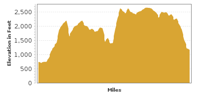
| Mileage | 60 miles (96 km) |
|---|---|
| DurationThe duration is an estimate of a one-way drive and does not include any stops or side-trips. | 1 hour, 21 minutes |
| SeasonsThe seasons listed are the best seasons for this scenic drive. If Winter is not mentioned, the road may be closed during the winter. | Spring, Summer, and Fall |
| Roadways | Arkansas Highway 88, and Oklahoma Highway 1 |
| ServicesThe cities or towns listed have either Food or Services such as gas, pharmacies, etc. | Mena, AR▼ |
| Rating | 3.9 average from 87 votes |
| My DrivesTrack your favorite scenic drives by selecting those which you want to take and those that you have taken. Using your free account, simply sign in and select My Drives. | |
| Share |

Our free Road Trip Planner will reverse the route and include the places of interests. Click the “Add to Road Trip” above to start planning your next road trip.
Send this link to your phone. Standard text messaging rates apply.
() -Get directions from your start address to the beginning of and including this scenic drive. Choose either an alternate ending or same as start.
Have more destinations? Use our free Road Trip Planner to completely plan your adventure. Click the “Add to Road Trip” above to start planning your next road trip.
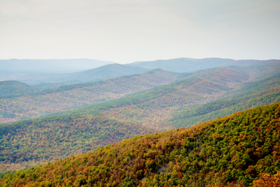
Talimena Scenic Drive is a roller coaster through the Ouachita National Forest, along the crest of Rich Mountain and Winding Stair Mountain. One of the first scenic byways designated by the US Forest Service in the 1960’s, it is well known for its curvy roads, fabulous breathtaking panoramas, and outdoor adventure opportunities.
The scenic byway’s name comes from the Frisco Railroad that ran between the towns of Talihina and Mena. The town of Talihina was named by the local Choctaws Native Americans meaning “iron road.” When Oklahoma became a state in 1906, they combined the Choctaw phrases for “red people” to form the word Oklahoma.
The scenic drive begins in the town of Talihina in Oklahoma and travels to Mena, Arkansas and is entirely within the boundaries of the 1.78 million acre Ouachita National Forest. You can reach Talihina by US-271 from the south, OK-1 from the west, or US-59 and US-271 from I-40. Make sure you have a full tank of gas as there are no gas stations along the scenic byway.
Notice that the Ouachita Mountains run east to west as opposed to most mountains which run north to south. This is due to continental plates crashing into North America some 200 million years ago which created the Ouachita Mountains. If you take the time to explore, you will notice that the plant life on the northern portion of the Ouachita Mountains is slightly different from its southern half.
Heading north on OK-1, the scenic drive enters dense forests of evergreens and pine. The rich soil is ideal for growing the pine forests, making this one of the leading sources of pine in the United States.
Shortly after entering the Ouachita National Forest, you arrive at the West End Visitor Center (I1). Stop in for information, trail guides and maps. Here US-271 continues north and OK-1 heads west towards Arkansas. For this scenic drive, turn right for OK-1 which marks the official start of the byway.
There are many hikes within the Ouachita National Forest including the Ouachita National Recreation Trail which heads approximately 200 miles to Little Rock, AK through some of the roughest and untamed terrains in this region as well as easier paths, near streams, forested mountains and a variety of elevations. Of course you do not need to hike the entire trail and there are many access points along the route.
Within a half of a mile, the Choctaw Vista (V1) is on your right. Take in the beauty of pristine nature looking east towards the majestic Mississippi and spectacular rolling hills. The overlook is named for the Choctaw Native Americans to remember the journey they took to comply with the Indian Removal Act of 1830, an act which “encouraged” tribes to move west promising the ability to live according to their traditions and maintain sovereignty.
The road continues east through a beautiful pine and oak forest. Along the way, there are many vista points offering panoramic views such as Potato Hills Vista overlooking the ancient geological formations of shale and chert, Holson Valley Vista and the particularly beautiful Panorama Vista (V4) with its view of Blue Mountain, Lake Wister, Holson Valley and more.
Next stop is Horsethief Spring (H2). Today, Horsethief Spring is a beautiful picnic spot with a nearby waterhole, but back in the 1800’s, this trail was a popular horse smuggling route where thieves camped overnight.
Shortly after Horsethief Springs, the Talimena Scenic Drive passes US-259 and curves towards the Robert S. Kerr Arboretum (A1), which is a perfect location to learn about the trees and ecology of the Ouachita National Forest through exhibits and short interpretative trails. Three trails explore the forests first-hand each with its own focus, Struggle for Survival, The Soil and You, and the Arboretum Trail. After the arboretum, watch for the miniature oak trees whose growth has been stunted by harsh winter conditions.
Continuing east for 14 miles, the scenic drive crosses into Arkansas and four miles later, you arrive at the Queen Wilhelmina State Park (H3). Swimming, canoeing, hiking, and extraordinary views await. Set atop 2,681-foot Rich Mountain, Arkansas’s second highest peak, Queen Wilhelmina Lodge is the focal point. Named after their queen, investors from Netherlands built a wonderful lodge here in the hope she would visit, but sadly that visit never occurred. Today the lodge is referred to as the “Castle in the Sky” and you can enjoy its spectacular panoramic vistas of Rich Mountain. A few hiking trails leave from the lodge. Take the 1.3-mile Lovers’ Leap Trail for its sweeping panorama of the Ouachita National Forest.
Next stop is Rich Mountain Tower. The tower is open for tours on weekends and views from the approximately 2,681 feet roost are unparalleled. The tower was originally constructed for spotting fires, but today, the Forest Service uses helicopters.
The route continues with more pullouts of breathtaking views including the aptly named Grand View Vista (V6).
A few miles up the road is Earthquake Ridge (H4), a 6.8-mile loop trail along the forest with views of unusual rock formations, sandstone outcrops and hopefully glimpses of wildlife.
Continuing east, the scenic drive passes the East End Visitor Center (I2) and comes to an end when you arrive in the town of Mena. From here, consider heading north on US-59 and then east on US-270 to Hot Springs and enjoying the Scenic Arkansas Highway 7.

Other Nearby Places of Interests
Talimena State Park (H1): Talimena State Park marks the start of the Talimena Scenic Drive. The park offers hiking trails through diverse terrain, off-road vehicle use, picnic areas, and camping.
Rich Mountain Tower (V5): Rich Mountain Tower is open for tours on weekends and views from the approximately 2,681 feet roost are unparalleled. The tower was originally constructed for spotting fires, but today, the Forest Service uses helicopters.
Share
 | ||||||
| Sun | Mon | Tue | Wed | Thu | Fri | Sat |
|---|---|---|---|---|---|---|
Send this link to your phone. Standard text messaging rates apply.
() -