
Scenic Byway 12
Bryce Canyon and Capitol Reef National Parks
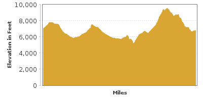
| Mileage | 123 miles (198 km) |
|---|---|
| DurationThe duration is an estimate of a one-way drive and does not include any stops or side-trips. | 2 hours, 30 minutes |
| SeasonsThe seasons listed are the best seasons for this scenic drive. If Winter is not mentioned, the road may be closed during the winter. | All Seasons |
| Roadways | Utah Highway 12 |
| PassesSome of the adventures on this scenic drive require an admission fee that these passes cover. Please read the drive description for more information. | America the Beautiful Resident Annual National Parks Pass 2026-2027 |
| ServicesThe cities or towns listed have either Food or Services such as gas, pharmacies, etc. | Panguitch, UT▼, Escalante, UT▼, Bryce Canyon, UT▼, Tropic, UT▼, Torrey, UT▼, Boulder, UT▼, and Bicknell, UT▼ |
| Rating | 4.1 average from 105 votes |
| My DrivesTrack your favorite scenic drives by selecting those which you want to take and those that you have taken. Using your free account, simply sign in and select My Drives. | |
| Share |

Our free Road Trip Planner will reverse the route and include the places of interests. Click the “Add to Road Trip” above to start planning your next road trip.
Send this link to your phone. Standard text messaging rates apply.
() -Get directions from your start address to the beginning of and including this scenic drive. Choose either an alternate ending or same as start.
Have more destinations? Use our free Road Trip Planner to completely plan your adventure. Click the “Add to Road Trip” above to start planning your next road trip.
Get a Park Pass
Natural areas along this route require an entrance fee used to protect and maintain our most scenic treasures. Save time by purchasing your forest passes before you go.
Stunning vistas will dazzle and amaze. Deftly depicting the sculpting skills of nature — using erosion, winds and water as tools, striking rock formations soar creating an alien silhouette against large open skies. Through Bryce Canyon to Capitol Reef National Park, this scenic drive has only been fully paved since 1985. The region is one of the last areas of the continental United States to be explored and named, enhancing the magic of the entire area.
Our scenic drive begins in the classic Old West town of Panguitch and heads to Torrey, where you can continue your adventure. A few miles south of downtown Panguitch on US-89 is where the Scenic Byway 12 begins.
Before departing, consider a side trip on Brian Head-Panguitch Lake Scenic Byway (T5) which heads west to enjoy the Panguitch Lake, summer wildflowers, colorful fall scenic drives, skiing at Brian Head during the winter, hairpins along the Braffit Ridge and Parowan Canyon, and the unforgettable views of the Cedar Breaks National Monument (A1).
Heading east on UT-12, you soon enter the Dixie National Forest and approach the Red Canyon, which has been meticulously carved and colored by nature. Not only is the canyon interesting to drive through, exploring its trails brings you to stunning views. The Red Canyon Visitor Center (I1) is a perfect location to learn about the trail network. The Bird’s Eye Trail and Pink Ledges Trail are under a mile long and both leave from the visitor center. Keep an eye out for East Fork Road (T8) on the right. An accessible gravel road brings you to astounding panoramic views in every direction. We recommend at least the first 30 miles of the road.
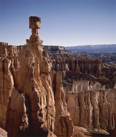
10 miles into the route, you arrive at the entrance to Bryce Canyon National Park (H2), which features 36,000-acres of rocks that change color and shape as the daylight dances across them. The canyon is actually not a canyon, but was rather carved from ice wedging into the rocks, forming the hoodoos.
The park has so much to offer and it all depends on how long you plan to spend in the park. If for nothing else, stop at the Bryce Canyon Visitor Center (I2) for the fabulous views, explore the park with one of the nearby hikes, and then take the scenic drive to Rainbow Point for northern views of the Park and the snaking rim of the Pink Cliffs. Take advantage of the many side-trips and pull-outs on your return back to UT-12. To explore the canyon’s floor, rent a horse or mule from the Bryce Canyon Lodge.
Back on UT-12, the drive enters Water Canyon. Here, a 1-mile round-trip hike brings you to Mossy Cave and to a waterfall within Water Canyon. The easy trail is great for kids and seniors who want to see the hoodoos up close without steep slopes. Not a natural canyon, Water Canyon was dug in the early 1890’s by Mormon pioneers to provide irrigation water for the nearby towns, thus changing the ecology of the area. Mossy Cave is actually a grotto created by an underground spring and its wet, moss covered walls make for a welcome respite from the dry desert heat.
As you approach Tropic, consider a side-trip on Cottonwood Canyon Road (T1). This 46-mile scenic route brings you to Kodachrome Basin State Park (H4), to formations such as Chimney Rock, Ballerina Slipper, and Grosvenor Arch, through the colorful Cottonwood Canyon, and then follows the Paria River sporting amazing views of the Cockscomb, where the Earth’s crust protrudes. Kodachrome Basin is believed to have been several million years ago very similar to what Yellowstone is today. Turn around and come back to UT-12 to continue this scenic drive.
Continuing east on UT-12, take advantage of the many pullouts to enjoy views such as the pink cliffs of Powell Point.
As you continue east, you will pass the town of Escalante, and shortly after, arrive at the Escalante Petrified Forest State Park (H5). The desert ambiance recalls its greener past with its forests of petrified trees. Hike the 1 mile Petrified Forest Trail which climbs 250 feet passing various petrified specimens or the 3/4 mile Trail of the Sleeping Rainbows. Stop in the visitor center to see Native American artifacts. The adjacent Wide Hollow Reservoir (W1) is an excellent location to enjoy birding, swimming, and fishing. In the town itself, consider a side trip on Smokey Mountain Road (T9), a gravel road that heads into the Kaiparowits Plateau. While you can do it in a car, we recommend a more rugged vehicle.
Continuing east, you pass Hole in the Rock Road (T6) heads to Devil’s Garden and then ends at the Hole-in-the-Rock, where pioneers created a hole with the Canyon Wall on the banks of Lake Powell within Glen Canyon National Park. Another great side trip for beautiful days is Hells Backbone Road (T7) which is gravel road that heads to the Box-Death Hollow Wilderness. The first 38-miles are spectacular and paved, but if you plan on driving through this wilderness, you should bring plenty of water and be prepared for all difficulties as the road is not patrolled frequently.
Heading east towards Boulder, the scenery is spectacular. Stop at the Calf Creek, where a 5.5-mile hike will bring you to the spectacular 126-foot Calf Creek Falls (H7).
Once in Boulder, consider a side trip on the Boulder-Bullfrog Scenic Road (T2) within Capitol Reef National Park (H1) on your way to Lake Powell and the Glen Canyon National Recreation Area. This 67-mile side-trip travels on partially dirt roads but the adventurous will surely profit. At the end of the road, either retrace back or head to the Bicentennial Highway.
No visit to Boulder would be complete without a stop at Anasazi Indian Village State Park (H6), which displays Anasazi Indian artifacts, including a partially excavated settlement and a museum.
From here, the drive climbs up Boulder Mountains, known for its beautiful fall scenic drives. Take advantage of the many scenic overlooks for expansive views of Capitol Reef, Henry Mountains, and Navajo Mountain.
The scenic drive ends as you arrive in Torrey, but your adventure does not need to end here. Capitol Reef National Park (H1) has numerous outcroppings caused by the folding in the Earth’s crust. The area is home to many petroglyphs depicting the Fremont Indians life in this area. The park is home to the Hickman Natural Bridge which is a sandstone bridge that spans 133-feet. For a beautiful side trip, we recommend Cathedral Valley Road (T3), a dirt road which meanders through the Capitol Reef National Park where you can enjoy the canyons and monolithic rocks spread across the desert. On the way through the valley, take advantage of the overlooks and many short hikes near the overlooks. At the end of the 60-mile road, you will be in Fremont Junction. Or for a paved side trip, enjoy Bicentennial Highway.

Other Nearby Places of Interests
Mossy Cave Trail (H3): Not a natural canyon, Water Canyon was dug in the early 1890’s by Mormon pioneers to provide irrigation water for the nearby towns, thus changing the ecology of the area. Mossy Cave is actually a grotto created by an underground spring and its wet, moss covered walls make for a welcome respite from the dry desert heat.
Daughters of Utah Pioneers Museum (M1): Visit the Daughters of Utah Pioneers Museum for a fascinating look into the life of early Pioneers via exhibits and artifacts.
Paunsaugunt Western Wildlife Museum (M2): The Paunsaugunt Western Wildlife Museum is one of the best wildlife museums in the West.
Fishlake Scenic Byway (T4): The Fishlake Scenic Byway climbs up to an elevation of 9,000 feet and heads into the Fishlake National Forest which surrounds the beautiful blue-green waters of Fish Lake. The area is popular with fisherman, bikers, and campers.
Share
 | ||||||
| Sun | Mon | Tue | Wed | Thu | Fri | Sat |
|---|---|---|---|---|---|---|
