Zion Canyon Loop
Around the Soaring Monoliths
| Mileage | 145 miles (233 km) |
|---|---|
| DurationThe duration is an estimate of a one-way drive and does not include any stops or side-trips. | 3 hours, 8 minutes |
| SeasonsThe seasons listed are the best seasons for this scenic drive. If Winter is not mentioned, the road may be closed during the winter. | Spring, Summer, and Fall |
| Roadways | Interstate 15, US Highway 89, and Utah Highways 14 and 9 |
| PassesSome of the adventures on this scenic drive require an admission fee that these passes cover. Please read the drive description for more information. | America the Beautiful Resident Annual National Parks Pass 2026-2027 |
| ServicesThe cities or towns listed have either Food or Services such as gas, pharmacies, etc. | Hurricane, UT▼, Mount Carmel, UT▼, Orderville, UT▼, Glendale, UT▼, Cedar City, UT▼, Brian Head, UT▼, Kanab, UT▼, Springdale, UT▼, more...and Mount Carmel Junction, UT▼ |
| Rating | 3.9 average from 106 votes |
| My DrivesTrack your favorite scenic drives by selecting those which you want to take and those that you have taken. Using your free account, simply sign in and select My Drives. | |
| Share |
Our free Road Trip Planner will reverse the route and include the places of interests. Click the “Add to Road Trip” above to start planning your next road trip.
Send this link to your phone. Standard text messaging rates apply.
() -Get directions from your start address to the beginning of and including this scenic drive. Choose either an alternate ending or same as start.
Have more destinations? Use our free Road Trip Planner to completely plan your adventure. Click the “Add to Road Trip” above to start planning your next road trip.

Get a Park Pass
Natural areas along this route require an entrance fee used to protect and maintain our most scenic treasures. Save time by purchasing your forest passes before you go.
Some of Utah’s most amazing scenery lies along the Zion Canyon, where sun-kissed sandstone cliffs and soaring monoliths reach for the sky, constantly changing color. A feast for the eyes, jagged stone, prickly sagebrush, carved and cracked canyons, water both rough and serene, combine to create an unimaginable majestic beauty.

The scenic drive begins in the outskirts of Hurricane, which you can reach from exit 16 from I-15 for UT-9. On the way to Hurricane, you will pass Quail Creek State Park (H1), where you can enjoy a picnic, camping, boating, or fishing.
Heading east on UT-9, the road begins to climb, following the Virgin River and the Pine Valley Mountains dominate the views. Arriving in Virgin, consider a side-trip up Kolob Road (T1). While portions of this road are unpaved and closed during the winter or rain, Kolob Terrace Road brings you to the western portion of Zion National Park, offering stunning views of the multi-colored layered mesas and bluffs of Tabernacle Dome and Guardian Angels. As a special bonus, this area is typically less crowded. The viewpoint makes a great picnic spot.
As you continue east on UT-9, you will pass the Gooseberry Mesa, Smithsonian Butte, and the Eagle Crags as you approach the town of Spingdale. For a closer look at these buttes, we recommend a side-trip on Zion and Smithsonian Butte Road (T3). In the town of Rockville, head south on Bridge Road and then turn right onto 250 S Road until you reach the well maintained dirt road to Wire Mesa summit, where you can see the 6,632 foot high Smithsonian Butte and the Zion formations. To fully enjoy the views, head south for a bit until Big Plain Junction, where you can then turn around and enjoy the views all over again on your way to Zion National Park. While you are here, continue to Grafton (A1), a popular town in the 1950s but after droughts, floods, and various confrontations, it eventually became a ghost town by the 1900s. Today it is frequented by visitors and film crews. You can reach it by turning right onto the unpaved Grafton Road.
Just past Springdale lies the entrance to Zion National Park, where we recommend a scenic drive up Zion Canyon Road (T2). Meticulously carved by the Virgin River and surrounded by amazing rock formations and dinosaur tracks, the 6-mile trip to the center of the Zion Canyon is filled with awe and inspiration. A landscape with amazing variety, stop at the turnouts for views, photographs and hiking adventures, such as Emerald Pools Trail (H2), an easy hike which features waterfalls spilling over canyon ledges into the three-tiered Emerald Pools, or the short Grotto Trail from the Grotto Picnic Area (H3). Many hikes begin or end at the picnic area including the thrilling and challenging Angels Landing which brings you up 22 switchbacks, via narrow rock fins and dizzying drop-offs to a spectacular view of the canyons, assuming, that is, you like heights. The 7-mile Zion Canyon Road ends with a the Riverside Walk, a 2-mile round trip walk through the canyon walls, to experience wildflowers, tree frogs, and several species of birds. The park has a number of guided hikes from March to November.
Back at UT-9, the scenic drive heads up Mount Carmel and then goes through the Zion-Mount Carmel Tunnel. Built in the 1930s, the 5,613-foot long tunnel is carved out of the solid mountain and was the longest tunnel road in the United States when it was built.
After the tunnel, keep an eye out for the Canyon Overlook Trail (H5). The short, .5-mile trail brings you to the overlook of the Pine Creek and Zion Canyon.
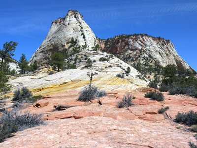
The incredible scenery continues as you head east on UT-9. This section includes interesting patterns naturally carved into the mountains, such as those at Checkerboard Mesa (H6). The Navajo sandstone has been weathered in such a way that it looks like a checkerboard pattern.
When you arrive at Mount Carmel Junction, UT-9 comes to an end. At the US-89 intersection, this scenic drive heads north. However, we recommend that you make a detour to Coral Pink Sand Dunes State Park (H7). Undulating ribbons of pink sand streak the dunes. Kids and adults alike will feel compelled to dig into this giant sandbox. To reach it, head south on US-89, and turn right on Sand Dunes Road. The area is also popular with ATVs.
Heading north on US-89, you will drive through orchards and farms as you pass Mount Carmel and Glendale, with beautiful plateaus and deserts in the distance. In Long Valley Junction, turn left onto UT-14 which will bring you deeper into the Dixie National Forest.
In 8-miles, take a side-trip on Strawberry Point Road (T4), which offers an amazing panoramic view of Zion National Park from the northeast corner of the park.
In 8-miles, Navajo Lake (W1) will be on your left. The small lake was formed by a volcanic eruption and today feeds into the Great Basin and Colorado River with its underwater sink holes which can sometimes be seen on the east side of the lake. Stop at the lake for a picnic, boating or excellent trout fishing.
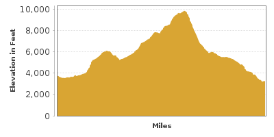
Head west on UT-14, you arrive at Cedar Breaks National Monument (A2) in 7-miles. Created by millions of years of sedimentation, uplift and erosion the giant amphitheater sits at 10,000 feet of elevation, 2,000 feet deep, spanning 3 miles, and unforgettable views of blazing colors as the sun dances across the formations. The five mile scenic drive passes the Monument’s main attractions including the four overlooks, all highly recommended stops as each one displays a unique perspective of the canyons below. While on UT-148, consider a side trip on Brian Head-Panguitch Lake Scenic Byway (T6) which to the east you can enjoy Panguitch Lake, it’s summer wildflowers and fall foliage drives and continue on Scenic Byway 12 or to the west for hairpins turns along the Braffit Ridge and Parowan Canyon or skiing at Brian Head during winter.
Continuing west on UT-14, keep an eye to the south for Kolob Terrace, the towers of Zion, beautiful cliffs, and ancient lava outcroppings in the distance. Soon you will arrive at Kolob Road (T1) which can be used as a back country route through Zion National Park to bring you back to Virgin, but our scenic drive continues west.
When you arrive in Cedar City, this scenic route heads south on I-15 back towards Hurricane. However, before reaching Hurricane, take exit 40 for Kolob Canyons Road (T5). The 5-mile road offers a chance to see a quieter side of the Zion National Park without many tourists. Take advantage of the pullouts and interpretive roadside exhibits to learn about the geological history of the Navajo sandstone canyons and perhaps catch a glimpse of the wildlife that makes its home here including ravens, lizards, snakes, jackrabbits and mountain lions. There are a variety of hikes for every level — the easy 1 mile round trip Timber Creek Trail from the picnic area or the 14.4 mile strenuous hike to the world’s largest free-standing arch, Kolob Arch. The hike is not recommended in July and August when temperatures can reach over 100 degrees and all hikes long or short should include water, maps, sunhats and sunscreen.
Back on I-15, this scenic drive comes to an end as you approach Hurricane, however, consider heading south all the way to St. George and exploring Snow Canyon State Park (H8). Black and white layers of lava rock, red sandstone, colorful desert plants, petroglyphs and volcanic remnants that shaped the canyon combine to create a landscape of undeniable beauty. Hikes of all levels offer a chance to see the wonders up close. The Hidden Piñon Trail is a 1.5 mile self-guided hike that meanders through lava rocks, canyons, flatlands and spectacular views. The 2-mile Butterfly Trail travels to the park’s lava tubes and offers options to differ the length or challenge of this hike with alternate routes. No visit to the park is complete without a stop at Panorama Point. To reach the park from St. George, head north on UT-18. For a short scenic loop, head south on UT-300, and then come back towards St. George.
Other Nearby Places of Interests
Riverside Walk (H4): The Riverside Walk is a 2-mile round-trip hike through the canyon walls of Zion National Park. The walk is a great chance to see the natural wildlife within the park, which includes tree frogs and many bird species. The park has a number of guided hikes from March to November.
Daughters of Utah Pioneers Museum - Orderville (M1)


