
Wisconsin Lake Superior Byway
Skirt the shores of the largest freshwater lake
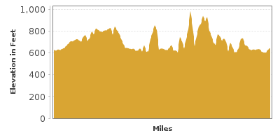
| Mileage | 103 miles (167 km) |
|---|---|
| DurationThe duration is an estimate of a one-way drive and does not include any stops or side-trips. | 2 hours, 7 minutes |
| SeasonsThe seasons listed are the best seasons for this scenic drive. If Winter is not mentioned, the road may be closed during the winter. | All Seasons |
| Roadways | US Highways 2 and 53, and Wisconsin Highway 13 |
| PassesSome of the adventures on this scenic drive require an admission fee that these passes cover. Please read the drive description for more information. | America the Beautiful Resident Annual National Parks Pass 2026-2027 |
| ServicesThe cities or towns listed have either Food or Services such as gas, pharmacies, etc. | Duluth, MN▼, Superior, WI▼, Washburn, WI▼, Hermantown, MN▼, Proctor, MN▼, Saunders, WI▼, Bayfield, WI▼, Superior Village, WI▼, more...and Ashland, WI▼ |
| Rating | 2.9 average from 58 votes |
| My DrivesTrack your favorite scenic drives by selecting those which you want to take and those that you have taken. Using your free account, simply sign in and select My Drives. | |
| Share |

Our free Road Trip Planner will reverse the route and include the places of interests. Click the “Add to Road Trip” above to start planning your next road trip.
Send this link to your phone. Standard text messaging rates apply.
() -Get directions from your start address to the beginning of and including this scenic drive. Choose either an alternate ending or same as start.
Have more destinations? Use our free Road Trip Planner to completely plan your adventure. Click the “Add to Road Trip” above to start planning your next road trip.
Get a Park Pass
Natural areas along this route require an entrance fee used to protect and maintain our most scenic treasures. Save time by purchasing your forest passes before you go.
Explore the shores of Lake Superior, the largest freshwater lake in the world, the astounding beauty of Apostle Islands National Lakeshore, and small towns brimming with appeal. Revel in superior views (sorry we couldn’t resist) with a bounty of recreational opportunities, historic and cultural sites.
We describe the drive traveling from the westernmost corner of Lake Superior near the border of Minnesota in the town of Superior to Ashland, but of course it can be done in either direction.
If you are coming from Minnesota, don’t miss the Lake Superior Maritime Visitor Center (W1) at Canal Park in Duluth. View fascinating exhibits, artifacts, and models reflecting the history and importance of Lake Superior, then watch huge ships as they travel through the canal. Admission is free.
If time allows, before beginning the drive we recommend a side trip to the highest waterfall in Wisconsin at Pattison State Park (H2). More than 9-miles of hiking trails explore unique basalt lava flows, the 165-foot Big Manitou Falls, and Little Manitou Falls. Discover the plants and animals that thrive in the boreal forest along Beaver Slide Nature Trail. There is a swimming beach on Interfalls Lake and camping for tents and RV’s. At the Gitche Gumee Nature Center, learn more about the area history, geology and wildlife. There is an entrance fee for most Wisconsin State Parks which can be paid on-site, or consider an annual sticker.
From Superior head east on WI-13. The 3.5-mile Wisconsin Point is the largest freshwater sand spit in Wisconsin, and an important rest stop for migratory birds. Walk or drive to the end to explore a Chippewa burial site and the Wisconsin Point Light House (A1).
From WI-13, take Country Rd U South to Amnicon Falls State Park (H1). Short hiking trails wind around the Amnicon River, and to four waterfalls. Spring snow melt provides the most powerful water flows, but beautiful pine forest and interesting rocky outcrops make this a wonderful year-round destination. Don’t miss the picture perfect 55-foot Horton Covered Bridge originally built in 1934. Enjoy wildlife and bird watching, swimming, fishing, rustic camping, and participate in a myriad of park education programs.
Along the byway are many state natural areas. Most have limited services, but if you enjoy unique natural habitats and observing wildlife, they are well worth a visit. One of the more developed and largest is the Boreal Forest State Natural Area (H4). Running through the center is the 44-mile long Bois Brule River. The river is a popular destination for canoeing and kayaking, offering an easy paddle in calm waters, or in some sections, the thrill of whitewater with class II and III rapids. (Rentals with shuttle service can be found at outfitters in Brule). Or join the legacy of five U.S. presidents — Ulysses Grant, Grover Cleveland, Calvin Coolidge, Herbert Hoover, and Dwight Eisenhower, who have spent summers here fishing for brown trout, steelhead and chinook salmon. Hike the 1.7-mile loop Stoney Hill Nature Trail for breathtaking views, or if your up for a longer hike, a 16-mile section of the North Country Trail passes through here. The North Country Trail stretches from Crown Point in eastern New York to Lake Sakakawea State Park in central North Dakota, and once complete, will be the longest continuous hiking trail in the U.S. There are two camping options, Bois Brule Campground and Copper Range Campground, both of which do not have electric sites.
Here the road skirts the coastline with views of Lake Superior. Take your time while driving and keep an eye out for motorcycles and cyclists.
With a population of less than 500 people, Port Wing is a small, quaint working commercial fishing village. Watch the boats, then peruse shops and galleries housed in converted fishing sheds. Swim or just relax amid sparkling vistas on the 20- mile sandy beach. At nearby Port Wing Boreal Forest State Natural Area (H4), explore diverse habitats: dry boreal forest, sand spits, dunes, wetlands, swamps and bogs, home to pitcher plants and the flutter of the rare black meadowhawk dragonfly and bog copper butterfly.
In Herbster, detour from the byway along Bark Bay Point Road for sensational lake views at Bark Point. Bark Bay Slough State Natural Area (H5) is an important birding area, watch for red-throated loons, bald eagles, and American bitterns.
The byway continues to Cornucopia, the gateway village to the Apostle Islands. Also known as the sailing capitol of Wisconsin, enjoy a plethora of water-based recreation, dine on fresh-caught fish, stroll the downtown shops, and find a range of accommodations. There are two nearby waterfalls: Siskiwit Falls (H7) or take the beautiful 2-mile hike to Lost Creek Falls (H6), bonus is you can walk behind this cascade.
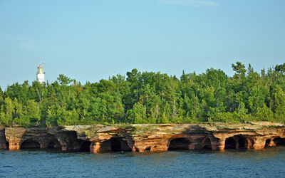
The focal point of this drive are the extraordinary Apostle Islands. The Apostle Islands National Lakeshore (W2) comprise 21 islands and a 12-mile section on the mainland. At the Apostle Islands Maritime Cliffs State Natural Area (H8), walk along Lakeshore Trail near Meyers Beach for views of the Sea Caves at Mawikwe Bay. Waves, wind, heat, ice, and time have sculpted dramatic vaulted chambers, arches, and pillars into the sandstone cliffs. In the distance you can see Eagle Island, Sand Island, and York Island. But the best vantage points are by boat, so make sure you have planned a minimum of a half-day for exploring and a few days if possible. The Little Sand Bay Visitor Center (I1) offers information on the region and details on visiting the islands. If you’re traveling in the opposite direction, stop at the Bayfield Visitor Center and Park Headquarters (I2) in Bayfield.
If you have your own canoe or kayak, you can use the boat launch at Meyers Beach. In the surrounding towns of the Bayfield Peninsula are outfitters offering boat rentals, guided tours, fishing and sailing charters, ferry and water taxis. The National Park Service features a variety of narrated tours and shuttle services which depart from Bayfield through Apostle Islands Cruises, a NPS authorized concessionaire.
Each island is unique and offers interesting activities whether you’re into hiking, paddling, scuba diving, camping, or just taking in the breathtaking views. A small sampling: Stockton Island is known for sandy beaches such as Julian Bay, and visitor center; Oak Island is home to Hole-in-the-Wall sea arch; and Basswood Island reveals its historic past quarrying the sandstone used in brownstone buildings, and through remnants of logging and farming. Throughout the islands are 8 lighthouses. Sand Island Lighthouse, Michigan Island Lighthouse and Raspberry Island Lighthouse are open for tours. La Pointe Lighthouse and Outer Island Lighthouse are closed to the public but are interesting to see and photograph. Camping is available on 18 of the Lakeshore’s 21 islands — note a camping permit is required from NPS prior to heading out. In winter, if Lake Superior freezes to a safe depth, the sea caves are accessible by foot and open to the public. If the opportunity arises, do not miss the wondrous display of ice-draped rock formations. Check the Apostle Islands website for the winter schedule. There is a fee to enter the Apostle Islands covered by an America the Beautiful Pass.
Little Sand Bay Campground (C1) is on the mainland of the Apostle Islands National Lakeshore. It features RV, trailer, tent and group sites. The surrounding habitat is nesting area for more than 150 bird species including the Piping Plover, and a rest stop for more than 250 bird species during spring and fall migrations. Bring binoculars!
The road continues through the Red Cliff Band of Lake Superior Reservation. At Frog Bay Tribal National Park (H9), explore tribally-owned and protected lands with a ¼ mile-hike along Lake Superior’s pristine sandy shoreline, bordered by primordial boreal forest.
Another way to access the islands is to board the Madeline Island Ferry Line which travels from Bayfield to Madeline Island — the only island that allows cars or motorcycles, and the only island not managed by the National Park Service. Take the 20-minute ferry ride to the most developed of Apostle Islands and explore the town of La Pointe. Here you’ll find a range of amenities from restaurants, boutiques, art galleries, a Robert Trent Jones Sr. designed golf course, outfitters and more. There are a myriad of lodging options, from cottage, condo, and cabin rentals, to inns and motels, and camping. At the 2,350-acre Big Bay State Park (H10), enjoy hiking trails, 1.5-mile swimming beach, and fishing. Visit the Madeline Island Historical Museum (M2) which showcases early life on the island with exhibits on the Ojibwe people, fur traders, and homesteaders through artifacts, tools, clothing, furniture, and more. There is a fee to enter, free for children 17 and under.
Back on the mainland, the town of Bayfield, discover restaurants, a variety of hotels, motels and bed-and-breakfast inns, art galleries, a winery, as well as outfitters and cruise charters to help you experience all the region has to offer, including licensed scuba diving charters for exploring the many shipwrecks and underwater rock formations. Every season is host to a bevy of events and festivals, so check the Bayfield Chamber of Commerce and Visitor Center (I3) for current information. If you’re here the first weekend in October, don’t miss the popular Bayfield Apple Festival which celebrates the fall harvest with a parade, live music, art and craft vendors, and more apple delicacies you ever dreamed possible. Bayfield is also known as the “Berry Capital of Wisconsin” and we recommend visiting local farms and orchards to sample ripe seasonal produce or embark on a pick-your-own adventure. Learn more about the history and culture of Bayfield and its people at the Bayfield Heritage Museum (M1). Admission is free.
At Houghton Falls State Natural Area (H11), enjoy shaded trails that pass a pre-Cambrian sandstone gorge along the Lake Superior shore. Upstream is Echo Dells, with trails through verdant lush forest passing a series of water-carved rocky outcrops and small waterfalls.
Beautiful views astound as WI-13 meanders along Chequamegon Bay to Ashland. Chequamegon Bay region is among the best birding destinations in the Midwest, home to almost 300 species.
In Ashland, stop at the Northern Great Lakes Visitor Center (I4). The 37,000 square foot facility features an observation tower, viewing platform, theater, exhibits, and regional visitor information. Explore the accessible 2/3-mile boardwalk trail system with two loops that wind through the cedar and tamarack wetlands. Adjacent, is the Whittlesey Creek National Wildlife Refuge another important stop for migratory birds.
Charming and friendly, Ashland is a large, small town chock full of amenities. The beautiful eight-block Main Street is listed on the National Register of Historic Places, and features 15 murals that reflect the history and culture of Ashland. Recreation abounds, with something for every level of activity. Stroll or cycle along the 10-mile waterfront trail, try out the Copper Falls Mountain Bike Trails or the 60-mile Tri-County Corridor Trail popular for horseback riding as well as multi-use, or hit the water in a canoe or kayak. In winter, trails are open for snowshoeing and cross-country skiing.
The drive officially ends in Ashland, but if you love waterfalls, there are four superb cascades nearby. Just 15-miles south is Morgan Falls, the second-highest waterfall in the state. The short gravel trail is accessible. While here, you can also climb Saint Peter’s Dome at the Saint Peter’s Dome State Natural Area (H12), the highest point in the Chequamegon-Nicolet National Forest. The 3.6-mile rugged hike to the top rewards with panoramic views of Lake Superior and the Apostle Islands. The dome is actually exposed rock, the perfect place to enjoy a celebratory picnic. Copper Falls State Park (H13) in the town of Mellen, is home to the 40-foot Copper Falls and Brownstone Falls. This scenic park offers a full-range of activities and amenities such as swimming, boating, fishing, nature and biking trails, a concession stand, and year-round camping. In winter, trails are open for cross-country skiing and snowshoeing. And in fall, this entire drive is spectacular! In the town of Gurney, the 90-foot Potato River Falls (H14), is accessible with a short hike.

Other Nearby Places of Interests
Brule River State Forest (H3): One of the more developed of state natural areas is the Brule River Boreal State Forest Natural Area. Running through the center is the 44-mile long Bois Brule River. The river is a popular destination for canoeing and kayaking, offering an easy paddle in calm waters, or in some sections, the thrill of whitewater with class II and III rapids. (Rentals with shuttle service can be found at outfitters in Brule). Or join the legacy of five U.S. presidents — Ulysses Grant, Grover Cleveland, Calvin Coolidge, Herbert Hoover, and Dwight Eisenhower, who have spent summers here fishing for brown trout, steelhead and chinook salmon. Hike the 1.7-mile loop Stoney Hill Nature Trail for breathtaking views or if you’re up for a longer hike, a 16-mile section of the North Country Trail passes through here. The North Country Trail stretches from Crown Point in eastern New York to Lake Sakakawea State Park in central North Dakota, and once complete, will be the longest continuous hiking trail in the U.S. There are two camping options, Bois Brule Campground and Copper Range Campground, both of which do not have electric sites.
Share
 | ||||||
| Sun | Mon | Tue | Wed | Thu | Fri | Sat |
|---|---|---|---|---|---|---|
