

Kittatinny Ridge Loop
Along the Delaware River
| Mileage | 75 miles (121 km) |
|---|---|
| DurationThe duration is an estimate of a one-way drive and does not include any stops or side-trips. | 2 hours, 17 minutes |
| SeasonsThe seasons listed are the best seasons for this scenic drive. If Winter is not mentioned, the road may be closed during the winter. | All Seasons |
| Roadways | Country Road 521, Country Road 617, Country Road 630, County Road 519, Layton Hainesville Road, Main Street, McHugh Spur, Old Mine Road, Pirsch Lane, River Road, Tuttles Corner Dingmans Road, and Walpack Flatbrook Road |
| ServicesThe cities or towns listed have either Food or Services such as gas, pharmacies, etc. | Blairstown, NJ▼, Columbia, NJ▼, Bartonsville, PA▼, Tamiment, PA▼, Newton, NJ▼, Sussex, NJ▼, Hamburg, NJ▼, Vernon, NJ▼, more...Franklin, NJ▼, Sparta, NJ▼, Jacksonburg, NJ▼, Shawnee, PA▼, Snydersville, PA▼, Unionville, NY▼, Greenville, NY▼, and Gardnerville, NY▼ |
| Rating | 3.9 average from 163 votes |
| My DrivesTrack your favorite scenic drives by selecting those which you want to take and those that you have taken. Using your free account, simply sign in and select My Drives. | |
| Share |

Our free Road Trip Planner will reverse the route and include the places of interests. Click the “Add to Road Trip” above to start planning your next road trip.
Send this link to your phone. Standard text messaging rates apply.
() -Get directions from your start address to the beginning of and including this scenic drive. Choose either an alternate ending or same as start.
Have more destinations? Use our free Road Trip Planner to completely plan your adventure. Click the “Add to Road Trip” above to start planning your next road trip.

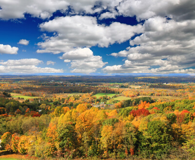
So close to the hustle and bustle of major cities, it’s hard to imagine that endless mountains, rolling hills and valleys await nearby. This scenic drive travels around the flat-topped Kittatinny Ridge, a haven for wildlife watching, hiking, water recreation and exploring charming historic towns.
Beginning at the Delaware Water Gap our scenic drive does a clock-wise loop towards Newton, but it can be done in either direction. To reach the Delaware River Gap, take exit 1 off I-80. A mere 420 million years in the making, the gap was created by shifting tectonic plates and the colliding of headwater streams, sand and rock which carved outstanding beauty through a large ridge of the Appalachian Mountains. On the New Jersey side you see Mt. Tammany and across the Delaware River in Pennsylvania is Mt. Minsi.
Stop first at Kittatinny Point Visitor Center (I1) near exit 1. Nestled at the foot of Mt. Tammany, learn about the Delaware Water Gap National Recreation Area and get information about hiking, backpacker camping and more. The visitor center is open daily from Memorial Day weekend through Labor Day weekend.
The preservation of this vast natural treasure is an important habitat for bald eagles, peregrine falcons, deer, bears, bobcat and a diverse array of plants. Leaving from the Visitor Center is Old Mine Road (T1), considered to be one of the oldest continually-used roads in the United States. The road is thought to have begun as a Paleo Indian foot trail, and used as trail wagon road used to convey American Revolutionary War regiments. Today it is a paved, narrow winding road that travels along the Delaware River and through the entire Delaware Water Gap National Recreation Area. Our scenic route follows this road. Note that Old Mine Road is closed in winter.
You begin traveling through the Worthington State Forest. Serene yet rugged, there are many trails that allow for a rigorous workout or leisurely stroll and picnic. A demanding climb to the top of Mt. Tammany at 1527 ft. above sea level rewards with stellar panoramic views. There are two trails leading up: Mt. Tammany via the Red Dot Trail is a steep and rocky 1.5 mile climb and Mt. Tammany via the Blue Blazed Trail, which is a more gradual 2.5 mile climb on wide trails. Twenty-seven miles of the Appalachian Trail pass through the Delaware Water Gap National Recreation Area. The Appalachian Trail extends along the spine of the Appalachian Mountains from Springer Mountain, Georgia, to Mt. Katahdin in Baxter State Park, Maine, traversing 2,174 miles through 14 states and is a draw for hikers.
Continuing north, Turtle Beach is a beautiful swimming spot. Opened in 2010, the site features lifeguards in summer, hiking trails and picnic areas. There is a day-use fee to enter.
Next you arrive in the historic town of Millbrook. Millbrook Village (A1) preserves 8 original buildings built in the 1800s and in the 1970s, reconstructed 17 other buildings to reflect life in that era. Tour the unique buildings, and learn more from the costumed park rangers. Don’t miss the seasonal special events. The first full weekend in October is host to Millbrook Days where the village comes alive with demonstrations of crafts and skills or on a Saturday in March (call to find out exact date), experience the fascinating Maple Sugaring Day, when sap is collected and boiled into delicious syrup. If you want to hike a less strenuous, but no less scenic section of the Appalachian Trail, consider the trailhead by the gated road on the west side of Route 602, one mile south of Millbrook Village.
In a few miles, continue on National Parks Road 615 which is arguably one of the best scenic stretches of this route, with views of Kittatinny Ridge and Flat Book to the left.
A few miles beyond, you arrive in Walpack Center (A2), a ghost town since the 1960s when people left to accommodate the proposed Tocks Island Dam. The plan was never executed and the buildings that remain in the village date from 1850 to 1950. History buffs will enjoy 1-mile one-way interpretive Military Trail which begins in front of Van Campen Inn. About 2-miles up on Mountain Road is a trail to nearby Buttermilk Falls. Cascading 200-feet down the red shale face of Kittatinny Ridge, is New Jersey’s highest waterfall. Enjoy beautiful views from the bottom or take the series of stairs up to the viewing platform at the top of the falls. If you’re game for more hiking after that, from here you can join other trails.
Continuing north, stop at the Peters Valley Craft Center (A3) which promotes traditional and contemporary crafts through exhibits, classes and residencies for artists. The gallery is open year-round displaying a diverse range of crafts from blacksmithing, ceramics, fiber, metals, photography, woodworking and more. In September, experience a craft extravaganza at the annual craft fair held in the Sussex County Fairgrounds in Augusta.
From here consider a side trip; the scenic drive meets NJ-560 which heads into Pennsylvania via the bridge to Dingmans Ferry. The Historic Dingmans Bridge built in 1900, is one of the last privately owned bridges in the country. There is a toll fee (currently $1) collected by a toll taker who stands outside, personally greeting each traveler. Before the bridge was built, this was a ferry stop in the Colonial days. From the Dingmans Falls Visitor Center (I2), a short hike brings you to Silver Thread Falls and Dingmans Falls, a 130-foot plunge into Dingmans Creek. Hiking here in July rewards with the brilliant pink blooms of native rhododendron. Located nearby within the George W. Childs State Park (H4), are three other incredible waterfalls along Dingmans Creek, Deer Leap Falls, Factory Falls and Fulmer Falls.
Back at the intersection, continue north following NJ-521 which will soon cross the US-6 and journeys briefly into New York before looping back to NJ-23.
High Point State Park (H1) is home to New Jersey’s highest peak at 1,803 feet. Climb more than 200 stairs to the top of the High Point Monument for expansive panoramas of the rolling hills, pastoral farmland and valleys of 3 states, the Pocono Mountains toward the west, the Catskill Mountains to the north and the Wallkill River Valley in the southeast. The 220-foot High Point monument is an obelisk built in 1928-1930 in honor of war veterans. There are other hikes to explore the beautiful landscaping designed by the Olmsted Brothers, including one that explores the Dryden Kuser Natural Area and Cedar Swamp. Stop in the Visitor Center for more information. Take advantage of the many interpretive and educational programs, swim in Lake Marcia, enjoy fishing and boating or tent camping and cabin rentals. Winter features ice skating, cross-country skiing, snowmobiling and ice fishing. There is a day-use fee from Memorial Day weekend to Labor Day.
Just after Colesville, the scenic drive heads south on NJ-519 where you should consider a detour to Stokes State Forest (H2) and drive to the top of Sunrise Mountain for a spectacular view. The 1,653 feet peak is the second highest in NJ. The adventurous hiker will enjoy the satisfying rewards climbing the rocky steep trail. Or stroll the Tillman Ravine Natural Area which delights with waterfalls amid lush green forest. Here you will also find water recreation and camping. Winter offerings are ice skating, cross-country skiing, snowmobiling and ice fishing. Again entrance fees are charged per vehicle from Memorial Day weekend to Labor Day.
After Branchville, the road intersects with US-206 where you should head west towards Culvers Lake and Culvers Gap, and then turn left onto NJ-521. The road snakes its way through forest and by clear lakes. In Swartswood, turn left onto Newton-Swartswood Road/NJ-622 which leads to the Swartswood State Park (H3). New Jersey’s first state park established in 1914 is an excellent location for all outdoor recreation, including summer sailing regattas and birdwatching.
Our scenic drive comes to an end (not quite looping back to the beginning) in the town of Newton. From here, consider heading south towards Trenton to explore the Delaware Valley or head east for the Wallkill.

Other Nearby Places of Interests
Sterling Hill Mine Tour and Museum (M1): At the Sterling Hill Mine Tour and Museum, peruse exhibits housed in the original mining buildings once used by the New Jersey Zinc Company. The museum is the only one in New Jersey where visitors can access an underground zinc mine 1,300 feet below and see first-hand how mining was carried on. In the Zobel Exhibit Hall explore over 20,000 mining related artifacts including local fluorescent minerals. The museum also features 1,800 square feet of displays of fluorescent minerals, a fossil discovery center and the Ellis Astronomical Observatory. There is an admission fee.
Share
 | ||||||
| Sun | Mon | Tue | Wed | Thu | Fri | Sat |
|---|---|---|---|---|---|---|
