

Mountain Loop
A loop around the Western Cascades
| Mileage | 95 miles (153 km) |
|---|---|
| DurationThe duration is an estimate of a one-way drive and does not include any stops or side-trips. | 3 hours |
| SeasonsThe seasons listed are the best seasons for this scenic drive. If Winter is not mentioned, the road may be closed during the winter. | Spring, Summer, and Fall |
| Roadways | Forest Road 20, and Washington Highways 530 and 92 |
| Gravel Roads | Yes |
| PassesSome of the adventures on this scenic drive require an admission fee that these passes cover. Please read the drive description for more information. | Northwest Forest Passes (Washington, Oregon) |
| ServicesThe cities or towns listed have either Food or Services such as gas, pharmacies, etc. | Arlington, WA▼, Darrington, WA▼, and Granite Falls, WA▼ |
| Rating | 4.0 average from 224 votes |
| My DrivesTrack your favorite scenic drives by selecting those which you want to take and those that you have taken. Using your free account, simply sign in and select My Drives. | |
| Share |

Our free Road Trip Planner will reverse the route and include the places of interests. Click the “Add to Road Trip” above to start planning your next road trip.
Send this link to your phone. Standard text messaging rates apply.
() -Get directions from your start address to the beginning of and including this scenic drive. Choose either an alternate ending or same as start.
Have more destinations? Use our free Road Trip Planner to completely plan your adventure. Click the “Add to Road Trip” above to start planning your next road trip.
Get a Park Pass
Natural areas along this route require an entrance fee used to protect and maintain our most scenic treasures. Save time by purchasing your forest passes before you go.
The Mountain Loop travels through the western Cascade Mountains. The official scenic byway starts in Granite Falls and ends in Darrington, but for this drive, we are going to make a loop starting and ending in Arlington.
To reach Arlington, take exit 208 off I-5. At the WA-9 intersection, turn left and at the next block, turn right onto E. Burke Ave. After cross the Stillaguamish River, turn right onto Arlington Heights and then at the curve, stick to right onto Jordan Street.
On Jordan Street, the drive follows the Stillaguamish River to Granite Falls. At the end, turn left onto WA-92 and then left on Mountain Loop Highway. Once on the Mountain Loop Highway, consider taking a little break from driving and visit the Granite Falls (H2) which are about one and a half miles north of the city, or the Granite Falls Fish Ladder (W1).
Just after Granite Falls, you may enjoy two hikes part of the Robe Canyon Historic Park. The first is a short, 1-mile hike on the Old Robe Trail (H4) built by early railroad workers to access the mining town of Monte Cristo. To enjoy, park on the south side of the Mountain Loop Highway at the intersection with Green Mountain Road. If you are looking for something longer, the Lime Kiln Trail (H9) is a 6.5 mile round trip.
You will be surrounded by trees more and more as you continue. This will eventually bring you to Verlot, which is a great place to check for road conditions, maps, and campsite availability at the Forest Service’s Verlot Public Service Center (I1). An interpretive trail in this area informs walkers about the areas railroad, mining, logging, and vegetation history.
A few miles after Verlot is Mount Pilchuck, famous for its panoramic view of the Cascades and Puget Sound. To enjoy this view, follow the signs for the Mount Pilchuck Viewing Area, which will take about 30 minutes of driving. Once there, you have a good view of the valley and it will only improve. You can enjoy a walk around Heather Lake (H5) which will take about 3.5 hours, or you can take a 4-mile round-trip hike to the top of Mount Pilchuck (H1) that will take around 4 hours to complete.
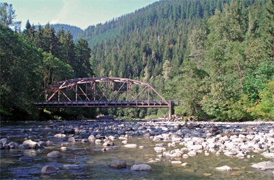
Continuing east from Verlot, there will be many cars parked on the side of the road and people enjoying the water, so do proceed with care. There are several trails in the area, including Lake Twenty-Two (H8) in the Research Natural Area. Another beautiful area is adjacent the photogenic Red Bridge (B1) which has water access and many nearby trails.
A side trip on Forest Road 4052 (T1) leads to a short, easy footpath along Deer Creek to Kelcema Lake.
One of the next towns is Big Four, named after the Big Four Mountain. There is a quaint picnic area overlooking the mountain (H3) where the Big Four Inn used to stand. The trailhead to the Big Four Ice Caves (H6) is a 1 hour hike from here, but since the caves are unstable, be sure not to walk into or on top of the caves.
An easy trail through a dense forest to a waterfall can be reached by going north on Forest Road 4060 (T2). Coral Lake is also reachable from this road.
For some great views of the South Fork Stillaguamish River, head south on Forest Road 4065 (T3).
As you approach Barlow Pass, vast and lush wilderness will start to surround you and after Barlow Pass, the paved, two-lane section of the road ends and 14 miles of gravel road begins. The road is a bit bumpy and dusty, but very approachable and drivable if you take your time. Be sure to put on your headlights, use the turn outs when you meet oncoming traffic, and enjoy the scenery by taking it slow.
You will discover one of Washington’s ghost towns next to Barlow Pass. Monte Cristo (H10) was a popular destination to prospectors, but the quality of gold and silver were low and eventually it was abandoned. It is now maintained to show visitors its history. You can reach it by taking a 4-mile hike up on the right near where the pavement ends.
For a side trip if you have a high clearance vehicle, take Forest Road 45 (T4) which travels along the North Fork Sauk River to the Glacier Peak Wilderness.
The road continues along the river, flanked by thick forest with magnificent views of granite walls until just before Darrington. In Darrington, hike the Old Sauk River Trail. This easy 6-mile roundtrip hike is flat, and rewards with moss-draped forest and views of Sauk River. In fall, the forest floor, and fallen trees sprout an amazing variety of colorful mushrooms. Get information and maps at the Darrington Ranger District (I2).
The drive officially ends in Darrington, but we recommend continuing to Arlington for more scenic views. Stroll the quaint downtown with its charming architecture, small shops and restaurants as well as easy access to I-5 by following WA-530 West. Alternatively, you could join onto the The Rockport Loop and then onto North Cascades Highway (WA-20) continuing on WA-530 East.
If you end the drive in Arlington, you can take WA-9 North to North Cascades Highway or Mount Baker Highway.

Other Nearby Places of Interests
Share
 | ||||||
| Sun | Mon | Tue | Wed | Thu | Fri | Sat |
|---|---|---|---|---|---|---|
Send this link to your phone. Standard text messaging rates apply.
() -