

North Cascades Highway
Follow the Skagit River through the Northern Cascades
| Mileage | 127 miles (205 km) |
|---|---|
| DurationThe duration is an estimate of a one-way drive and does not include any stops or side-trips. | 3 hours |
| SeasonsThe seasons listed are the best seasons for this scenic drive. If Winter is not mentioned, the road may be closed during the winter. | Spring, Summer, and Fall |
| Roadways | Washington Highway 20 |
| PassesSome of the adventures on this scenic drive require an admission fee that these passes cover. Please read the drive description for more information. | Northwest Forest Passes (Washington, Oregon) |
| ServicesThe cities or towns listed have either Food or Services such as gas, pharmacies, etc. | Winthrop, WA▼, Concrete, WA▼, Mount Vernon, WA▼, and Sedro Woolley, WA▼ |
| Rating | 4.0 average from 260 votes |
| My DrivesTrack your favorite scenic drives by selecting those which you want to take and those that you have taken. Using your free account, simply sign in and select My Drives. | |
| Share |

Our free Road Trip Planner will reverse the route and include the places of interests. Click the “Add to Road Trip” above to start planning your next road trip.
Send this link to your phone. Standard text messaging rates apply.
() -Get directions from your start address to the beginning of and including this scenic drive. Choose either an alternate ending or same as start.
Have more destinations? Use our free Road Trip Planner to completely plan your adventure. Click the “Add to Road Trip” above to start planning your next road trip.
Get a Park Pass
Natural areas along this route require an entrance fee used to protect and maintain our most scenic treasures. Save time by purchasing your forest passes before you go.
The North Cascades Highway is the first National Scenic Highway in the United States. Prepare for sweeping vistas, alpine meadows, wildlife watching opportunities and recreation galore. This mountain scenic drive begins in Sedro Woolley. To get to Sedro Woolley, take Exit 230 off of I-5 and follow WA-20 East, or head North on WA-9. Note that the North Cascades Highway is closed from mid-November to April. Check road conditions before heading out near these dates.
The drive travels alongside the Skagit River passing many farms offering seasonal bounty of apples, berries, pumpkins and honey and some featuring U-Pick experiences. Don’t miss a chance to stock up on fresh, local picnic goodies.
In twenty-four miles, you approach the town of Concrete. Giant concrete silos stating “Welcome to Concrete” will greet you. There is a small parking area if you want to take photos of the iconic signage. From Concrete, you can reach Shannon Lake (W3) and Baker Lake (W2) by following Baker River Road and Baker Lake Road to enjoy fishing, boating and water-skiing.
As you continue east on WA-20 from Concrete, lookout for eagles during winter, as this location is home to the second largest eagle gathering in the United States, the first being Alaska. Learn more about this majestic bird and its habitat during the Skagit Eagle Festival held the entire month of January with activities in Concrete, Rockport and Marblemount. The Skagit River Bald Eagle Interpretive Center located at Howard Miller Steelhead Park (H9) features eagle presentations, viewing stations and boat tours. Howard Miller Steelhead Park offers year-round tent and RV camping, fishing, rafting and hiking trails.
Rockport State Park (H1) is a beautiful, old growth forest that has never been logged. This creates a dense canopy where minimal sunlight reaches the ground and the original ecosystem still remains. Trails explore the forest and offer a chance to observe birds and wildlife. A 4.2-mile roundtrip to the summit of Sauk Mountain rewards with incredible views. The trailhead is just past Rockport State park along the gravel Sauk Mountain Road (FS 1030). Note all Washington State Parks require a day use fee or use your Discover Pass.
At Rockport, the WA-530 joins the WA-20. Our drive continues east on the WA-20. If you were to continue on WA-530 towards Darrington, you would access the Mountain Loop Highway.
As you approach Marblemount, you should note that there are very few gas stations for the next 90 miles, making this a good time to check your gas tank.
Six miles east of Marblemount is the Ross Lake National Recreation Area (H5). This area includes Ross Lake, Gorge Lake, and Diablo Lake (W1). Views of glacier-topped jagged peaks, waterfalls, rivers and lush forest are breathtaking. You will definitely want to take advantage of the many turn outs for photos.
In nine miles you arrive in Newhalem. Stop at the North Cascades Visitor Center (I2) to learn more about the area through exhibits and video presentation. From here, there are a few trails, including a recommended 200-foot paved trail to an overlook of the Picket Range, a range contained entirely within the North Cascades National Park, and a one mile hike to examine the Skagit River up close. Note the visitor center is closed from Nov. to spring. Check the Forest Service website for road conditions and dates.
Just past the Gorge Dam, stop at the Gorge Creek Falls (H6) which cascade into Gorge Lake. There is a parking area and pedestrian walkway to the overlook.
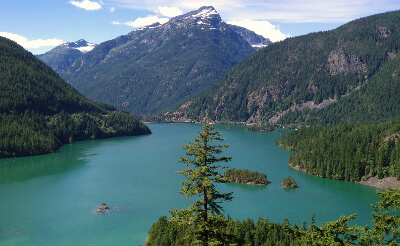
Moments after this, you will see Diablo and Diablo Lake (W1) popular with swimmers and boaters. Just after the bridge, the Lake Diablo Overlook (V1) is a must stop for incomparable views of the surrounding Cascades, Pickets, Diablo Lake, and more. The incredible emerald green color is caused by the suns reflection on glacier-ground rock dust suspended in the water.
There are many hiking opportunities for all levels. Just after the Overlook, the Happy Creek Forest Walk (H7) is an accessible boardwalk that features informative interpretive panels about the forest.
Twenty-four miles from here is the Rainy Pass Picnic Area (H10), located within the Okanogan National Forest. Take the 1 mile, accessible paved trail to Rainy Lake (W4) to examine local flora and waterfall. Up for more of a challenge? Hike the 7.2 mile Maple Pass Loop Trail (less steep counterclockwise) for outstanding views. Fall delights when golden larches and crimson huckleberry bushes blaze across the mountains. A day use fee is required to park/hike here covered by an America the Beautiful or Pacific Northwest Pass.
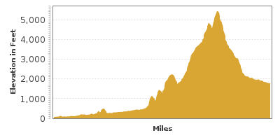
In six miles, Washington Pass (H3) is the highest elevation of the drive at 5,477 feet and you will be surrounded by the peaks of the Cascades. Amazingly, this pass once was at the bottom of the Pacific Ocean!
The drive descends steeper than the previous sections and after a hairpin turn, you will be back in a valley of farmland.
In Mazama, consider a great side trip to Harts Pass (T1), the highest driving point in the state of Washington. To get there, turn onto Lost River Road and turn left onto Goat Creek Road. Drive up Goat Creek Road, turn right onto Lost River Road, and join onto Forest Road 5400 until the end. The nearby Slate Peak has incredible panoramic views of the surrounding areas.
Our drive continues on WA-20 to Winthrop, known for the whimsical American Old West design of the town buildings. You’ll note that the climate here is remarkably drier and hotter than the first section of the drive. Winthrop is a hub for year-round recreation including horseback-riding, kayaking, rafting, fly-fishing and in winter, prime cross-country skiing. You’ll find ample dining and lodging options, as well as great shopping, making this a perfect weekend destination. Visit the Shafer Museum (M1) to learn about the Cascade Valley’s pioneer and mining history. The museum is comprised of six original buildings from the 1800’s such as the Print Shop, the Castle and General Store. Admission is by donation. Check website as hours are limited.
From Winthrop, you can continue the Cascade Loop by going to Wenatchee. The loop would continue to Stevens Pass Greenway and Whidbey Island.
If you are driving the drive in the opposite direction, WA-9 can lead you to either Mount Baker Highway by heading north or Mountain Loop Highway by heading south. Or for a ferry ride, continue to Horseshoe Highway on Orcas Island or Whidbey Island.

Other Nearby Places of Interests
Winthrop National Fish Hatchery (A1): The Winthrop National Fish Hatchery is a great place to learn about Salmon, watch wildlife, or just have a picnic. More information is available at: http://www.fws.gov/winthropnfh/.
Henry Thompson Bridge (B2): The Henry Thompson Bridge was once the longest single-span concrete bridge in the West when built in 1917.
North Cascades National Park (H4)
Pearrygin Lake State Park (H8)
Information Service in Sedro Woolley (I1)
Marblemount Ranger Station (I3)
American Museum Of Radio (M2): The American Museum of Radio celebrates the invention of the radio with exhibits, collections of vintage radios, and broadcast technology.
Whatcom Museum Of History And Art (M3): The Whatcom Museum of History and Art is a free admission museum featuring Northwest art and regional history. The museum includes Indian artifacts, logging equipment, and various items from the Victoria era.
Share
 | ||||||
| Sun | Mon | Tue | Wed | Thu | Fri | Sat |
|---|---|---|---|---|---|---|
Send this link to your phone. Standard text messaging rates apply.
() -