

Mount Baker Highway
A scenic drive to Mount Baker
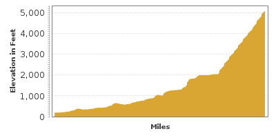
| Mileage | 46 miles (75 km) |
|---|---|
| DurationThe duration is an estimate of a one-way drive and does not include any stops or side-trips. | 1 hour |
| SeasonsThe seasons listed are the best seasons for this scenic drive. If Winter is not mentioned, the road may be closed during the winter. | All Seasons |
| Roadways | Washington Highway 542 |
| PassesSome of the adventures on this scenic drive require an admission fee that these passes cover. Please read the drive description for more information. | Northwest Forest Passes (Washington, Oregon) |
| ServicesThe cities or towns listed have either Food or Services such as gas, pharmacies, etc. | Maple Falls, WA▼, Glacier, WA▼, and Welcome, WA▼ |
| Rating | 4.0 average from 110 votes |
| My DrivesTrack your favorite scenic drives by selecting those which you want to take and those that you have taken. Using your free account, simply sign in and select My Drives. | |
| Share |

Our free Road Trip Planner will reverse the route and include the places of interests. Click the “Add to Road Trip” above to start planning your next road trip.
Send this link to your phone. Standard text messaging rates apply.
() -Get directions from your start address to the beginning of and including this scenic drive. Choose either an alternate ending or same as start.
Have more destinations? Use our free Road Trip Planner to completely plan your adventure. Click the “Add to Road Trip” above to start planning your next road trip.
Get a Park Pass
Natural areas along this route require an entrance fee used to protect and maintain our most scenic treasures. Save time by purchasing your forest passes before you go.
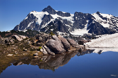
The Mount Baker Highway drive starts in Bellingham and it follows the Nooksack River to Mount Baker’s Artist Point. At 10,781 feet tall, Mount Baker is the fourth highest mountain in Washington and the sixth highest of the Cascade Mountain Range. It is the second most glaciated mountain (Mount Rainier being the first), having more snow than all other mountains combined in the range with the exception of Mount Rainier, and averages 615 inches of new snow per year. Mount Baker is also second most active volcano in the range (Mount St. Helens being the most active).
To reach the starting point, take Exit 255 from I-5 to WA-542 and follow it eastward. Our map above begins just after you cross the North Fork Nooksack River and arrive at Nugent’s Corner. In case you’re ready for a picnic already or spotting places to stop by on your way home, there is a small dirt road just after you cross the North Fork Nooksack River where you can enjoy your picnic on a rocky beach at Nooksack Corner (A1). This drive follows the North Fork Nooksack River nearly to its source, Mount Shuksan.
Washington is fortunate to have many great wineries, and the Nooksack River and Mount Baker create an excellent climate for growing wine grapes. The Mount Baker Vineyards (A2), located just a few miles before Deming, presents you the opportunity to taste some of these fine wines.
Mosquito Lake Road is a quaint side trip. At the WA-9 intersection, head south for a few miles, and it will be on your left.
The thick forest starts right around Maple Falls and this is your last chance for gas before heading up Mount Baker. For a beautiful lake, head north on Silver Lake Road for Silver Lake Recreation Area (W1). The lake is surrounded by the foothills of Mount Baker. You can walk through its forests, enjoy a picnic on the beach, or rent a boat and row around the lake.
Continuing east on WA-524, the Glacier Public Service Center (I1) will be on your right and is a great place to get updated information on road closures that may affect your plans.
Just east of the center, you can take Glacier Creek Road (Forest Road 39) for a half mile to a bridge where salmon can be spotted traveling upstream Thompson Creek (A3) to spawn. If you continue on Glacier Creek Road about 9-miles, there are great viewpoints of Mount Baker’s Coleman Glacier (V1). A 2.5-mile hike leaves from here through the forest and heads to the glacier.
The Nooksack River generally meanders through the Mount Baker Snoqualmie National Forest and it forms several waterfalls, including the Nooksack Falls (H2) which plunges down 175 feet. You can see it by following the unpaved Wells Creek Road until the bridge.
Continuing on Mount Baker Highway, you will now start climbing up Mount Baker, enjoying views of the mountain at many of the roads turnouts. There are many hikes for all skills and lengths, most starting at the Heather Meadows (H3) Visitor Center. Further up from the Visitor Center, Artist Point, marks the end of our drive. On clear days from Mount Baker, you can see the San Juan Islands, the Canadian Rockies, the Cascade Mountains, and more. Enjoy a portion of the Artist Ridge Trail (H4) to enjoy the spectacular views.
To head back home, just turn around and enjoy the road on the way back. Consider taking WA-9 just before Deming southward to the North Cascades Highway or the Mountain Loop Highway.

Other Nearby Places of Interests
American Museum Of Radio (M1): The American Museum of Radio celebrates the invention of the radio with exhibits, collections of vintage radios, and broadcast technology.
Whatcom Museum Of History And Art (M2): The Whatcom Museum of History and Art is a free admission museum featuring Northwest art and regional history. The museum includes Indian artifacts, logging equipment, and various items from the Victoria era.
Share
 | ||||||
| Sun | Mon | Tue | Wed | Thu | Fri | Sat |
|---|---|---|---|---|---|---|
