

Sherman Pass Loop
Drive around Roosevelt Lake
| Mileage | 194 miles (313 km) |
|---|---|
| DurationThe duration is an estimate of a one-way drive and does not include any stops or side-trips. | 4 hours, 30 minutes |
| SeasonsThe seasons listed are the best seasons for this scenic drive. If Winter is not mentioned, the road may be closed during the winter. | All Seasons |
| Roadways | US Highway 2, and Washington Highways 20, 21, and 24 |
| Ferry | Yes |
| PassesSome of the adventures on this scenic drive require an admission fee that these passes cover. Please read the drive description for more information. | Northwest Forest Passes (Washington, Oregon) |
| ServicesThe cities or towns listed have either Food or Services such as gas, pharmacies, etc. | Republic, WA▼, Kettle Falls, WA▼, Wilbur, WA▼, and Fruitland, WA▼ |
| Rating | 3.5 average from 60 votes |
| My DrivesTrack your favorite scenic drives by selecting those which you want to take and those that you have taken. Using your free account, simply sign in and select My Drives. | |
| Share |

Our free Road Trip Planner will reverse the route and include the places of interests. Click the “Add to Road Trip” above to start planning your next road trip.
Send this link to your phone. Standard text messaging rates apply.
() -Get directions from your start address to the beginning of and including this scenic drive. Choose either an alternate ending or same as start.
Have more destinations? Use our free Road Trip Planner to completely plan your adventure. Click the “Add to Road Trip” above to start planning your next road trip.
Get a Park Pass
Natural areas along this route require an entrance fee used to protect and maintain our most scenic treasures. Save time by purchasing your forest passes before you go.
This scenic drive is a loop that starts in Wilbur, heads north to Republic with a short ferry ride over Roosevelt Lake, goes through Sherman Pass, then south to Inchelium and a short ferry ride to Gifford Ferry, and finally back to our starting point. The drive fully encompasses the Sherman Pass Scenic Byway.
The drive begins in Wilbur heading north on WA-21. To reach Wilbur, take US-2 from Coulee City or from Spokane. The beginning of the drive features many rolling, dry hills until Roosevelt Lake. At Lake Roosevelt, there is a short, free ferry ride across the lake.
Once across, the drive continues through the Colville Indian Reservation and heads north along the Sanpoil River, fifty-three miles to Republic. The landscape features a variety of farmland and patches of trees. Some of the cows are not fenced in, so keep this in mind while driving.
Just after West Fork, the drive enters the Colville National Forest. At the entrance, the Thirteen-Mile Trailhead (H1) is on the left and provides a number of spectacular views. The 1.1 million acre forest was first shaped over 10,000 years ago by Ice Age glaciers that carved three major valleys of today’s Columbia, San Poil-Curlew, and Pend Oreille River. Three mountain ranges, the Okanogan, Kettle River, and Selkirk, are considered foothills of the Rocky Mountains. When hiking in this area, keep in mind that rattlesnakes, cougars, bobcats, black bears and other animals live here. From the road though, usually only the deer are visible.
As you approach Republic, WA-21 merges onto WA-20 and turns right. In Republic, the Stonerose Interpretive Center (M1) will inform that this area used to be under a lake some fifty million years ago and this makes the land rich in fossils. Visitors can try their hand at finding these fossils and the Stonerose Interpretive Center will supply tools, advice, samples, and more.
The official Sherman Pass Scenic Byway starts in Republic and continues until Kettle Falls. The Pass, originally a path has been used for years, first by the San Poil Indians who fished near Kettle Falls and then later by mining and logging industries until it was paved in the 1950s.
When WA-20 and WA-21 split, stay on WA-20 towards Kettle Falls. Eight miles from Republic, you once again enter the Colville National Forest. The drive winds around trees and climbs through the forest. Viewing opportunities of the surrounding peaks happen whenever there is an open pasture.
The Sherman Pass Overlook (V1) is roughly seventeen miles from Republic, and after a ten-minute walk, you will be rewarded by vistas of pristine wilderness and of course, Sherman Pass. To reach it, take the dirt road before the pass for an eighth of a mile and park. There are also other hikes in this area.
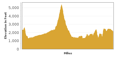
Sherman Pass (H3) lies at 5,575 feet. The Kettle Crest National Recreation Trail (H6) leads to a spectacular view from Columbia Mountain that includes Sherman Peak to the south and Wapalousie Mountain to the north. There are many great trails in this area that usually connect onto the Kettle Crest National Recreation Trail. You can also travel north on Forest Road 2030 for hikes that join the Kettle Crest Trail that starting near Sherman Pass Overlook (V1).
Just after the pass, Forest Road 2020 is on the right and brings you to some hikes around Sherman Creek (T1). Here there is an interpretive trail teaching about the areas logging history.
Continuing east on WA-20, the Log Flume Interpretive Area is eleven miles east from Sherman Pass. A trail in this area teaches you about the area’s logging history by bringing you through the forests near Sherman Creek.
For outstanding views, consider a side trip up Mount Bangs by taking Bangs Mountain Road (T2) (NF 136) which is two miles up the road from the Log Flume Interpretive Area. From here you can see into Idaho and as far north and south.
Five miles from Bangs Mountain Road, turn right onto Inchelium-Kettle Falls Road. If you were to continue east on WA-20, the drive enters the Sherman Creek Wildlife Recreation Area (H5) home to deer, bears, wild turkeys and other birds and mammals. In Kettle Falls, the Kettle Falls Ranger Station (I1) can provide you with maps and information and Saint Paul’s Mission (A1) is the oldest church in Washington and is built overlooking Roosevelt Lake, where Kettle Falls used to be. If you are interested in continuing there, see the Kettle Falls to Selkirk Mountains drive.
Heading south on Inchelium-Kettle Falls Road (Country Road 3), the drive hugs Lake Roosevelt’s coast as it travels through the Colville National Forest until Staehly Mountain where you drive through the Colville Indian Reservation again.
About twenty-three miles on this stretch of road, you will reach Inchelium, where you will want to follow the signs for the Gifford-Inchelium Ferry. The ferry is fairly regular but while waiting, take a walk to see the Columbia River which you will be crossing shortly.
Once across the river, take WA-25 South, which for the first several miles will hug the shoreline. Traveling through the Spokane Indian Reservation just after Enterprise, the cattle are unfenced again.
Cross the Fort Spokane (H2) Bridge over the Spokane River and turn right onto Miles Creston Road North. This road drives along Roosevelt Lake and with its twists and turns will bring you to an area where basaltic rocks seem to have grown from the earth.
At the end of the Miles-Creston Road, you will be at US-2 and our drive continues west by turning right. You will travel by wheat fields and our drive ends in Wilbur in about ten miles where our drive started. From here, consider driving to the Spokane River Loop to the East of here or to the Coulee Corridor Scenic Byway to the west.

Other Nearby Places of Interests
Trout Lake and Hoodoo Canyon (H4)
Log Flume Interpretive Site (H7)
Republic Visitor Information Center (I2)
Kettle Falls Historical Center Museum (M2)
Share
 | ||||||
| Sun | Mon | Tue | Wed | Thu | Fri | Sat |
|---|---|---|---|---|---|---|
