

Oak Creek Canyon
From Flagstaff to Sedona
| Mileage | 26 miles (42 km) |
|---|---|
| DurationThe duration is an estimate of a one-way drive and does not include any stops or side-trips. | 34 minutes |
| SeasonsThe seasons listed are the best seasons for this scenic drive. If Winter is not mentioned, the road may be closed during the winter. | All Seasons |
| Roadways | US Highway 89A |
| PassesSome of the adventures on this scenic drive require an admission fee that these passes cover. Please read the drive description for more information. | Red Rock Pass for Coconino National Forest (Arizona) |
| ServicesThe cities or towns listed have either Food or Services such as gas, pharmacies, etc. | Bellemont, AZ▼, Flagstaff, AZ▼, Munds Park, AZ▼, and Sedona, AZ▼ |
| Rating | 3.8 average from 48 votes |
| My DrivesTrack your favorite scenic drives by selecting those which you want to take and those that you have taken. Using your free account, simply sign in and select My Drives. | |
| Share |

Our free Road Trip Planner will reverse the route and include the places of interests. Click the “Add to Road Trip” above to start planning your next road trip.
Send this link to your phone. Standard text messaging rates apply.
() -Get directions from your start address to the beginning of and including this scenic drive. Choose either an alternate ending or same as start.
Have more destinations? Use our free Road Trip Planner to completely plan your adventure. Click the “Add to Road Trip” above to start planning your next road trip.
Get a Park Pass
Natural areas along this route require an entrance fee used to protect and maintain our most scenic treasures. Save time by purchasing your forest passes before you go.
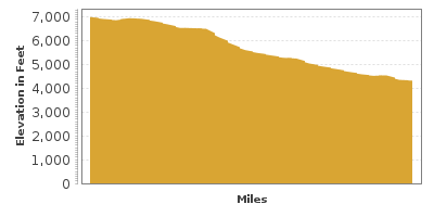
The 2,000-foot deep Oak Creek Canyon stretches for over 12-miles along a fault line. This drop in elevation is fully explored on this scenic drive which travels through the lush forests of Flagstaff and explores the glorious red-rock deserts, unique rock formations and rainbow-colored sandstone-cliffs on the way to Sedona.
Leaving the San Francisco Peaks behind in Flagstaff, travel towards Sedona via the US-89A. To begin, from S. Milton Road, turn right on W Forest Meadows Street, and turn left onto Arizona 89A.
Driving south on US-89A, you enter the Coconino National Forest. Take advantage of the many picnic areas, such as the Lindbergh Spring Roadside Park (H1), where you can lunch by one of the world’s largest ponderosa pine forests. Note that throughout the drive, all parked vehicles along the highway or at trailheads are required to display a Red Rock Pass or an America the Beautiful Pass.
In a few miles, you arrive at the Oak Creek Canyon Overlook (V1) where you will be rewarded with spectacular views of the Mogollon Rim (the southern border of the Colorado Plateau), the magnificent shades of reds and whites that color the canyon, and the vast firs that populate the surrounding forests. For a better view, a short loop trail leads to where the canyon just drops down some 2,000 feet. From here, it’s easy to observe the geology and witness the climate change as towards to south, you begin to see the dry, cactus-filled deserts.
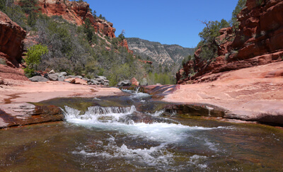
The road descends a series of switchbacks until you arrive at the Pumphouse Wash Bridge. Sandstone cliffs, reflective pools and small cascades await. Shortly afterward, one the area’s most popular hikes leaves from the Cave Springs Campground’s Call of the Canyons Day Use Area. The 3-mile West Fork Trail (H2) passes wildflower meadows frequented by hummingbirds and butterflies as it winds deep into the maze of canyons. Portions of the hike require you to walk through ankle-deep streams, so be prepared. Many other hikes leave from this area. This day-use area charges an entrance fee not covered by either pass.
The road continues along Oak Creek with many pullouts for picnics and views. One recommended stop is Slide Rock State Park (W1). A popular escape from Arizona’s summer heat, slide down the slippery algae-covered sandstone chute that leads to the cool, Oak Creek. Listed as one of America’s ten best swimming holes, arrive early if you want a parking spot.
Along the route are lodging opportunities, quaint cafes and open air stands selling Native American jewelry and crafts. Enjoy warmer temperatures and observe the geology as heading south, you begin to see the dry, cactus-filled deserts.
Consider a side trip to the Palatki Ruins, a designated World Heritage Site. Visit cliff dwellings, pictographs and petroglyphs created by the Southern Sinagua people. Reservations are required to visit: (928) 282-4119. Take the unpaved Forest Road 525 heading north to get there.
Grasshopper Point Swimming Hole (W2) is another great spot without the crowds of Slide Rock Park. After a slight trek from the parking lot, stunning scenery, amazing rock formations and several pools of Oak Creek’s refreshingly cool water await. The brave can scale the cliffs and take the 25 foot jump into the deep waters.
Stop on the north side of the Midgely Bridge, for an amazing view of Sedona and the Wilson Canyon. The Wilson Mountain Trail (H4) leaves from here and explores the Red Rocks-Secret Mountain Wilderness via a strenuous 5.6-mile trail with high-elevation gain, but the views are well worth the hike.
The scenic drive comes to an end about two miles after the bridge when you arrive in Sedona. The town of Sedona is bustling and geared for tourists featuring many unique shops and restaurants amid spectacular setting. From here, don’t miss a short drive along the incredible Red Rock Scenic Byway on AZ-179. Other options are to drive on Schnebly Hill Road (T1) to wind through Bear Wallow Canyon, continue down US-89A until Prescott, or to head north towards the Grand Canyon.

Other Nearby Places of Interests
Walnut Canyon National Monument (A1): Within the ledges of Walnut Canyon, Sinagua Native Americans built cliff dwellings deep in the canyon walls and lived here for 150 years until they disappeared from history. Explore 25 cliff dwelling rooms with the 1-mile round trip Island Trail.
Chapel of the Holy Cross (A2): One of Sedona’s most magnificent man-made structures. Built into the red rock mesas, the Chapel is open to all faiths. Cathedral Rock rises a few miles to the southwest of the building and the chapel offers a spectacular view.
Verde Canyon Railroad Excursion Train (A3): Sometimes it is surprising that there are areas unreachable by roads. Portions of the Verde River Canyon are not, but fortunately, the Verde River Canyon Excursion Train provides a way to explore the canyon. The 40-mile round trip departs from Clarkdale and brings you to the Perkinsville ghost town and back in about 4.5 hours.
Little Horse Trail (H3): Little Horse Trail heads through the rock formations within the Coconino National Forest on the Colorado Plateau, including Cathedral Rock. The trail is a short 1.5-mile easy hike.
Bell Rock Pathway (H5): The Bell Rock Pathway is a 3.5-mile trail that connects the towns of Oak Creek and Sedona. The path provides spectacular views of Bell Rock, Courthouse Butte, and many other amazing rock formations. The trail is fairly easy, with a few steep and rough areas.
Red Rock State Park (H6): Red Rock State Park is one of the newest state parks and aims to maintain the park as natural as possible. Hundreds of bird species stop at Oak Creek. Explore the park through its network of trails, including the Eagle’s Nest and Smoke Trail.
Sycamore Canyon (H7): Sycamore Canyon is adjacent to the Oak Creek Canyon and just as spectacular, only without the crowds. Since the canyon floor can reach temperatures above 100 degrees, it’s not recommended for a summer adventure.
Dead Horse Ranch State Park (H8): Dead Horse Ranch State Park is situated on the Verde River and is surrounded with desert. The park offers camping, fishing (bass, panfish, and trout are regularly stocked), and many trails that provide access to the Verde River.
Tuzigoot National Monument (H9): Tuzigoot National Monument celebrates the ancient Sinagua people who lived and farmed in this area during the 1100s. At Tuzigoot, you will see their two story apartment-style architecture that homed as many as 250 people.
Bell Rock Vista (V2): This stop offers a spectacular view of the Bell Rock Butte, a landmark which dominates the landscape. To explore the butte, consider the Bell Rock Pathway which is about a half of mile south of this viewpoint.
Share
 | ||||||
| Sun | Mon | Tue | Wed | Thu | Fri | Sat |
|---|---|---|---|---|---|---|
