

Grand Canyon Loop
Flagstaff to the Grand Canyon and Sunset Crater Volcano National Monument
| Mileage | 201 miles (324 km) |
|---|---|
| DurationThe duration is an estimate of a one-way drive and does not include any stops or side-trips. | 4 hours, 50 minutes |
| SeasonsThe seasons listed are the best seasons for this scenic drive. If Winter is not mentioned, the road may be closed during the winter. | Spring, Summer, and Fall |
| Roadways | Arizona Highway 64, US Highways 180 and 89, and Loop Road |
| PassesSome of the adventures on this scenic drive require an admission fee that these passes cover. Please read the drive description for more information. | America the Beautiful Resident Annual National Parks Pass 2026-2027 |
| ServicesThe cities or towns listed have either Food or Services such as gas, pharmacies, etc. | Bellemont, AZ▼, Gray Mountain, AZ▼, Grand Canyon Village, AZ▼, Flagstaff, AZ▼, Cameron, AZ▼, Tusayan, AZ▼, Valle, AZ▼, and Desert View, AZ▼ |
| Rating | 4.0 average from 145 votes |
| My DrivesTrack your favorite scenic drives by selecting those which you want to take and those that you have taken. Using your free account, simply sign in and select My Drives. | |
| Share |

Our free Road Trip Planner will reverse the route and include the places of interests. Click the “Add to Road Trip” above to start planning your next road trip.
Send this link to your phone. Standard text messaging rates apply.
() -Get directions from your start address to the beginning of and including this scenic drive. Choose either an alternate ending or same as start.
Have more destinations? Use our free Road Trip Planner to completely plan your adventure. Click the “Add to Road Trip” above to start planning your next road trip.

Get a Park Pass
Natural areas along this route require an entrance fee used to protect and maintain our most scenic treasures. Save time by purchasing your forest passes before you go.
Snow-capped San Francisco Peaks, Kaibab National Forest and the intense colors of light and shadow stretching across the rocks, buttes, and spires of the Grand Canyon await as this scenic drive explores 2 billion years of the earth’s history.
This scenic route begins in Flagstaff, which you can reach from I-40 or US-89. From the west on I-40, take exit 191 onto I-40 Bus. In 4 miles, turn left onto Fort Valley Road/US-180 where our drive begins. From the east on I-40, take exit 198, turning right towards I-40 Bus, and then left onto I-40 Bus/US-180, where in 1.5 miles, turn right onto US-180 to stay onto US-180 (Fort Valley Road).
Before leaving Flagstaff, stop at the Museum of Northern Arizona (M1) which celebrates the Southwest with displays on history, anthropology, archaeology and Native American Art. Pioneer Museum (M2) is also nearby and showcases northern Arizona’s early history, ranching, logging and transportation.
Gazing at the ancient volcanoes of San Francisco Peaks, head north on US-180 through ponderosa pine forests and beautiful open meadows. 7-miles from Flagstaff, you arrive in the town of Fort Valley. Take Snow Bowl Road (T1) (some maps refer to this as Forest Road 516) for spectacular views of the San Francisco Peaks. The San Francisco Peaks is actually a single, dormant volcano that looked similar to Mount Fuji several hundred thousand years ago before a side-ways eruption which, smoothed by glaciers, created the shape we see today. The Snowbowl ski area offers year-round recreation. Take the chairlift to Agassiz Peak at 11,500 feet. A 9-mile round-trip hike will bring you to Humphreys Peak. At 12,633 feet, it is Arizona’s tallest mountain and views are simply breathtaking. This alpine environment is a unique and fragile ecosystem. Some areas are closed to foot traffic and on Humphreys Peak, you must stay on designated trails.
Continuing north on US-180, you arrive at Kendrick Park. The forest and grassland habitats are an ideal location to spot wildlife on the Kendrick Park Watchable Wildlife Trail (H1). Mule deer, coyote, badger, elk, red-tailed hawk and much more can be seen here from two interpretive trails. One is a short 1/4 mile loop paved for wheelchair access while the other is one and half mile, not paved, but relatively flat trail. Bring binoculars and walk and talk softly for best viewing.
Heading north, the road travels through a lava field and opens up to the volcanic Slate Mountain and Red Mountain. Take a side-trip on Forest Road 191. A 2.4-mile one way hike will bring you to the summit of Slate Mountain (H2), where your efforts will be rewarded with spectacular panoramic views of the San Francisco Peaks, Kendrick Mountain, Red Mountain, the Grand Canyon and Painted Desert. Or visit Red Mountain (H3) one of hundreds of cinder cones in the area. Experience the unique opportunity to see the exposed internal structure, hoodoos and crystals caused by erosion.
After Red Mountain, the road descends to a drier climate of piñon pine and junipers. Take advantage of the turnouts to enjoy incredibly stunning views of the San Francisco Peaks. In 19-miles, you arrive in Valle where the road merges onto AZ-64.
In 9-miles from Valle, Red Butte welcomes you to the Kaibab National Forest. If you’re up to a challenging hike, consider the Red Butte Look Out Trail Head (H4). In 1.25-miles, it climbs 6,460 feet to a fire lookout and expansive views in all directions. Red Butte is a lava capped remnant of rock layers and is sacred to the Havasupai Indian Tribe, the only permanent residents of the Grand Canyon. Please treat it with respect.
An easier trail to explore the Kaibab National Forest departs from Ten-X Campground (H5), where you have a good chance of seeing wildlife, including mule deer, mountain chickadees, and white-breasted nathatches. Stop at the Tusayan Ranger District (I1) for more information about nearby hikes, plants and wildlife.
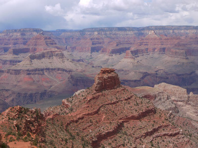
A few miles from Tusayan, you arrive at the south rim of the Grand Canyon. The magnificent sight before you is surreal. One of the Seven Natural Wonders of the World, the blazing color of multi-hued cliffs, stacks of buttes, carved gorge and valleys will leave you awestruck. In what seems a beautiful but barren landscape, it is host to a variety of plants and mammals, reptiles, amphibians, insects and birds including the once nearly extinct California condor, Chuckwalla lizard and a few poisonous creatures, the female black widow spider, scorpions and The Grand Canyon Rattler and the Diamond Back Rattler.
Over millions of years, the Colorado River has carved the Canyon 1-mile deep and 18-miles across. Add plate tectonics, wind, temperature, volcanic history and you create sheer indescribable beauty. Just outside of Grand Canyon Village, Mather Point (V1) is one of the finest views. Immerse yourself with this incredible panoramic view of textured rock revealing geologic history, layers of color, plants clinging to the harsh environment and the sun dancing across. From Mather Point, you can see many of Grand Canyon’s most popular features, including Bright Angel Canyon, Isis Temple, and Wotan’s Throne. While taking in the enormity of what you are seeing, keep in mind that only 1/4 of the Grand Canyon can be seen from here!
Turning left onto South Entrance Road from AZ-64 leads to Grand Canyon Village, which is always bustling with activity. Lodging, dining, shopping and information on every aspect of getting the most out of your visit to the Grand Canyon can be found here.
When hiking remember park rules and do not attempt to hike from the rim to the river in one day and have plenty of water, snacks, food. Popular with overnight hikers is Bright Angel Trail (H6). The trailhead begins just west of Bright Angel Lodge and is a 9-mile hike down to the Colorado River. If you’re not up to the whole hike and camping overnight (which requires a permit) explore the inner canyon by heading just to One-and-a-Half-Mile or Three-Mile Resthouses or Indian Garden (4.6 miles) stops along the way. Or consider renting a mule — in advance. The Rim Trail begins from any viewpoint in Grand Canyon Village. Part of the trail is paved and has minimal elevation change. You can customize this hike by using shuttle buses to return.
Stop at Yavapai Point (V2) for more than just breathtaking views. The Yavapai Geology Museum offers a glimpse into the formation of the Grand Canyon over the last 2 billion years. If you happen to visit during stormy day, the museum is an excellent way to escape the weather while still enjoying the Grand Canyon.
Before leaving Grand Canyon Village, consider a trip down West Rim Drive (T2), for 9-miles to Hermits Rest. The roads offers many pullouts, each with unique, spectacular views. The road is closed to private cars most of the year except winter (December through February), but is open for bicycles, walking or take advantage of the free shuttle which stops at all the overlooks. The Rim Trail follows for 7.8 miles along Hermit Road.
Leaving Grand Canyon Village, head east on AZ-64. Yaki Point Road and Kaibab Trail Parking Lot are closed to private cars year-round so use the shuttle bus. At Yaki Point (V4), experience the wonderful views from the South Kaibab Trail. A 6.3-mile hike with steep elevation and many switchbacks leads to the mighty Colorado River where the temperature is much hotter. But remember that all the distance you go down, you also need to go back up. Bring plenty of water and snacks, and leave yourself enough time. If not for the hike, the view is worth the stop, especially gazing down at the switchbacks of the trail.
Continuing east on AZ-64, you arrive at Grandview Point (V5). A favorite stop with excellent views of Horseshoe Mesa, Angels Gate, Vishnu Temple, and the ever changing colors of the Grand Canyon.
In a few miles, stop at Moran Point (V6) to pay tribute to landscape painter Thomas Moran. During his travels to the West in the late 1800s his paintings ultimately persuaded the United States government to create the Grand Canyon National Park.
Visit the Tusayan Museum (M3). A self-guided trail leads through an 800-year-old restored Tusayan ruin once inhabited by ancestors of the local Hopi Native Americans who resided in cliff dwellings. The museum features pottery, arrowheads and artifacts.
Shortly afterward, the Lipan Point (V7) offers an expansive view of the Colorado River snaking through the canyon, forming a perfect S, as it makes its way west. Desert View (V8) offers another amazing panoramic vista from the base of the watchtower. Designed by Mary Colter in 1932, to blend in with the natural scenery and mimic Anasazi architecture, climb the three stories staircase to murals by Hopi painter Fred Kabotie and views of Marble Canyon to Painted Desert.
From here, the drive continues east, descending from the plateau to a desert environment. In 13-miles, the drive picks up the Little Colorado River Gorge (V9). Little Colorado River offers an opportunity to see what the Grand Canyon would have looked like millions of years ago. There are many turnouts to enjoy. This area is also well known for dinosaur footprints from the Triassic Period.
16-miles further, the AZ-64 ends as it joins US-89. To visit the North Rim, head north on US-89 towards Cameron and the Kaibab Plateau or Monument Valley, but for this drive, head south on US-89. The drive continues through the dry, desert environment, passing very interesting rock formations, until you reach Loop Road about 20-miles from where you joined onto US-89.
Turning left onto Loop Road will bring you to the Wupatki National Monument and the Sunset Crater Volcano National Monument. The entire loop is about 42-miles, and well worth the side-trip. The Wupatki National Monument (A2) was most likely the largest and most influential pueblo in the area. It featured 100 rooms, a tower and community gathering rooms built nearly a thousand years ago. The ruins are sprinkled along the drive, and while hiking is permitted, stay on the trails and do not take anything to preserve the archeological information.
Continuing on Loop Road, stop at Painted Desert Vista (V10). Cinder cones, lava flows and buttes dot the terrain creating a rainbow of colorful mineral encrusted rocks that stretches for over 160 miles. Sunset Crater Volcano National Monument (H7), is a perfectly symmetrical crater that rises up 1,000 feet. Remnants of a volcanic eruption between 1040-1100, explore the area by hiking the 1-mile loop Lava Flow Trail or climb a cinder cone on the steeper 1-mile Lenox Crater Trail. Stunning shades of red from oxidization of iron and sulfur contrast with wildflowers and trees amidst a backdrop of the San Francisco Peaks in the distance. Just before Sunset Crater, consider a side-trip on Forest Road 422 to Grand Falls (V11). Beside the Grand Falls Campground is a beautiful, 185-foot waterfall. It is famous for its muddy flow creating what looks like a chocolate fountain into Little Colorado River below. The falls are best early spring when the snow is melting.
At the end of Loop Road, it rejoins the US-89 and the drive continues south until you arrive back in Flagstaff. Take a short side-trip to Walnut Canyon National Monument (A3) where the Sinagua Native Americans built cliff dwellings deep in the canyon walls and lived here for 150 years until they disappeared from history. Explore 25 cliff dwelling rooms with the 1-mile round trip Island Trail.
If you are arriving in the evening, visit the Lowell Observatory (A1). At 7,000 feet of elevation, it offers a unique experience to gaze at the stars and planets with public access to a 4.3-meter telescope. There are planetarium and multi-media shows as well.
From here, consider heading south on US-89A for the Oak Creek Canyon Scenic Drive and continuing onto the Red Rock Scenic Byway. Or head north on US-89A towards the North Rim on our Kaibab Plateau Scenic Drive.

Other Nearby Places of Interests
Lindbergh Spring Roadside Park (H8)
Share
 | ||||||
| Sun | Mon | Tue | Wed | Thu | Fri | Sat |
|---|---|---|---|---|---|---|
