
Rocky Mountain National Park
Trail Ridge Road
| Mileage | 46 miles (74 km) |
|---|---|
| DurationThe duration is an estimate of a one-way drive and does not include any stops or side-trips. | 1 hour, 32 minutes |
| SeasonsThe seasons listed are the best seasons for this scenic drive. If Winter is not mentioned, the road may be closed during the winter. | Spring, Summer, and Fall |
| Roadways | US Highway 34, and Trail Ridge Road |
| PassesSome of the adventures on this scenic drive require an admission fee that these passes cover. Please read the drive description for more information. | America the Beautiful Resident Annual National Parks Pass 2026-2027 |
| ServicesThe cities or towns listed have either Food or Services such as gas, pharmacies, etc. | Estes Park, CO▼, Loveland Heights, CO▼, Waltonia, CO▼, and Grand Lake, CO▼ |
| Rating | 4.0 average from 86 votes |
| My DrivesTrack your favorite scenic drives by selecting those which you want to take and those that you have taken. Using your free account, simply sign in and select My Drives. | |
| Share |

Our free Road Trip Planner will reverse the route and include the places of interests. Click the “Add to Road Trip” above to start planning your next road trip.
Send this link to your phone. Standard text messaging rates apply.
() -Get directions from your start address to the beginning of and including this scenic drive. Choose either an alternate ending or same as start.
Have more destinations? Use our free Road Trip Planner to completely plan your adventure. Click the “Add to Road Trip” above to start planning your next road trip.
Get a Park Pass
Natural areas along this route require an entrance fee used to protect and maintain our most scenic treasures. Save time by purchasing your forest passes before you go.
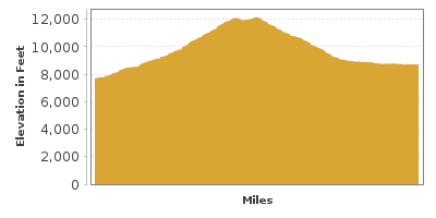
Rocky Mountain National Park has more than 110 peaks above 10,000 feet of elevation, more than half of those being over 12,000 feet. Traveling on the Trail Ridge Road, you will reach an altitude of 12,183 feet on the longest continuous mountain road in the United States. The road took 3 years to build and opened in 1932. Enjoy endless snowy peaks, lush valleys, hundreds of lakes, and unpredictable weather.
The scenic drive begins in the town of Estes Park and is a wonderful extension of the Peak to Peak Scenic Byway. This drive travels over the Continental Divide, to the Colorado River’s headwaters, and ends in the town of Grand Lake. You can reach Estes Park by following US-36 from Boulder or US-34 from Loveland. The road is open typically from May through late October.
To the south of Estes Park is the remarkable Longs Peak flat summit at 14,259 feet, the tallest mountain in Rocky Mountain National Park. Enos Mills met John Muir in 1889 and became a naturalist himself and is best known for being the “Father of Rocky Mountain National Park”. His efforts came to fruition in 1915. A short nature trail brings you to the Enos Mills Cabin Museum (M2), now on the Register of Historic Places, where you can see some of his photography and books. Mills climbed Longs Peak nearly 300 times.
Before departing the town of Estes Park, consider a stop at Stanley Museum (M1) which features exhibits of steam cars, including the 1909 Model R Stanley Roadster, paintings, photographs and more as well as the history of the Stanley Hotel, the first luxury hotel in this area. It was built by F. O. Stanley who invented the Stanley Steamer automobile.
From downtown, follow US-34, passing Stanley Hotel and through the forests into Rocky Mountain National Park. An entrance fee is charged which is covered by the America the Beautiful Pass. Stop at the Fall River Visitor Center for maps, books or a ranger-led walk.
Two miles into the National Park, you will arrive at West Horseshoe Park, where Sheep Lakes attracts bighorn sheep, deer and elk. Proceed with caution as animals and people may be crossing the road.
For those interested in getting literally off-the-beaten-path, try this adventurous side trip. Near the next bend, Old Fall River Road is on your right. This 10.5 mile gravel road is the original 1921 one-way road through Rocky Mountain National Park and the first road to cross the Continental Divide. The route passes Chasm Falls, heads over Fall River Pass, and rewards with sweeping views and many chances of seeing wildlife. At the end of the road, it rejoins US-34. The road is never plowed and is only open to traffic between July and September.
Our scenic drive continues from Sheep Lakes. After the Horseshoe Park Overlook (V1), the road merges with US-36. Turn right to continue our drive on US-34. The road starts climbing a series of switchbacks with a few great overlooks.
Two miles up the road is a boardwalk to the beaver ponds where busy beavers are at work. Since moving here in the 1950s, they have built amazing dams that shifted the water from a stream to ponds. The Park Service has also introduced greenback cutthroat trout here, saving it from near extinction. The next bend has a parking area for a nice picnic spot.
Mountain peaks, ponderosa pine and aspen fill the view of every direction. Around the next bend is the Many Parks Curve Overlook (V2) with panoramic views of Moraine Park, Horseshoe Park, stunning glacier-carved valleys and incredible mountain peaks.
Continuing up Trail Ridge Road, you pass a sign that says you are now 2 miles above sea level. The elevation changes in this drive are exceptional offering montane forests of aspen and ponderosa pine, sub alpine forests of fir and spruce and at the tree-line, an alpine tundra of stunted trees clinging to rock. Stop at the Rainbow Curve Overlook (V3) for views of a large canyon and many of the park’s best-known peaks.
Driving north, the trees become increasingly weathered until you reach the treeline and see the rolling hills of short grass and wildflowers that make up the tundra. Forest Canyon Overlook (V4) provides not only a great vantage point to see the weather-imposed growth-stunted trees, but also an amazing U-shaped glacial valley known as Forest Canyon. A boardwalk leads to a display that identifies all of the peaks before you.
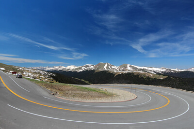
The road continues with unending spectacular views of snow-capped craggy mountain peaks in contrast with blue skies and green valleys. At Rock Cut, hike the 1-mile Tundra Communities Trail (H1). The easy trail is paved to protect the delicate plants that grow here. It can take years to repair the damage of a wayward footstep. Interpretive displays along the trail teach you about the tundra and how plants adapt to handle this harsh environment. At 12,000 feet of elevation be aware of the thin air.
The road continues to climb, reaching its highest point, 12,183 feet, just before the Gore Range Overlook (V5). Surrounded by more fabulous views, the Alpine Visitor Center (I3) features exhibits on life within the tundra, get information about hikes, and more. Bighorn sheep, pikas and marmots can be seen here.
Leaving the visitor center, the road quickly descends to the hairpin Medicine Bow Curve. Still feeling like you’re at the top of the world, the next pullout overlooks Medicine Bow Mountains and Cache la Poudre River.
Continuing the decent, the road reenters alpine forest and opens up as you arrive at the serene Poudre Lake (W1) which is open for fishing. Just after the parking lot is the Continental Divide, where all water east of the lake flows towards the Atlantic and all water west of here flows to the Pacific.
Two miles after the Continental Divide, is the Fairview Curve Overlook (V7) which provides a beautiful perspective onto the glacier-carved Kawuneeche Valley and Never Summer Mountains. The word Kawuneeche means “valley of the coyote” in Arapaho, but coyotes are usually heard more often than seen. Do keep your eyes open for moose. In the distance to the west, you will notice a little stream, better known as the Colorado River.
From this stop, you may see a line cutting across the Never Summer Mountains. This line is actually the Grand Ditch, a water diversion project built between 1890 and 1936 that feeds 20-40% of water from the Never Summer Mountains into Cache la Poudre River for farm irrigation. While the project helps farmers, it also changes the ecology of the mountains and many naturalists have fought to reduce the impact of the ditch.
The road continues to descend through the forest with many wild curves ahead. Two miles after the last hairpin curve, the Colorado River Trailhead (H2) will be on your right. The Colorado River begins here in the Rocky Mountains and continues west to the Gulf of California. The 7.1-mile round-trip trail follows the Colorado River with glorious views of the Never Summer Mountains where it ends in Lulu City, an old mining town.
Immediately afterward, the Timber Lake Trailhead (H3) is on your left, where a 4.8-mile one way strenuous hike heads through alpine forest with wide, wildflower-covered meadows on the way to Timber Lake. Other trails branch off, such as the trail to Mount Ida’s summit.
Continuing the drive, Beaver Ponds Picnic Area (H4) on your right and further up the road is Holzwarth Historic Site, sometimes referred to as Never Summer Ranch. The area surrounding the 1920s-style dude ranch can be explored by a short .5-mile walk from the parking lot.
The road descends and you will notice a difference in the temperature and moisture on the west side of the Continental Divide. Just before exiting the Park, the Rocky Mountain National Park Visitor Center at Kawuneeche (I4) is on your left. Exhibits will examine the differences between both sides of the Continental Divide and explore some of the wildlife and plants in this area.
Our scenic drive comes to an end as you exit the park. From here, continue to Grand Lake and the Colorado River Headwaters Byway.

Other Nearby Places of Interests
Holzwarth Historic Site (A1): Holzwarth Historic Site is sometimes referred to as Never Summer Ranch. The area surrounding the1920s-style dude ranch can be explored by a short .5-mile walk from the parking lot.
Chapel on the Rock (A2): Chapel on the Rock blends in as part of the natural landscape sitting atop a massive granite rock and built from local stone. The Saint Catherine of Siena Chapel is famed for a visit from Pope John Paul II who stayed here and walked the trails in 1993. The chapel is open to the public.
Longs Peak Trail (H5): The Longs Peak Trail is a moderately difficult 15-hour round-trip hike to the summit, and those adventurous enough will be rewarded with the grandest views of the Rocky Mountains.
Rocky Mountain National Park Welcome Center (I1): Orient yourself to the Rocky Mountain National Park at this Welcome Center just off Entrance Road.
Fall River Visitor Center (I2)
Old Fall River Road (T1): For those interested in getting literally off-the-beaten-path, try this adventurous side trip. Near the next bend, Old Fall River Road is on your right. This 10.5 mile gravel road is the original 1921 one-way road through Rocky Mountain National Park and the first road to cross the Continental Divide. The route passes Chasm Falls, heads over Fall River Pass, and rewards with sweeping views and many chances of seeing wildlife. At the end of the road, it rejoins US-34. The road is never plowed and is only open to traffic between July and September.
Medicine Bow Curve Overlook (V6): The Medicine Bow Curve is a hairpin curve descending from the Alpine Visitor Center. The Medicine Bow Mountains can be seen from the overlook.
Lily Lake (W2): Once filled with lilies, Lily Lake is visited by migratory birds, including ring-necked ducks, mallards, and Canadian geese.
Share
 | ||||||
| Sun | Mon | Tue | Wed | Thu | Fri | Sat |
|---|---|---|---|---|---|---|
Send this link to your phone. Standard text messaging rates apply.
() -