
Journey Through Time Scenic Byway
55 Million Years of History
| Mileage | 277 miles (447 km) |
|---|---|
| DurationThe duration is an estimate of a one-way drive and does not include any stops or side-trips. | 5 hours, 46 minutes |
| SeasonsThe seasons listed are the best seasons for this scenic drive. If Winter is not mentioned, the road may be closed during the winter. | Spring, Summer, and Fall |
| Roadways | Oregon Highways 19, 218, and 7, and US Highways 26 and 97 |
| PassesSome of the adventures on this scenic drive require an admission fee that these passes cover. Please read the drive description for more information. | America the Beautiful Resident Annual National Parks Pass 2026-2027 |
| ServicesThe cities or towns listed have either Food or Services such as gas, pharmacies, etc. | Rufus, OR▼, Biggs Junction, OR▼, Wasco, OR▼, Wishram, WA▼, Wishram Heights, WA▼, Dayville, OR▼, John Day, OR▼, and Baker City, OR▼ |
| Rating | 4.1 average from 47 votes |
| My DrivesTrack your favorite scenic drives by selecting those which you want to take and those that you have taken. Using your free account, simply sign in and select My Drives. | |
| Share |

Our free Road Trip Planner will reverse the route and include the places of interests. Click the “Add to Road Trip” above to start planning your next road trip.
Send this link to your phone. Standard text messaging rates apply.
() -Get directions from your start address to the beginning of and including this scenic drive. Choose either an alternate ending or same as start.
Have more destinations? Use our free Road Trip Planner to completely plan your adventure. Click the “Add to Road Trip” above to start planning your next road trip.
Get a Park Pass
Natural areas along this route require an entrance fee used to protect and maintain our most scenic treasures. Save time by purchasing your forest passes before you go.
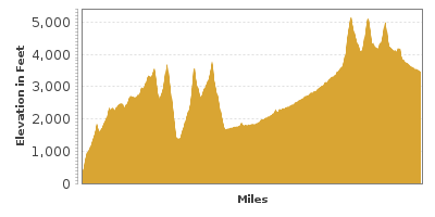
The Journey of Time Scenic Byway stretches 286 miles from Biggs Junction to Baker City through north central to eastern Oregon. Home to some of the richest fossil beds on Earth, the star of this drive is the John Day Fossil Beds National Monument but along the way you will be charmed by the Old West culture and small towns that reveal the lives of early Pioneers and their gold mining, ranching and logging history.
Ideally you should plan on two days minimum to fully explore this region. Encompassing 14,000 acres, the John Day Fossil Beds National Monument is divided into three separate units, Clarno, Sheep Rock and Painted Hills, approximately one hour away from each other.
This road travels through remote and sparsely inhabited areas. Be sure to have a full tank of gas before beginning this drive and fill up or top off whenever you see a gas station as many of the small towns do not have gas stations. There is limited cell phone coverage and restaurants and lodging are separated by large distances so bring snacks and have your hotel or campground reserved. We also recommend having drinking water on hand as summer temperatures are hot — well into the 90s. Don’t let this keep you from exploring this region — be prepared and you will be well rewarded with stunning and unusual landscapes.
We describe the drive starting in Biggs Junction US-97 heading south (from the intersection of I-84), but it can be done in reverse or picked up anywhere along the byway. The drive follows the John Day River, designated a wild and scenic river and the longest undammed tributary into the Columbia River.
In the town of Moro, visit the Sherman County Historical Society and Museum (M2) to learn about the Oregon Trail, early ranching, farming, Native American culture and more through its collection of over 15,000 historical artifacts. The museum is open May-October.
Continuing on US-97, you arrive in Shaniko. The small photogenic town looks like time stopped and is known as a ghost town although about 40 people do live here. In 1903, it was the largest inland wool shipping center in the world. Stroll through town to explore the colorful, historic buildings and general store.
At the town of Antelope, head east on OR-218. In the early 1900s, Antelope was a busy center for cattle and sheep ranching and from 1980-1985, it was the focal point of conflict between the Rajneeshpuram commune who came to live here. A plaque now commemorates the community’s resistance.
Through much of this drive, you’ll wonder if you landed on another planet. Winding roads delight with grand views of unusual rock formations, mountains and hills revealing a rugged tapestry of geologic history.
Stop at the Clarno Unit of the John Day Fossil Beds National Monument (H1), part of the John Day Fossil Beds National Monument and discover the Palisades. The 150-foot craggy pinnacles were formed about 45 million years ago by a series of ash-laden mudflows that encased the remains of a semitropical forest. There is no visitor center here, but you will find information panels, a shaded picnic area, water fountain and restroom. From the parking lot — literally walk back in time on the Geologic Time Trail, (1/2-mile round trip) each foot of trail representing 37,000 years of history described on interpretive panels. At the end, you will find two other short trails. The Trail of Fossils highlights actual fossils embedded in rock — and you get a little closer to the imposing Palisades. On the Clarno Arch Trail, petrified logs are visible in the cliff face. Note, if you don’t want to walk the Geologic Time Trail, there is a small parking lot to access this area before you get to the main parking lot.
In 18 miles continuing on OR-218 you will arrive in Fossil. Here you will find fuel, dining options, grocery store and outfitters offering fishing and float trips on the John Day River. The John Day River is a draw for fishing large- and small- mouth bass, trout and steelhead.
Harness you inner paleontologist and dig for fossils behind Wheeler High School Fossil Hunting (A3). A small fee is charged and tools are provided or you can bring your own. The fossil beds were formed 33 million years ago, and capture the Oligocene Period where you will find 35 species of plants — evidence of a warmer and wetter climate. Fossils are plentiful and people of all ages will find it’s quite easy to find them. Note that in the National Parks fossil collecting is not permitted.
Want to learn more? The Oregon Paleo Lands Institute (A2) is a wealth of local geologic information and features fossil displays, guided tours of John Day Fossil Beds National Monument, family fossil hikes, classes, cycle tours and more. Note that this entire area is popular with cyclists, so be careful on the roads.
From Fossil, continue south on OR-19 until the junction of OR-207 at Service Creek. Here the road forks, each road leading to a different unit of John Day Fossil Beds National Monument. Both units are a must-see. Depending on how long you will be in the area, visit each unit as best fits your schedule. The two roads meet up again in Dayville.
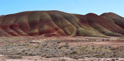
If you take a right on US-26 you head towards the Painted Hills Unit of the John Day Fossil Beds National Monument (H2) from this junction. The main parking area features an oasis of green grass and shade trees perfect for picnics, as well as restrooms and water. Information panels tell the story of the geologic creation of the hills and provides a map of the different hikes and access roads. Whether you hike or just drive by, have your cameras ready and prepare to be awestruck by this unique terrain. All the sights are contained within a small area and we recommend you take every road and stop at each point of interest. The first views of the painted hills are enchanting. Only nature's hand could paint such beauty — layers in a vivid palette of orange, red, black, green, and lavender. The deeply saturated hues are created by different layers of volcanic ash that have oxidized since being exposed to air by erosion. Colors shimmer off the hills and alter at different times of the day and weather conditions. The gentle curves of the dense clay hills are a striking contrast to the rugged surroundings and despite the lifeless look of the landscape, many plants have adapted to the rocky outcrops bringing a wide variety of wildflowers and butterflies. Explore the scenery on three short trails, Painted Hills Overlook and Trail, Leaf Hill Trail and Painted Cove Trail, the latter of which allows you to get very close on a boardwalk that circumnavigates a painted hill. Please do not walk on, or touch the hills as they will be permanently damaged. The Carroll Rim Trail is a 1.5-mile round trip that hugs the mountain-side, climbing 400-feet to a volcanic caprock overlook.
If you take a left on OR-19 you head towards the Sheep Rock Unit of the John Day Fossil Beds National Monument from this junction. Unending sunshine and warm temperatures make for great fruit growing and in Kimberly you will find orchards of apples, pears, plums, nectarines apricots and more. Take advantage of roadside stands or pick your own farms.
Stop at the Foree Area (H4) which features two short quarter-mile hikes offering a panorama of the John Day Valley and volcanic remnants. All hikes along this route offer strategically well-placed benches to soak in the beauty of this area.
Continue south on OR-19, passing the dramatic Cathedral Rock. Drive slowly if you want to take photos, as there is only a small side of the road stop. The surrounding hills are scattered with sagebrush, shadscale saltbush, mountain mahogany and 50 to 200 year old juniper trees.
Back on OR-19, stop at Blue Basin (H3), mesmerizing badlands of pale greenish/blue volcanic ash now turned to stone. Wind, rain and time have sculpted incredible rock formations, pinnacles, creating a veritable cacophony of texture. Two trails leave from the parking area. The Island of Time is less than a mile long and leads to the center of the basin. Interpretive signage, replica fossils and the scattering of small lizards dot the path. The Blue Basin Trail is a three-mile loop around the perimeter of the basin and affords spectacular views. And remember, have plenty of water, a sunhat and sunscreen.
The road continues revealing fascinating views with every curve. Visit the historic Cant Ranch (A4) built in 1917. Tour inside the home of James and Elizabeth Cant, early sheep ranchers in the John Day Valley and discover original furniture, kitchen, photos and artifacts. The upstairs now houses the park headquarters. Next to the parking lot is a small orchard and some antique ranching and farming equipment. Enjoy a picnic under the trees, a welcome respite from the heat and walk the River Trail, which leads to the John Day River and is wheelchair accessible.
A few miles up the road is the well-designed and informative Thomas Condon Paleontology Center (A5). The research facility also serves as a visitor center for the entire monument and staff are on hand to answer questions. Take time to explore the fossils and habitats of eight different “assemblages”, each one an ancient ecosystem beginning 50 million years ago, and watch “A Place of Discovery”, the 18-minute film presentation. It’s hard to imagine this area was once a river flood plain with lush forest, prehistoric horses, elephants and saber tooth tigers. As well, you can observe scientists cleaning and studying fossils from the window that overlooks the laboratory.
The road continues through the Columbia basalt lava flows of Picture Gorge (V1) named for the American Indian pictographs on the walls. There are no official stops here, just a few small places to park alongside the river.
Heading towards Dayville, detour up to the Mascall Formation Overlook (V2) for a spectacular view of Picture Gorge and the Mascall and Rattlesnake formations.
The two forks of this drive rejoin in Dayville, a small town with an historic post office and Pony Express sign, some lodging, a restaurant and a grocery store/cafe.
The Clyde Holliday State Recreation Site (H5) is an extremely well-maintained day-use site and green oasis for tent and RV camping — or snag one of the two Teepees by reserving in advance. Walk the path that travels along the John Day River, and depending on the season, search for crawfish and bullfrogs.
John Day is the big city around here and you will find an array of lodging, dining and shopping options. With plenty of services and central location, John Day is a great base for exploring this region.
Don’t miss the Kam Wah Chung State Heritage Site (A6). The general store and medical clinic was built in the 1870s and became the social hub for Oregon’s Chinese community. The interior is intact — as if the owners Ing “Doc” Hay and Lung On stepped out momentarily. Inside are shelves stocked with supplies, herbal medicines, living quarters, Chinese antiques and more. The Interpretive Center features a video which includes interviews with Doc Hay’s surviving patients. The free museum is open May-October.
Continue east on US-26 toward Prairie City amid beautiful views of Strawberry Mountain.
In Prairie City, visit the Dewitt Museum (M4) housed in the old Sumpter Valley Rail Depot built in 1910. Open from mid-May to mid-October, exhibits take you back to the heyday of rail travel. Tour the first floor waiting room and offices, and head upstairs to the living quarters of the Station Agent featuring antique furniture and artifacts. Also included is a superb collection of rocks and minerals from the DeWitt family, photos and mining tools.
Continue on US-26 to OR-7 to Sumpter. At the Sumpter Valley Railroad (A10), ride an original narrow gauge steam train traveling between McEwan and Sumpter. Also offered are special events such as Gold Rush Bandit Train Robberies which reenact horseback mounted robberies in period costume, foliage excursions, Christmas trains and more.
Remnants of the gold rush remain at Sumpter Valley Dredge State Heritage Area (A7). Once vital to Oregon’s pioneer past, this dredge is one of the largest and most accessible gold dredges in the U.S. Enjoy interpretive displays, trails, and picnicking sites at this day-use site.
Learn more about Sumpter’s gold mining past, the great fire of 1917 and more at the Sumpter Museum and Public Library (M5). Then take a self-guided walk through town or look for treasures at the large flea market held three times each year. The region is also popular for ATV riding and in winter, snowmobiling.
The rest of the drive to Baker City follows a section of the Elkhorn Scenic Byway. Our drive officially ends in Baker City, but there are many places to see once here.
Baker City is a charmer, with over 100 buildings on the National Register of Historic Places in the downtown Historic District. Pick up a brochure at Historic Baker City, Inc. (A8). and explore on a self-guided walk. In Baker City you will find a wide range of lodging options, restaurants, and services. It is also a hub for recreation to nearby regions.
The National Historic Oregon Trail Interpretive Center (A9) portrays and preserves the challenge of the 2,000-mile journey on the Oregon Trail of settler’s westward migration from Missouri. Eighty-years of history is explored through life-size trail dioramas, living history demonstrations, interpretive programs, hands-on activities and videos. The Center overlooks 7-miles of the Oregon Trail where stagecoach ruts can still be seen. Pan for gold, visit a mine, hike the interpretive trails and much more. There is a fee to enter covered by the America the Beautiful Pass.

Other Nearby Places of Interests
National Historic Oregon Trail Interpretive Center (A11): The Oregon Trail Interpretive Center portrays and preserves the challenge of the 2,000-mile journey on the Oregon Trail of settler’s westward migration from Missouri. Eighty-years of history is explored through life-size trail dioramas, living history demonstrations, interpretive programs, hands-on activities and videos. The Center overlooks 7-miles of the Oregon Trail where stagecoach ruts can still be seen. Pan for gold, visit a mine, hike the interpretive trails and much more. There is a fee to enter covered by the America the Beautiful Pass.
Baker County Chamber of Commerce and Visitors Bureau (I1)
Maryhill Museum of Art (M1): More information at www.maryhillmuseum.org.
Share
 | ||||||
| Sun | Mon | Tue | Wed | Thu | Fri | Sat |
|---|---|---|---|---|---|---|
