

Coronado Trail Scenic Byway
Twist through Canyons and along the White Mountains
| Mileage | 119 miles (192 km) |
|---|---|
| DurationThe duration is an estimate of a one-way drive and does not include any stops or side-trips. | 3 hours, 19 minutes |
| SeasonsThe seasons listed are the best seasons for this scenic drive. If Winter is not mentioned, the road may be closed during the winter. | All Seasons |
| Roadways | US Highway 191 |
| ServicesThe cities or towns listed have either Food or Services such as gas, pharmacies, etc. | Springerville, AZ▼, Eagar, AZ▼, Alpine, AZ▼, and Clifton, AZ▼ |
| Rating | 4.0 average from 110 votes |
| My DrivesTrack your favorite scenic drives by selecting those which you want to take and those that you have taken. Using your free account, simply sign in and select My Drives. | |
| Share |

Our free Road Trip Planner will reverse the route and include the places of interests. Click the “Add to Road Trip” above to start planning your next road trip.
Send this link to your phone. Standard text messaging rates apply.
() -Get directions from your start address to the beginning of and including this scenic drive. Choose either an alternate ending or same as start.
Have more destinations? Use our free Road Trip Planner to completely plan your adventure. Click the “Add to Road Trip” above to start planning your next road trip.
Named after the Spanish explorer Francisco Vasquez de Coronado who explored this area in 1540 on a quest to find the Seven Cities of Cíbola, this highway prides itself with more than 460 curves on one of the least traveled federal highways. Enjoy the Apache-Sitgreaves National Forests while experiencing the dramatic change of hot, dry canyons to cool, lush forests at higher elevations.
Our scenic drive begins in the former copper-mining town of Clifton and travels to the town of Springerville, with many opportunities for side-trips, including the White Mountains Scenic Drive. You can reach Clifton from I-10 by taking exit 352 and following US-191 North for 60 miles, where you will enter the canyon created by the San Francisco River.
The mining history is evident as the US-191 twists around the carved open pit mines. One of the most impressive can be seen at the Morenci Copper Mine Overlook (V1). The largest copper mine in the U.S., it produces over 125 thousand tons of copper daily! The overlook provides a unique vantage point to watch the action. If you want a closer look, there is a 2.5 hour bus tour of the mine which requires reservations and an admission fee.
Continuing north on US-191, the road continues its hairpin turns, climbs up and into Chase Canyon, where in a few miles, the road narrows as it passes between rocks and skirts the edge of the canyon. Proceed slowly to best enjoy the view and remember to drive carefully. Stretches of the road do not have guardrails. This amazing scenery and narrow road continues for 15 miles.
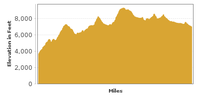
Leaving the canyon behind, you climb into grassland and juniper forests and the route continues above the ridge and along the mountains. In 18-miles, stop at Rose Peak Lookout (V2). From the parking area, take the half-mile hike to Lookout Tower which at 8700 feet of elevation, provides a breathtaking view of the limestone and sandstone cliffs of the Mogollon Rim, the southern edge of the Colorado Plateau in Arizona, scarred by canyons, erosion and faults.
Breathtaking mountain views and ridge lines tantalize as the road continues for 17-miles over the Mogollon Rim. Towards the end of the rim is Blue Vista Point (V3) offering incredible vistas of Arizona’s unique topology, Mount Graham, the Pinaleno Mountains, Blue River, and more from its 9,184 foot elevation. From here, there are a few hikes that warrant further exploration. Consider a stop at the nearby KP Cienega Campground, where Forest Trail 70 (H3) brings you through the red and gray rock wall of the canyon, near a waterfall, and into the Blue Range Primitive Area. Elk, mule deer and wild turkey are regulars in the meadow and forest and be alert for the occasional black bear.
As you continue north on US-191, the forest thickens and the White Mountains become more visible. The next 30-miles from Blue Vista are some of the most scenic along this route as picture-perfect views emerge with each curve around forest and meadows. In fall, the foliage becomes a dazzling array of color. Arriving in the town of Alpine, stop at the Alpine Ranger Station (I1) for information about the area hikes, such as those in Williams Valley (H1). This area is also a popular in winter for cross-country skiing and tobogganing. Alpine also marks the start of the White Mountains Scenic Drive which is an alternate scenic route back to Phoenix. While here, consider a side-trip on US-60 to Luna Lake (W2), a popular fishing stop with several campsites.
The drive skirts the edge of the White Mountains exposing views of aspen forests interspersed with wild meadows. Along the way, you will pass the 10,912 foot volcanic Escudilla Mountain, Arizona’s third tallest peak. Explore the surrounding area by turning onto Forest Road 56 and enjoying a portion of the 6-mile round-trip Escudilla Wilderness Trail (H2) near Terry Flats. The trail heads through an area engulfed in fire in 1951 offering the opportunity to see the progress of nature in its aftermath from the fire tower.
Heading north on US-191, you soon come to the Nelson Reservoir (W1), a perfect place to stop for boating, fishing trout, or with its views of the Escudilla Mountain and the birds that frequent the reservoir, an ideal picnic spot.
Our scenic drive comes to an end as you approach the town of Springerville. From here, consider continuing your adventure on the White Mountain Scenic Drive by turning left onto Central Ave and then proceeding south on AZ-261. Along the way, don’t miss the Mexican Hay Lake (W3), another lake frequented by migratory birds.

Share
 | ||||||
| Sun | Mon | Tue | Wed | Thu | Fri | Sat |
|---|---|---|---|---|---|---|
Send this link to your phone. Standard text messaging rates apply.
() -